Walking Home

reveries of an amateur long-distance hiker

Air

June 15th, 2016

Air (an essay to complete the four elements, see also “water,” “surface,” and “vital heat“)

image

They were burning the fields in Helambu, mountains terraced like a 3-d model of a topo map but nearly as old as human history. First they burn the chaff and straw, then cultivate with short-handled heavy-headed hoes, a design older than the millennium. In the larger fields, a wooden plow is pulled by a yoke of yak, writing simple lines in the soil with a metal tip tapering to a plain point. The plows are carved from a small tree-trunk with a heavy root angled by the winds, water, and rocks where it grew. A handle is mortised at the butt to give the plowboy control over depth and direction. The ashes from the burn are turned into the soil, but only after the fire has filled the sky with a choking smoke. In the villages they heat and cook with wood, often in rooms without chimneys. Instead a hole up in the eaves helps draw some of the smoke from the kitchen. The paths that wind between villages and farms are littered with empty coughdrop blister-packs, an attempt to sooth the irritation of indoor and outdoor smoke. The latter was completely unexpected as I climbed the trail, finally gaining 3690 meters of altitude. Higher than I had ever been but still not above tree line. The forest remained primarily pine and juniper, though becoming more scrub-like as the afternoon progressed. Ahead was a peak the path would go around, but I could see a recent rockslide had sheared off most of its face and the trail rerouted at that point. The foot stones were fresh and there were small cairns signaling the way, but as it turned out, in order to get past the slip, the path went almost to the peak. My altitude sensitive lungs went on full alert. Until this point, the hour estimates printed on my map had been spot on, but the walk from Mangengoth to Thadepati Bhanjyand was listed as one hour and took two and a half. Not sure what the kilometers were, but at this altitude they are of little consequence. The only thing that mattered was the air.

image

It is not surprising that Buddhist meditation practices focus so intently on breath. Spiritus is elusive at altitude. Just moving about in the Himalayas is an exercise in breathing, a palpable factor in all activity. Visiting the gompa at Bhraga required not just a long walk up the Annapurna Circuit but also slow acclimation. The general rule of thumb is not to gain more than 1000 meters altitude per day, and I was by no means pushing myself on arrival at the village. On learning I could see the inside of the monastery which was perched high on a cliff above the village, I had to hustle to get up to it in time. Almost immediately, oxygen debt crushed my stamina. I slowed and methodically made my way to the entrance where I was met by an ancient Nepali doorkeeper who instructed me to remove my shoes and compose my breathing, then led me into an exuberance of Buddhist statuary, imagery, and manuscripts. I wandered in a daze, enthralled at the spectacle and the history it contained (I’m sure lack of oxygen contributed to that daze). On leaving, she tied a thin, blue-green string around my neck (which remains to this day), and I breathed one last time the smell of incense and ancient learning before descending some meters to the village and its relatively richer oxygen world.

image

Bhraga is on the Annapurna circuit in Nepal. As a child I was a voracious reader in a house with a decent but limited library. I remember Maurice Herzog’s account of the ascent (and more important, descent) of Annapurna in the first expedition to summit what was then the highest mountain yet climbed by Western mountaineers. That story remained tucked in my psyche, resurfacing when I read about the circuit. I’ve been trekking long enough to have chucked the “bucket list” mentality over the edge many years ago. My idea was to walk around the Annapurna massif as a sort of pilgrimage, like the Buddhist circumambulation of Mt. Kailash. In my pilgrimage, I would see the villages, people, and countryside but also the places Herzog’s expedition passed, and I would see the mountain that bulked so large in my childhood imagination. Except for ice gear, I carry the equipment necessary to meet most challenges on a trail. The description of the Annapurna Circuit was quick to point out that people of moderate fitness were capable of finishing, so I didn’t worry much about the specifics. My first days out were uneventful, walking without a guide on a well-marked, well-travelled path. As the days passed, I encountered many of the same trekkers, listening to their conversations which almost never mentioned the walk itself. Instead, like a mantra, they repeated the words “Thorung La,” a pass that, at 17,769 ft., was the highest point on the circuit. It soon became clear most of my hiking colleagues were focused almost exclusively on the challenge of that pass. Along with the 1000 meter rule, everyone hydrated relentlessly and many ate lots of garlic, a folk remedy I was most happy to follow. Morning eggs in the guest houses were usually covered in garlic. Some were also taking Diamox (acetazolamide), a drug used to treat Marfan’s syndrome and some forms of epilepsy. It is a diuretic which tends to acidify the blood, causing deep breathing and increasing the blood’s oxygen supply, so it supposedly works as prophylaxis for mountain sickness. For these people, a pilgrimage around and through a remarkable landscape had been reduced to hemoglobin, to blood and oxygen.

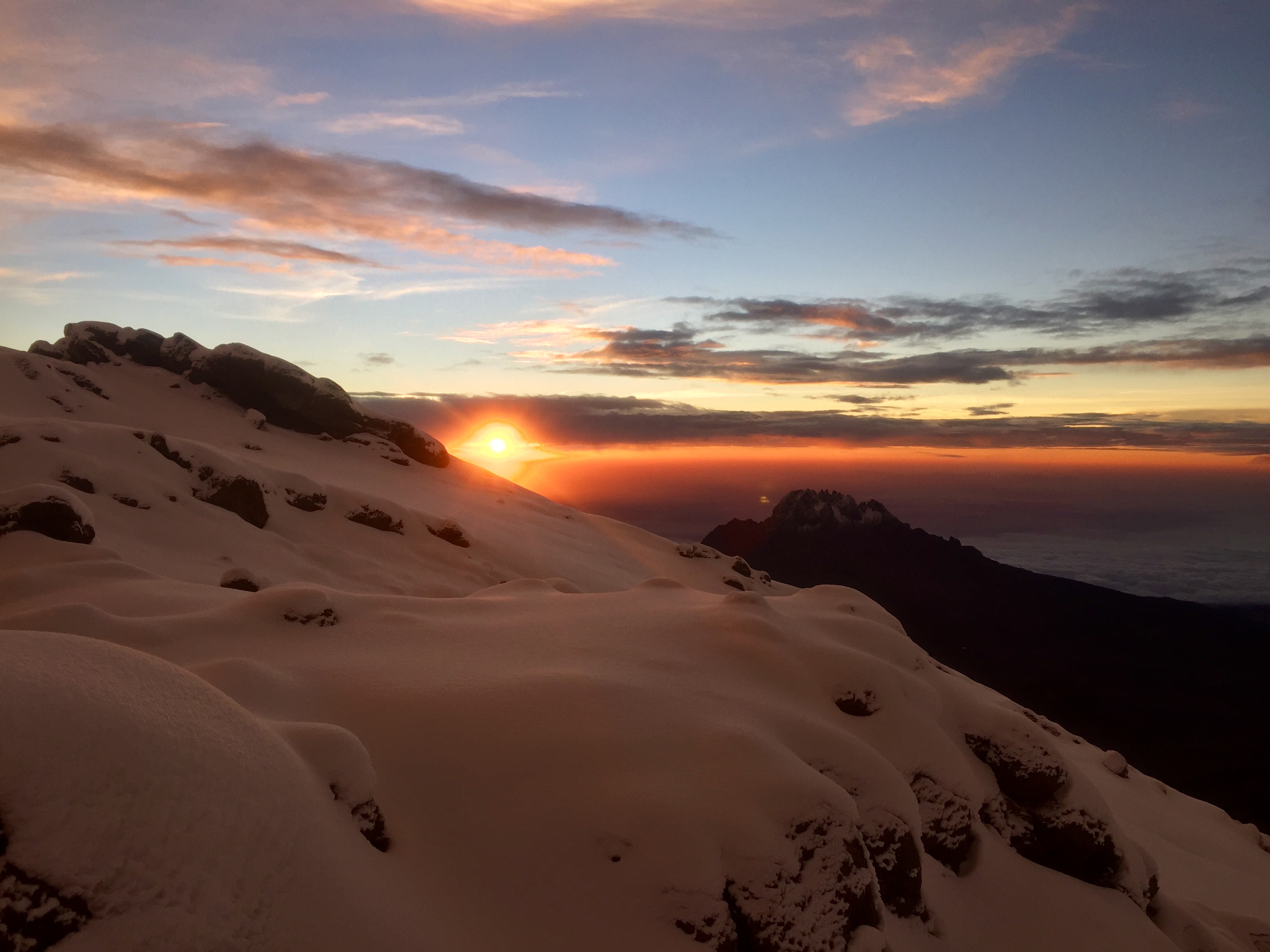
My passage over Thorung La was uneventful. A beautiful but bitter cold day, a long steady climb followed by a hasty descent to Kagbeni, it was satisfying and, by walking at a judicious pace, my blood remained well-oxygenated. A few weeks later, on another continent I came to understand thin air. I began the final ascent of Mt. Kilimanjaro at midnight, but not before asking the guides about the rationale for such a strategy. We had already spent days acclimating, and it seemed unwise to disrupt diurnal patterns just at the moment we were readying for the big push. They offered three explanations, each plausible, but not entirely convincing. The hike up from Kibo huts to Uhuru peak is less than six km with a little more than 1000m altitude gain. The summit is 5895m (19,341′). For comparison, Everest is 29,029′, and the highest peak in North America is Denali coming in at 20,310′. So the first answer had some merit– seeing the sunrise from the crater rim is an incredible experience. People walk up Poon Hill in Nepal starting at 4:00 am to see the sun rise over the Annapurna massif and Daulighiri, but that is a well-marked and fairly short track. Another reason: it was the wet season and the rains tend to start mid-morning, so they wanted to get up and then off the mountain early. The last, which seemed both patronizing and nonsensical, was actually the best. Hikers cannot see what they are climbing in the dark. It might only be six kilometers and only 1000 meters elevation gain, but it is straight up the highest mountain in Africa. At 11:00, we had coffee and biscuits and by the stroke of midnight were walking out of camp, each wearing a headlamp directed at our feet. We soon discovered that rain the day before was snow up high, and within the hour we were in ankle-deep powder, each of us following single file, seeing only the terrain illuminated by our headlamps and concentrating on the footprints directly in front of us. This went on for six hours. Initially, I treated it the way I do all long treks. Walking is an opportunity to think, but walking and thinking at high altitude is a curious and subtle experience. I found while I did the Kili shuffle–placing one foot directly in front of the other, heel to toe with no space between (very much Pink Floyd’s The Wall walk)–I could maintain a train of thought, but soon the lack of oxygen took effect, and I could only focus on the feet stepping in front of me, step after step, hour after hour. Climbing in snow is physically taxing, and as the air thinned, every misstep or slip interrupted carefully patterned breathing which in turn made me stop to pant, trying to get oxygen balance back. The new snow slowed our pace, so we arrived at Gilman’s point on the crater rim much later than expected. Kilimanjaro is a dormant volcano– a singular peak rising out of the Rift Valley that characterizes the geology of East Africa. We rested briefly, and for the first time could see beyond the halos of our headlamps. The sun washed across the landscape, making shadows of unbelievable intensity and finally breaking the monochrome of our night walk. By now I was really feeling the altitude. I had crossed Thorung La with little distress, but given the exertion of climbing in snow, I was gasping for air and feeling many of the symptoms of altitude sickness. Nevertheless I continued the last bit of the climb around the crater rim to Uhuru point. There were congratulations all around, but what stunned us all was the sheer magnificence of a clear, rainless morning looking out over the glaciers surrounding a breathtaking crater (and I mean breathtaking in its most literal sense). We soon turned back– lingering at the peak invites many problems including body-temperature drops and perhaps more time sliding down the incline in the rain. We made our long return to Kibo huts, and each step brought more oxygen. After a glorious hour resting, we geared back up and made the descent to Horombo, had supper and slept the sleep of the dead. Emily Dickinson once wrote that “the brain is wider than the sky.” On Kilimanjaro, I learned that a tired, physically stressed, and oxygen-starved brain is no wider than the faint outline of a headlamp illuminating footsteps in the snow.

image

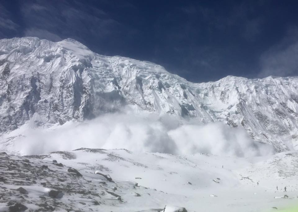
Air signals its presence in other ways, perhaps most directly by moving. In Nepal climbing to Tilicho Lake, I watched the snow on a mountainside break off, sliding into a ravine a couple of kilometers from where I walked. There was no danger the avalanche could reach the trail, but in a few moments the clear sunny day was filled with airborne ice crystals moving east fast and wet. About 20 minutes later, the same ricocheting wave recrossed the path, this time moving west, once again covering me completely in ice. The Tongiriro Crossing on New Zealand’s North Island involves altitude change though nothing like Kilimanjaro. The edge of the Red Crater is a little over 1800 meters and when I was to cross during my hike of the Te Araroa Trail there was still snow, a lot of it. Tongariro is one of those hikes that swiftly changing weather can make dangerous. My morning started out cold (down at low elevation) and wet, though there were glimpses of sun, and the cloud cover did not look significantly different from a typical New Zealand morning in late Spring. My plan was to first hike to the Ketatahi Hut which was about 18 km, so I hoped to get there mid-morning and would then have a sense of how the weather would play out. Early on the hike went well, a long road walk followed by well-designed and maintained paths. When I emerged from the bush and started hiking the alpine tundra the temperature started to drop, and the wind picked up. Still, I was well dressed in wind/rain gear, ready for what I thought would come, but the rain intensified and the wind was soon gale force. At times it actually pushed me off the trail. The last kilometer or two were otherworldly– horizontal rain, freight-train wind, and no clear end in sight. Then the hut appeared (not a moment too soon). The first thing I saw when I got to the door was a sign redesignating the hut as a temporary shelter. It was not an overnight site any longer because of a recent eruption which had dropped rocks through the roof and disrupted the foundation. I went inside, stripped off wet clothes, and with shivering hands made an early lunch. As I did not get appreciably warmer–the wind by now was bashing the sides of the cabin– I spread out my sleeping bag on the table and crawled in, which soon got my body temperature to a better range. Before long some Department of Conservation people showed up to work on the hut, surprised to find anyone there in such weather and relieved that I had decided to return down the way I had come. I packed up, headed back into the maelstrom, and could feel the temperature creep up as the altitude decreased. While hiking back down the mountain, I thought about Thoreau in The Maine Woods where he climbed Katahdin, though he did not achieve the summit. His description of the mountain is some of his best writing, and I was thinking about how to him Katahdin was a cloud machine, making its own weather. He did not end up posing at the top for pictures the way Appalachian Trail thru-hikers do today, but he experienced the mountain in all its weather fury. From that perspective, his was a successful climb, as was mine that day on Tongariro.

Another of Thoreau’s mountains is New Hampshire’s Mount Washington, a place where the air asserts itself insistently. It is a mountain with a constant flow of tourists. I remember one day climbing it through the Tuckerman Ravine with one of my sons. Like Katahdin, Washington is also a cloud factory, so on nearing the summit the mist came in. Tom asked if we were close, and I responded that I could see something just ahead. As it turned out, that something was the bumper of a car. We summited through a parking lot, then stood next to tourists in street clothes waiting our turn to snap a picture by the sign at the peak. Flat and exposed, Washington is situated at a point where major storm systems from the south and the west converge. It can have temperatures as low as -35 and, at 231 mph, the highest wind speed ever directly recorded by humans. It is no wonder that in the past 150 years, almost the same number of people have died on its slopes. Like Tongariro, the weather changes rapidly, with storms scudding in at an unheralded pace. Standing at the peak, ignoring the cog-railway and full parking lot, watching the clouds mark the wind direction and speed, is to experience air as air.

image

Today when people speak of a medium they might be thinking of a trafficker in the spiritual realms but more likely are referring to a communication medium. I currently teach in the newly re-named School of Literature, Media, and Communication, where media finds itself squarely in the middle, sandwiched between an elderly media form and the study of how to get the message through as clearly as possible. At least since McLuhan (actually since Plato), people concerned with effective communication focus not just on the message but also on its medium since, obviously, its specific affordances configure the messages that pass. Idealists desire transparency, the mythic state where the medium recedes to such an extent that the message stands clear for all to see and understand. In Remediation, my old friend and colleague Richard Grusin makes the distinction between immediacy and hypermediacy, where the first characterizes the push for transparency while the second calls attention to both the limitations and the affordances of the medium itself. Similar to Heidegger’s tools “ready-to-hand” and “present-to-hand,” immediacy and hypermediacy are engaged in a constant dance. One leads for a moment, then the other, as the message is passed and its medium registered. In the last half-century, we have come to think of information moving through a medium as fundamental to the maintenance of society and vital for continuing life through our very genetic structure.

In a climate-controlled environment (at least in the West), air rarely shows itself as hypermediacy. Instead it seems textbook immediacy. Indeed, except for startling instances of dense air pollution (or to a trekker on the Helambu circuit during spring field preparation), the primary characteristic of air is its transparency. Something invisible, beneath notice, surely does not carry a message of consequence, but of course it does. We respond somatically to changes in air pressure. We feel deep in our souls the freshness of a clear cool morning. We feel the oppressive weight of water on a humid day, and a stiffening breeze signals a change in the weather. The down on our cheek trembles in the slightest current of air or shift in temperature, but what makes air so clearly a medium is its very transparency. To experience the big outside on an exceptionally clear day is to be enthralled by its clarity, by exactly that which you cannot see. As William Carlos Williams says in the first poem of Spring and All:

under the surge of the blue
mottled clouds driven from the
northeast—a cold wind.

* * *

Now the grass, tomorrow
the stiff curl of wildcarrot leaf

One by one objects are defined —
It quickens: clarity, outline of leaf

The transparency of the air there does not withdraw in the face of the immediacy of the object–it produces it, enables it, and mediates it. Air is our first medium.

image

T. Hugh Crawford

Feb 22

February 24th, 2016

Feb 22

image

An early morning gong booming, the singing of prayers by my friend, and the crowing of roosters stirred me out of bed. Today’s goal was Kakani, which should have made for a short walk, though I was having trouble reconciling my GPS device with the published Helambu map. On the map, Kakani is a town with full amenities (school, monastery, and a guest house), but it does not even appear on my GPS, nor does the trail for this section. Not worried about getting the Helambu merit badge, I plotted a route to get me generally in the place I needed to be. The Helambu track is basically a hike up and down a river valley (the Melamchi River). Starting on the western side, it follows high ridges until Thadepati, then drops down to Melamchigaol which is at the headwaters, so today’s trek would be down the eastern side of the river valley. I lounged in my cot for a while before starting to pack and then was called to breakfast which definitely included “free range” eggs as they were from the yesterday’s rice-eating chicken. Couple that with a pancake covered with honey and two cups of black tea, and I was ready for the day. Not anticipating a long day’s walk, I roamed the village a bit, peering into the wreck of the monastery. One room not completely destroyed had a huge prayer wheel, still there but tilted and unspinnable.

image

There was a Buddhist monk in robes and some high tech running shoes- such is the modernity of Melanchigaon. After saying warm goodbyes to my hosts, I turned my head south. The descent out of the highlands was not easy. The path was clear, but the way was steep. Just below Tarkeghyang there were two routes south according to my map. I chose the one to the right hoping it would lead to Kakani. It was a well-formed road that was no longer used by vehicles because of rockslides. On the way out I stopped by a stream for water. Many of the people living here will make a small pool in a falling stream, four or five inches deep, and then punch holes in the base of a half-liter plastic soda bottle and attach a hose coupling to the top. Place it in the pool and run the hose to the house and, voila, instant plumbing. Taking care not to disturb anyone’s water supply, I filled my Nalgene and then steri-penned it, missing those days on the South Island of New Zealand where you could scoop a liter of icy water from a stream and drink it down without concern. On the road, I soon passed a very old, slow-moving man who was partially deaf. I startled him as I passed giving the traditional “namaste.” He then smiled and asked “where?” I replied “Timbu” as it was the primary place-name on both maps. He nodded, saying he was going there too. We walked together briefly, but clearly our paces did not align, so bidding him goodbye I went ahead. The roads have many switchbacks sometimes cut short by footpaths. Very soon after parting, I heard a sharp whistle, and the man stood there gesturing toward the footpath just in front of me instead of the road. I smiled, bowed, and thanked him as best I could from the distance. He saved me a kilometer or more, and it was a path well-worth walking, going through a series of recently cultivated terraced fields, including some full grown with winter wheat. Still, most of the day was a long road walk and the dust was inches deep. There were wide flat spots, but when slides occurred, it became steep and narrow, requiring serious concentration. I lost altitude all day, and one point found myself going down a steep switchback just behind some teenagers. There was a youth camp nearby and they were on their way to a ceremony dressed in their absolute best Nepali clothes but still goofing the way a group of teenagers does. As the day wore on, I considered going straight to Timbu which was clearly a decent sized village, but my map did not show lodging there. It did indicate a small trail heading up to Kakani from the road, so at a cluster of houses I asked about the town. According to my GPS I was only about 2 km from Timbu, but it was midday, plenty of time to find Kakani. Some men pointed toward a steep path which I followed for more than a half hour. Walking was difficult because they were preparing the fields and the dirt was soft. Halfway up were a number of women with short heavy hoes working their way through the narrow terraces. They waved, signaling I should continue climbing. Near the top, the path gave out, and I made my way to the edge of a set of freshly planted terraces. With some difficulty I climbed up (they are an unwieldy height) and found myself at the back side of a village. Walking around, the entrance to Kakani (or maybe Gangyul? It is unclear as the maps conflict) was a stupa and a school on a hill. A sign for a hotel and cold drinks greeted me, but walking up the path revealed only rubble. At a nearby house, a young mother said there were no guest houses in town, but she sold me a cold Mountain Dew. I’m fairly certain its been at least 45 years since having one of those. I shared a little with her young son who drank with a frowning seriousness, then set off for Timbu which now was over six km by the road. My choice was to go back the way I came, or hoof it hard down the road. Putting on my seven-league boots, I took off, descending rapidly. Down lower the plants became tropical, including what looked like banana trees. Just outside a house near town, an elderly woman walked out as I passed giving me a very loud and happy “namaste,” and then said “Timbu!” pointing down the slope. It seems the only words I share with the Nepalese are greetings and place names. Another kilometer brought Timbu with only one hotel that had no rooms available. They offered to let me sleep outside on a small patch of grass next to a pen with some large black Nepalese cows (they made a strange grunting sound all night).

image

After pitching my tent, I opted not to hang out with the cattle and instead returned to the hotel for drinks and dinner, starting with a large cold beer which just then was indescribably delicious. I sat in the setting sun watching a crew of men hand-hewing beams for floor joists. They only flattened two sides and didn’t worry if the log was crooked as long as the two flattened sides were in the same plane. It was fascinating work, reminding me of hewing beams with broad axes on the Thoreau House Project some years ago. The hotel had a large kitchen garden and the owners had many children. The older ones were harvesting large roots they called taro while the younger ones whooped, hollered, and fist bumped me while I tried to write. An uncle showed up with a freshly caught fish–looked like a Nepalese catfish–which he cleaned with a large cleaver sharpened on the concrete curb while, on the hill above, an old woman sat cross-legged winnowing grain with a large flat basket. There was too much to see. They offered fish for dinner, but the younger children were so excited about it, I had dal bhat instead (again). The sun set and I made my way to the barnyard, now joined by some stray dogs, and crawled into my tent content.

T. Hugh Crawford

Feb 21

February 24th, 2016

Feb 21

image

A light rain last night cleared the wood smoke and haze from the air, and the sun shone on a bright morning at Hotel Namaste. I breakfasted outside on pancakes with yak butter which tastes much like cow’s butter only more oily and has a tang– that might be because they have no refrigeration and it is a bit rancid. After making my farewells to the family, it was off to the longest ascent of this trek–over about ten kilometers going from 2470 to 3670 meters. For a little context, that is 12,040 feet. Mt. Katahdin is 5269 while Mt. Rainer is 14,409. This first bit was fairly level and good walking, and I soon arrived at a small village, more like a checkpoint, complete with automatic rifle toting military personnel charging 3600 NPR to enter the next part of the trek. Money is something of a concern as there is no way to use a card and most places places will not even take a 1000 NPR note. After the checkpoint, the path was very steep for about two hours. My cold (which has gotten worse) and the altitude forced many short breaks. Even though the sun is shining and I am sweating in just a t-shirt, there are patches of snow in the shadows and occasionally the trail ices over. The forests have transitioned from oak and beech to pine and juniper, but still have the ubiquitous rhododendron. By 11:00 I arrived at the outskirts of Mangengoth, stopping for lunch at the GreenView Lodge, a place run by relatives of the Namaste Hotel family. Like most larger buildings up in the mountains, the lodge has strings of prayer flags across the surrounding open space, and their fluttering always triggers old memories. When I was growing up in the valley of Virginia, the gas stations (what we called “filling stations”)–Esso, Sinclair, Cities Service — had traditional street signs but also decorated their lots with guy wires strung with multi-colored flags and spinning propellers. It was always easy to find a station because of the color and motion. Catching that moving color here out of the corner of my eye, I get a twinge of recognition. But here, up in these mountains, resting on a stone wall beside yet another ruin, the flags make it sound as if someone is still there rustling about. The descent from Mangengoth took me across fields past empty but still functional buildings, then the path got serious as it climbed up from 3420 to 3690 meters. That is definitely higher than I have ever been, but here it is still not above tree line. The forest remained primarily pine and juniper, though becoming more scrub-like as the afternoon progressed. Ahead was a peak the path would go around, but I could see that a recent rockslide had sheared off most of its face. As I feared, the trail rerouted at that point. The foot stones were fresh and there were small cairns signaling the way, but as it turned out, in order to get past the slip, the path went almost to the top, and my altitude sensitive muscles went on full alert. Until this point, the hour estimates printed on my map had been spot on, but the walk from Mangengoth to Thadepati Bhanjyand was listed as one hour and had taken 2 1/2. Not sure what the kilometer’s were, but at this altitude that is of little consequence. On that path I did scare up two magnificent birds which I think were pheasants– large, with bright blue head feathers that ruffled at the crown. Finally made it to Thadepati and debated finding a room there or descending to Melamchigaon. The latter was only another four km and all downhill, but it would be very steep. Not wanting to start something I couldn’t complete, I rested and evaluated my physical status. The Te Araroa had many long afternoon descents so I understood my limitations but needed to factor in altitude. At the top was a lone man who ran the lodge. We sat and talked as best we could, but mostly enjoyed the warm afternoon sun on those high rocks. I pushed on. It was a steep descent that took several hours moving rapidly through microclimates finally settling into a beech forest, a tree I’ve always loved though near the bottom the piles of leaves obscured the path which made me wonder if the beech here, like those in Georgia, hold their dead leaves until spring when the new leaves push them off. That would explain why here in late winter there are so many intact leaves obscuring the path. After crossing a rickety swinging bridge and climbing a hill, I found Melanchigaon, excited about visiting the Buddhist monastery there. Walking down the alleys–there is no main street–all was rubble. This town too was severely hit by the quake with barely a stone building left standing. The monastery was perhaps the saddest, with its beautiful multi-layered roof tilted and fallen.

image

The Himalayan Lama Lodge had also fallen in, replaced by a wooden structure with a corrugated roof. I was met in a tiny entry yard by a man with a welcoming glint in his eyes who called himself a lama. His wife joined us, her face framed by a copper-colored head scarf, and we all three watched as one of their chickens pecked up the rice that had just been dumped on the bare dirt. I arranged for a room and dinner, and she kindly showed me my room, a space defined by 3/4″ boards set out under the large metal roof. It had several narrow cots and a breeze coming through the cracks and knots. Glad I carrying a 0-degree sleeping bag. Next door were the toilets, showing a certain humor in the face of such devastation. One labeled “Eastern toilet” was a traditional porcelain footprint over a hole with a bucket of water and dipper nearby. The other door, labeled “Western toilet,” opened onto a pile of rubble. For dinner, the woman offered a menu but her husband definitively said “Dal Bhat,” so it was settled.

image

Still suffering from a cold, I took a short nap, then joined them for dinner. Like the Namaste Hotel, the room was low and dark. Toward the back were piles of bedding. This building was corrugated steel like so many others– hard to keep warm and equally hard to keep cool. Across the front wall were wooden shelves holding all of the food storage, condiments, and utensils. Along with huge teapots, the primary cooking pots were pressure cookers polished to a high sheen. All the metal pots, cups, and plates were scoured to a high shine, which I have a hard time understanding. Back in my Boy Scout days, cooking with aluminum cookware over an open wood fire would blacken a pot beyond cleaning. Here the brightware is bright and they seem not to even use soap. In the middle of the room by that wall was a wood stove. Set on a concrete slab, it was a u shaped low masonry rim about six inches high topped by a sheet iron plate with a large hole in the middle and a hole at the back for the steel pipe chimney. Wood was fed through the open front under the iron plate. I was invited to sit on the rug-covered floor next to the stove–the only warm place available–though I was careful to leave the space right beside the stove for my new friend, the somebody lama. He sat close, put his hand on my knee and smiled deeply, such a warm and welcoming man. We shared few words but were able to determine relative ages –I’m 59, he’s 63–and then we both settled into the quiet while his wife prepared the meal. She did most everything though he would occasionally hop up to stir things or bring in more wood. She talked the entire time she was cooking, though I don’t think it was directed toward anyone in particular. Rather it was part of a marvelous choreography of gestures. There was no kitchen–no granite countertops (though I bet granite mined here finds its way into upscale American kitchens), no Sub-Zero refrigerators, gas range, or microwave, not even cabinets–but her skill and dexterity was a show, and of course the meal was excellent. We sat there together, huddled around the dying stove, each glowing according to our own satisfactions. Reluctantly I took my leave and groped my way in the dark back to my cot for a good night’s sleep.


T. Hugh Crawford

Feb 20

February 23rd, 2016

Feb 20

image

Slept straight through the night and woke at 6:00, courtesy of my fellow hotel guests. The people of Nepal tend to be early risers, one of the things I most like about the country this far. Went to sleep at 8:00 so that was 10 hours plus the three or four of my nap– I hope it is the altitude, otherwise something is really wrong with me. Definitely plan to take it slow today. Sima, the daughter of the hotel manager was also up and at it early. Yesterday in the car the driver was playing traditional Nepali music though by modern musicians. It was fascinating but will require some diligence to appreciate. In the hotel this morning, some young Nepalis started their day with the Grateful Dead — quite a contrast but somehow fitting. Electricity here is usually off, and the hotel’s backup light system is on the shelf– a trickle charger and a car battery. I’m stiff this morning, feeling my age. These last weeks I’ve questioned these treks, wondering if I’m being selfish or even foolish, but then I look out at these mountains and realize that in a few years I won’t be able to explore them on foot which is the only way to do it. The construction workers, young and old, squat over piles of rubble, picking out bricks and cleaning them with masonry hammers. When they get a good pile, they load them in baskets with shoulder straps and a tump line (a strap that goes across the forehead), squat down and slowly rise, carrying the load to the mason’s building the wall. Leaving Chispani was an easy walk to Pati Bhanjyang along a dirt road. On the road I kept seeing lines of small caterpillars. They looked like little wooly bears nose to tail in a line ten or fifteen long with a leader burrowing through the dust. A Land Rover passed me and offered a ride, but I’m not ready to yellow blaze this one just yet. At Pati I started to go the wrong way, but some men on the hill yelled and pointed the right direction. Turns out the trail was a set of steps going up to a hotel, and then curving around it to go straight up a steep hill. Since much of the rest of the day would be spent climbing, I stopped and had a Coca Cola, the first in at least a decade. It was pretty much the only thing in the window, and I thought a little caffeine would help my head. It was a Saturday so there was a crowd in front of the restaurant part of the hotel (more a counter than a restaurant) and the woman behind the counter overcharged me for the drink. I hiked on out and at some point made a wrong turn and ended up walking a path parallel to the Helambu for a few kilometers taking me through the village of Chipling before rejoining the true path up on a high pass. Altitude for much of the day was around 2400 meters, and I seem to be adjusting fine to it now (which is good as tomorrow will be spent around 3600). My navigational difficulties result from my iPhone GPS program spelling the names of the towns differently than my paper map. The map does not have enough fine grained information to help me decide which way to turn at an intersection which makes the phone valuable, so coordinating information between them requires patience. That’s the price I pay for not using a guide. Clearly it is an unusual choice (everyone is surprised that I am alone) but I so prize my walking solitude.

image

The entire day smelled of smoke as the farmers are burning off the terraced fields in preparation for spring planting. Some people had finished burning and now were turning their fields with short-handled, heavy hoes. Part of the day was through a bamboo forest, and just outside Chipling a man was splitting bamboo with an axe that had a bit with a lengthened, curved heel tapering to a point. I watched him split for a while, and he then showed me a curved knife similar to a machete he uses to cut the bamboo. Much of the day was hiking through an agricultural countryside. At one point I inadvertently drove some stray cattle back along the road to a village. Unlike in the States or New Zealand (with its almost mythic no. 8 wire), here there are no fences. Most people’s livestock are a cow or two, maybe half dozen goats, and some chickens. They keep them tied, sometimes turning them out to forage. Chickens peck around the yards, but are also kept individually under large baskets. They just plop the basket over them–instant chicken coop. My plan for the day was a short hike to Golphu Bhangyang which the map lists as having several guest houses. Most of the town was rubble, so I pushed on. I’m curious what the villages looked like before the quake. It is easy to see the effect it had on large buildings that are now on the ground, but I wonder how the individual houses were constructed. Today they are mostly wood frames sided with corrugated steel and seem temporary. I slept in corrugated steel huts hiking the Te Araroa. They keep out the wind somewhat, but are very cold. They do not retain heat in winter and are like ovens in the summer–a point confirmed by a woman I spoke with in a village here. Hiking out of Golphu, one of the last houses I passed was a low structure. As I walked by, I saw a counter displaying sodas and candy bars. Through the door were two men sitting at a table eating heaping plates of some dish I did not recognize. I think it was rice, vegetables with eggs mixed in. They motioned me in, and I took my place at the next table sitting across from a very old woman with a deeply lined face and legs as thin as sticks. I asked for tea, and the proprietor went outside with a pot, presumably to get hot water from a open fire. Accompanied by the loud lip-smacking and belching of my dining partners, I had a delightful conversation with the old woman though the only words we shared were Chisipani (my starting point) and Kutumsang (my ending point). The rest of the conversation was her talking and me signaling how I looked forward to sleeping in Kutumsang. The tea room had a dirt floor and the inside of the corrugated steel siding was lined with split bamboo, perhaps the handiwork of my axe-wielding friend. Every one there told me Kutumsang was a two hour walk which turned out to be accurate. Measuring distance here by kilometer makes no sense. You can toil an hour just to walk up a half kilometer’s worth of steps. Near the top of my long climb out of Golphu, I passed what must have been a small village complete with a guest house. It was arresting as all the buildings were now on the ground, and the place was deserted. Eight thousand people died in the quake, but I wonder now how many have been displaced and moved to the city. Most of the fields seem to be well-tended, so there are plenty of people here still working, but I did pass ones that were abandoned near the deserted village and wondered where the people went. There was an eerie silence there, save the rustling of faded prayer flags.

image

On the map, Kutumsang is a village of some importance, but it too was devastated, so much of the “downtown” is rubble. This morning on leaving Chisipani, I discovered there were several hotels a little further into town which looked more inviting than the one where I stayed, so I made a mental note to walk most of a town before settling on lodging. In Kutumsang, I got to the Namaste Hotel and stopped. There a young woman with a baby welcomed me, we negotiated a price that I hope was generous, and once again I took a nap. That evening I was invited to sit with the family in the only warm room while the mother of the young child made Dal Bhat, clearly the dinner of choice on the Helambu trek. A wood stove is set into the floor in the room, and the baby’s father sat on a pile of rugs on the floor next to the stove keeping the one year old entertained while his mother and grandmother worked on the fire and cooked the meal. The child has one Western toy– a plastic friction powered car that looks like something you would get from a gas station promotion. He played with it, or rather his father played with it as he turned to all the bright colored plastic buckets on the lower shelf– small chaos ensued. Later the grandmother brought in more wood for the fire. Some small pieces were cut from old boards, and she set them up like blocks for the baby to knock down, a gesture accompanied by loud giggles. The mother kept singing “baa baa black sheep, have you any ool?” (she really didn’t need that “w”). It was fascinating watching the meal being prepared. Lots of big teapots and pressure cookers were placed over the holes on the flat top of the wood stove where flames from the fire shot up. She understood the heat and let things cook as if they were on a temperature controlled stovetop. She ground her spices and garlic with a mortar and pestle, scooping the material out deftly with a large silver spoon, one of many beautifully decorated ones which were hanging on the wall. I ate with the family, all the time laughing at the antics of the child. Such warm people, living so well.

image


T. Hugh Crawford

Feb 19

February 23rd, 2016

Feb 19

image

The combination of a upper respiratory infection, being out of shape, and altitude changes made for a short hiking day. I took a car from the center of Kathmandu to Sunjarijal, a small town out on the edge of the big city’s sprawl. It was a national holiday, and the traffic was bumper to bumper the whole way out, my driver zigging in and out of his lane. Actually “bumper to bumper” sounds much more orderly than it was. There were lines at the gas pumps, hundreds of motorcycles filling the street looking like the start of a long distance race. There was garbage being burned in the gutters, and even a dead cow on the side of the road along with a number of live ones lying in the gutters on top the garbage–quite the scene. The Helambu Trek is in the northeastern part of the Kathmandu Valley, an area hit very hard by last year’s earthquake. I was grateful to be outside the city finally, though it does go on for miles. The trail today was up through the Shivapuri Nagarjun National Park starting out around 1200 meters and topping out at 2430 before descending down into Chisipani (that is 7972 feet which is a good bit higher than all the East Coast mountains). The path was not so much a nature trail as it was the path that people living in these mountains use to get around. It passes through a number of settlements which are primarily subsistence farming, growing winter wheat and then corn on terraced hillsides. Many goats and some cows are tethered by the buildings, most now eating corn stalks or forage cut from beech trees. After the first long set of steps, I was stopped at a military installation to buy the permit to hike an Eco center. It was a little intimidating at first since the soldiers carried automatic weapons and frowned the way you would expect them to. I talked to several and all were surprised I was hiking without a guide. They asked if I had children (a very common question) and soon one young man wanted to come along. We all laughed a bit stumbling through language. After the ticket agent finished his mid-morning meal, I got my pass which was immediately checked by the military man I had just finished talking to. The nature preserve is supposed to have leopards, monkeys, Ghoral, Himalayan Black Bear, and wild boar. Listening intently and watching carefully, the only thing I heard was a large animal moving through the jungle at a pace more closely resembling a domestic farm animal. On my way out of the park I did see a cow in the woods chewing beech leaves. The forest included oak and rhododendron, so parts resembled the “green tunnel” of the Appalachian Trail. In Mulkharka, a small village, I sat for a while at a “tea room” front porch. It was a stone building with a lot of packaged drinks in the window and some plastic chairs out under the porch. Across the way a woman was boiling water in a huge kettle over an open fire to wash clothes. The proprietor of the tea room, who only spoke Nepalese, was cooking over an open fire in the front yard. Her cousin, who lives in the city, was visiting for the holiday, and we talked about the many dialects spoken across the country. A handsome young man whose phone would go off occasionally but still he seemed right at home in this distant place. Like the others, he asked why I walked alone. I told him I liked the solitude, and he said “solitude makes for thinking.” By noon, after climbing what my phone said were 250 floors, I was unusually exhausted and found myself taking breaks every couple kilometers. The last two into Chisipani were downhill, but I was still feeling it. The town has several large masonry hotels but the earthquake hit hard, completely destroying several of them. Two were still intact, but had moved off their foundations and were sitting crooked in a field.

image

I went to the Hotel Annapurna Mountain View–Annapurna was nowhere to be seen given the smoke and haze. The proprietor, a nice 22 year old man with a beautiful 2 year old daughter named Sima, showed me to my room which was bare concrete with a few very hard beds– exactly what I expected. I got out my sleeping bag, put my sleeping mat down and immediately fell asleep from mid-afternoon until six. They called me for dinner — Dal Bhat (Nepalese lentil curry)– and brought many extra helpings. After a quiet meal I went straight back to bed. This altitude is kicking my ass.


T. Hugh Crawford