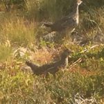
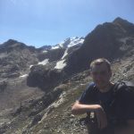
Animals
Animals Pacific Crest Trail, August 2015 One of the first things to strike you on the northernmost part of the PCT is a pervasive silence. The forests breathes, but the birds and squirrels generally don’t chatter (except in Canada; Canadian squirrels make a racket!). It’s like being in a pre-Internet library. Not to say there […]
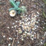
Foliage
Foliage (Pacific Crest Trail, August, 2015) Starting out, the plants are two–Douglas Fir and blueberries. The ancient trees loom. They have dominion. But the blueberries proliferate, and they are flavor. Their bushes vary in size and color, as do the berries. The ones with red leaves growing close to the ground seem always to give […]
August 11
August 11 Darrington WA 0 trail miles Slept in, walked to Glacier Peak Cafe (instead of Glacier Peak), biscuits and gravy, then to the Mountain Loop Book Store & Coffee for quiet, non-hiking backpackless morning. Walked around town a bit. The Red Tavern was packed at 1:30 on a Tuesday, not a good sign. The […]
August 16
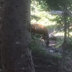
August 16 Hopkins Lake- Manning Park 15 miles 7:45- 1:00 Woke to sunshine, lay in the tent for a while watching a deer about 10 feet from us munching the moss where one of us had pissed– they love the salt. Then we were up and could smell the barn– possible lunch in a restaurant, […]
August 15
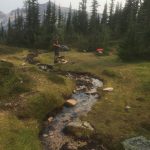
August 15 campsite to Hopkins Lake 18.4 miles 8:15 – 3:30 Slept in a bit hoping the sun would come out and dry things– no luck, we used up out karma on the first part of the trail. Very misty, so we packed up wet gear and headed out, making good time on a gentle […]
August 14
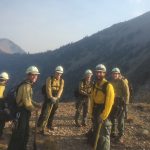
August 14 campsite to campsite 15.7 miles 5:45 – 1:15 It was a James Taylor Day — Fire and Rain Very early morning started to rain. I was cowboying, and Toasted Toad (a thru-hiker) was packed up and headed out. The Rangers were closing trails because of fire threat as we move north, so we […]
August 13
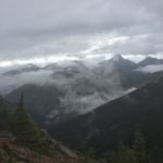
August 13 campsite to campsite near Glacier Pass. 11.2 miles 9:45-1:30 Slept in and hiked short day to position ourselves to cross a long stretch with little water– long days tomorrow and the next. Still in smoke as we left, but it slowly disappated over the miles. Uneventful day, passed some Canada bound folks–short […]
August 12
August 12 Rainy Pass to campsite 9.8 miles (after 72 mile hitchhike). 1:15-4:30 Slow start out of motel, picked up biscuits at IGA and went to intersection to hitch. We needed to go up 530 to Rockport, then take 20 to Rainey Gap. First ride was nice guy but only about 11 miles and left […]
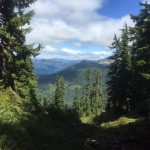
Surface
Surface The Pacific Crest Trail in the Northern Cascades of Washington has a surface that, when not scree, is soft, springy soil composed of fresh and decaying needles, cones, and wood from the giant trees that dominate this world. Dig down a few inches and you will find grey sand– fine particles of granite, […]
August 10
August 10 campsite to Darrington 17 trail miles 6:45-12:15 (then a lot of hitchhiking) “Thumbs out” Up early. Last night a wonderful older couple from Arizona whom we had bumped into earlier came in to our small site. They had hiked the AT to celebrate his retirement, and now were finishing the PCT. Almost […]