Walking Christo’s Floating Piers
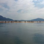
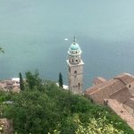
Christo’s “Floating Piers”: Learning to Walk Finding myself in Milan after nearly a year of long-distance trekking, I couldn’t pass up the chance to walk on water. Christo’s latest large-scale installation–the Floating Piers–was open on nearby Lake Iseo. Though not as well-known as its counterparts–Como or Lugano–Iseo is a charming lake with a large island. […]
June 14-19
June 14-19 Milano The interval at the end of a long-distance trek can be a curious time in several senses. It is curious or peculiar because it is the time of not-walking following a long time of walking. Daily rhythms and concerns require new calibrating, infinite adjustment. It is also a time that requires curiosity, […]
Air
Air (an essay to complete the four elements, see also “water,” “surface,” and “vital heat“) They were burning the fields in Helambu, mountains terraced like a 3-d model of a topo map but nearly as old as human history. First they burn the chaff and straw, then cultivate with short-handled heavy-headed hoes, a design older […]
June 13
Brusino to Chiasso 22 km The last day on a long-distance trek is obviously one of mixed emotions. The trail has been home for a month or more, you are in a particular rhythm that is comfortable, and the non-walking life never holds much appeal. Nevertheless, there usually is some need for rest and refueling (I’m […]
June 12
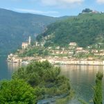
June 12 Lugano to Morcote 12km Sometimes on American long trails, people arrange transportation support so they can hike a stretch without a full pack. It’s called slack-packing, something I try to avoid as carrying the pack is very much part of walking. Today however, I had a short but very steep leg of the […]
June 11
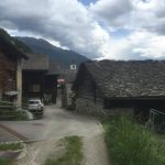
June 11 Isone to Lugano 23 km A word about the Restaurante Vedeggio in Isone. I have met so many friendly accommodating people on my walkabout, but Daniela and her staff were amazing. The restaurant was full of Isone soldiers (there is a base there) and some locals, but they made every effort to make […]
June 10
June 10 Biasca to Isone 36 km Today I invoke the excessive mileage, short blog-post rule. I wanted to position myself to get into Lugano tomorrow, and the first 20 km was flat, so I did 36 km with the longest climb (except for Gotthardo pass) of the whole trek. In other words, ahhm beat. […]
June 9
June 9 Lavorgo to Biasca 25 km This morning I witnessed something I had never seen. In Nepal, I often encountered woodcutters who not only chopped the trees down with short, curved-bladed axes; they also cut the boards by hand in pit-saws. This morning I watched a helicopter fly back and forth bringing entire cut […]
June 8
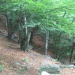
June 8 Airolo to Lavorgo 29 km The unstated rules of trail designers are keeping trekkers off of paved roads as much as possible, generally avoiding large towns (unless the trek is a religious pilgrimage), and maximize opportunity for amazing views. Following those rules closely can produce uneven success. Avoiding pavement can at time lead […]
June 7
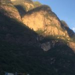
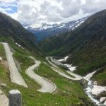
June 7 Hospenthal to Airolo Crossing a high mountain pass always brings a sense of anticipation. Inevitably the path follows a river which dwindles with the altitude gain. All the while walking, you look at the steam knowing you cannot cross over until it becomes the merest trickle. Gotthard pass is riddled with tunnels, […]