Walking Home

reveries of an amateur long-distance hiker

Walking to the Smoky Mountains, Day 20

June 17th, 2021

Walking to the Smoky Mountains, Day 20, June 17

Pole Road Campsite (55)  to Bryson City

The day opened in reluctance. I knew I had a 13 mile walk out to get to the road to hitch to Cherokee NC, so it wasn’t a simple stroll, though it was the end of a very long trek (250+ miles in these mountains is no joke). I geared up for the last time, following the rituals of the summer—those that sustain hiking and peace of mind. I had camped in a place where three different sites were closely connected, so soon after setting out, I was passing a site where three men were just about to start their trek out. Ryan, Jake, and Steve— three men finishing a three day fishing, hiking, camping trip— were on their way to the Deep Creek parking lot to head back home to Columbus Ohio (except Jake who was heading back to the main-line near Philly). They happily agreed to drop me at Bryson City on their way to Asheville, so, for the first time in many years, I fell into a walk with three other trekkers, alternately talking and walking in a gregarious and pleasant way— each was a really interesting person to walk with, so the miles melted away and soon, after seeing a number of waterfalls and watching the kids tube down the river,   they dropped me at the Relax Inn in Bryson City. The perfect spot to end this long Benton Mackaye Trek.

T. Hugh Crawford


Walking to the Smoky Mountains, Day 19

June 17th, 2021

Walking to the Smoky Mountains, Day 19, June 16

Chambers Creek (#98) — Pole Road Campsite (55)  22.5  miles

Right up to the end, a perfect hiking day. I remember moment in Earl Shaffer’s Walking with Spring when he describes how he hit a point where he ate twice what he had been eating. Long distance hiking burns huge calories so there is a point a few weeks into a trek where most of your body fat is burned off, and you have to increase consumption (though you can never keep up as long as you trek hard). I doubled my food last night and woke early (5:30) ready to go. I knew if I were to get in position to finish Saturday, I had to make up miles that my Smoky Mountain permit didn’t support (all part of a not particularly intuitive website inflicted on my schedule).  So my goal was a good 4 miles past my scheduled campsite, and more if possible.

Another experiment was coffee. I had packed some Starbucks instant just in case I wanted to fire up the jetboil stove in the morning before starting. That impulse never materialized (in part because I didn’t have any of that sweetened condensed milk in a toothpaste tube that they sell in New Zealand— a backpacking item worth its weight in its weight). So I dumped some packets in my nalgene for the early morning walk (I did feel a certain spring in my step.

As I said, a nearly perfect hiking day. The Smokies are in some places, incredibly isolated and untouched, but this area shows signs of long habitation, with most paths following what were some decades ago, primary roads to communities, so the trail was usually well-graded and a fast walk (necessary as I walked almost 23 miles). After miles of horse prints and piles of horse shit, I did finally meet two men astride soem amazing animals, so glad to see people following these traditional paths on the critters that made them.


The flowers were also getting dominant. Every shade (and of course the occasional “almost” ripe blackberry regularly appeared, as did, of all things, a long stretch of Day Lilies (the orange kind) lining the path.  I remember wilderness paths in Virginia near West Virginia as a child where those lilies also appeared which I guess is why I’ve never thought of them as a home garden flower. And as always, there were many streams with opportunities to re-water.  Much of the day was on Nolan Creek, a favorite of fly fisherman, and well worth the trek. One thing that struck me when filling my nalgene was the odd bass-drum thump that plays on the stream by the water in sudden holes in the streams. A fascinating symphony.

I made it to Bald Creek camp— which was further than my itinerary—by 3:30 so I decided to push on to the next site which was 4+ miles. Definitely my longest day if the trip, and of course the smooth trail I’d been on all day turned to a narrow, rooty, steep climb. Undeterred as I still felt good I continued on until I ran up on a huge timber rattler. He was coiled across the trail and I didn’t  see him— just heard. First response was to leap away, which was on the downslope side of the trail. There I found myself laid out prone, but I could see the rattlers— at least 10 pairs—shaking insistently. I scrambled to get up, only to discover my backpack was caught under a downed tree, so I watched to see if the rattler moved while I unstrapped in order to move on. Fortunately he stayed coiled— he was much bigger around than my biceps (maybe closer to my calves for those of you who need anatomical metrics). I made my way past his rattling circuit, stopped for a moment to consider getting out my iPad for a picture, then realized the snake needed his dignity too, so I proceeded on to the Pole Road Campsite— another completely empty one, to settle in (after 22.5 miles) for a good nights sleep.

Unfortunately that was interrupted by inspection of my long-sore toe which had now blown up to full-fledged infection. There I had to make the decision to abandon the trek just a two-day walk from the end, but a merit badge is not worth compromising health. My last night on the trail (and the last night in my ZPacks soloplex tent— a tent I’ve pitched on every continent except Antarctica— is now to be retired. The fibers after all those pitchings are now stretched thin (moment of nostalgia)). An uneasy sleep after what had been a glorious day of trekking. At least it was an evening of lightening bugs, a bright moon, and flood of stars— all observed because of late evening micturation.

Walking to the Smoky Mountains, Day 18

June 17th, 2021

Walking to the Smoky Mountains, Day 18, June 15

Procter Fields (#86) — Chambers Creek (#98) 15 miles

The humidity dropped, so apart from some general malaise (just feel like I’m running out of gas), today’s walk was excellent. Relatively steady altitude with sweeping curves up into the coves, rock hopping a spring or stream, then long moderate climb to cross the next ridge. There were none of those points where a steep climb made me sweat through everything and have to put my (already in waterproof case) phone into a plastic bag to avoid sweat-short.

The first bit was on the old turn-of-the-century railroad bed. Rails and ties were taken up long ago, but the bed remains in good condition. Later in the day, I was consulting the Guthook navigation app about upcoming waypoints, and was puzzled that they were all at the same attitude. Later when I got to that part, the trail joined that old railroad bed for most of the afternoon. The Lake Fontana can be seen through the trees, just a few hundred feet below. Was thinking about what it must have been like riding the logging train out from Procter, then realized that the train stopped running before the lake was built, so that was not their experience even as it was mine. I remember reading that, before the chestnut blight wiped out most of the forests here, a National market for American chestnuts was developed by running narrow gauge trains up into the Appalachian coves. I wonder if that train was part of that commerce.

Trying to plan out the end of this trip, and the last days will be brutal— several 18 milers ahead and the ascent and descent will be steep and long. Will just have to see how things hold up— I can abandon over near Cherokee if necessary.

T. Hugh Crawford

Walking to the Smoky Mountains, Day 17

June 17th, 2021

Walking to the Smoky Mountains, Day 17, June 14

Fontana Shelter — Procter Fields (#86) 12 miles

The Smoky Mountain Park service requires permits and a specific itinerary. To finish by Saturday, I need to walk 15+ days, but filling out the form, I dropped five from first day, so my day was as pleasant and pressure-free as possible. Leaving from a shelter (that has a bathroom) is much quicker than striking a tent and digging a cat hole, so I was crossing Fontana Dam at 6:30. Beautiful morning. In the initial days across the Smokies, the Benton Mackaye follows the Lakeshore Trail, which, as you would imagine follows the northern shore of Lake Fontana, ducking down to some of the coves, and climbing up around the various micro-watersheds. As the people I met yesterday who had just walked this section told me, water is plentiful, so even though it was hot, there was no danger of dehydration. And I even stumbled on a patch of early-ripe blackberries.

The path is also designed for horses, which generally means a wider, smoother surface with climbs at a reasonable grade. (That is what makes  long miles on the Pacific Coast Track possible). Much of today’s walk was on old logging or transport roads, particularly as I approached Procter.  Though this area seems long-empty, around the turn of the 20th century, Procter was a logging boom-town with a population over 1000. Today, apart from the road, the most conspicuous evidence is one building—the Calhoun House, built in 1928 and maintained (somewhat) by the Forest Service. In the miles around Procter you can see the remnants of old cars (straight out of Bonnie and Clyde), an old stone mill, and a range of rusting metal debris. I will need to check to see if someone has written a history of this area. It has the poignancy of post-chestnut blight, depression, and federal buy-out darkness about it all.

The GSMP campsites are spacious—I currently have one to myself,  so I took a dip in Hazel Creek, spread my stuff out to dry, and spent a quiet afternoon shooing the flies away.

T. Hugh Crawford

Walking to the Smoky Mountains, Day 16

June 17th, 2021

Walking to the Smoky Mountains, Day 16, June 13

Old Road Bed —Fontana Village—Fontana Shelter 12.7 miles

Except for the lack of water, the old road bed was a good campsite. My tent was pitched so I could watch the sun go down, and a light breeze made for good sleeping. I was up early looking forward to hitting a version of civilization again (this is a busy stretch for towns, etc. ) Initially the trail was clear, but very steep. A lot of turkeys stirred as I passed—a day of ridge hiking straight up and over each knob.  A few hours in, the maintenance gave out and once again I had to plow through greenbrier, poison ivy, and immature trees. I’ve always loved maple trees, but that affection is being tested. I only had a 1/4 liter of water, so I knew I’d be cutting it close. Compounding that, I made a couple wrong turns at an electric meadow road, which put me back an hour— the trail entrance I kept missing was completely overgrown and not well-marked. That seems a characteristic about this part of the BMT.

Happily there was a spring about a mile from Fontana, so I rehydrated and headed into get my Smoky Mountain hiking permit—a singularly frustrating experience since, even though the lodge provides a computer, the GSNP web site is, to put it mildly, crap. Of course the idea of intuitive understanding is often specious, but the various stages are minimally obvious. It took almost two hours to finally get my pass printed, and it’s not the itinerary I really wanted. (Lots of difficulties including not having cell service compounded all this.). Then I learned there is a shuttle from the lodge to the shelter, so I spent a quiet afternoon at the bistro, eating a big salad and drinking a few beers. Great bartender took care of all my needs, and a couple from north Georgia who just hiked much of the stretch I’m heading into were very helpful with suggestions. It was one of those rare afternoons where relaxation, information, and nutrition came together for a moment.

The shelter is a crossroads for AT hikers. It’s too late in the season for thruhikers this far south, but this crew is definitely AT. The first night since my first that anyone has been in camp with me. There are no grass or dirt tent sites, so I’m going to sleep in the shelter with a bunch of hikers. For now, I’m reading, listening to their intense conversations while they cook. So much talking! The crew in the shelter are older men who clearly prize their comfort sleeping (if not hiking) as they have huge packs, loud inflatable sleeping pads, and sleeping bags that would float a king. An early sleep was not in the cards. Hope for a quick quiet exit in the morning.


T. Hugh Crawford

Walking to the Smoky Mountains, Day 15

June 13th, 2021

Walking to the Smoky Mountains, Day 15, June 12

Bobs Bald to Old Road Bed 13 miles

Yesterday evening it looked for a moment that the sun might finally break through the fog, but instead the wind picked up and the temperature dropped. Shivering, I had to shelter early in my tent, digging deep into my sleeping bags or the first time on this trip. Soon the lightening came in with the thunder and it poured all night.  Everything stayed more or less dry, but it’s all damp as usual (makes the pack heavier).  The morning hike down to Tapoco lodge for lunch before continuing should have been a walk in the park. Instead I had 11 miles, most in fog and damp, with an overgrown trail— blackberry bushes as high as my head—glad they weren’t ripe given the bear situation. I couldn’t see the trail itself which makes for slow going as did the 7 miles down of washed out path, carefully picking my way down.  Was exhausted by Tapoco, but stopped for mid-afternoon lunch. The place, like everywhere in these hills, was dominated by older motorcyclists. They form a dominant part of the economy.  I relaxed a bit as the sun finally began to dry things off, then headed another two miles to get a bit closer to Fontana Village where I will resupply, and get my smoky mountains camp tickets, in prep for the final push. What a difference a day makes— the tent is hot tonight.


T. Hugh Crawford

Walking to the Smoky Mountains, Day 14

June 13th, 2021

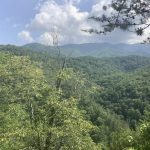
Walking to the Smoky Mountains, Day 14, June 11

Tellico Plains/River to Bobs Bald 15.4 miles

Except for the last two miles, I couldn’t have had a better trail for the day’s conditions. Misty rainy all day very little visibility—walking across on of the numerous balds in these ranges, the fog obscured my view of the blaze markers set out to lead hikers through (at a distance I mistook a clump of daisies for a white diamond, but as it turned out they were perfectly placed). North of Tellico River the BMT maintenance crews have been active, so the path wasn’t overgrown (except those last two miles), which really made a difference as I was trying to keep my beat-up feet as dry as I could, a nearly impossible task given how much water is running out of these mountains. I’ve never seen so many streams and springs—little waterfalls, perfect places.  And all that water supports amazing stands of now older trees, many with lower trunks carpeted in green moss. And of course mushrooms of all sizes, shapes and colors. In one area of downed logs, there were shelf mushrooms that looked like mussels growing from the wood.

Most of the middle of the day was following the same ridge as the Cherohala Skyway, a road incredibly popular with motorcycle riders, even on wet foggy days apparently, so things did get pretty loud at times. It reminded me of hiking the Appalachian trail with Bennett in this part of Tennessee and later in Virginia. You could always tell it was a weekend by the roar of the motorcycles. Of some concern are the bears the maintenance folks I met last week warned about. These next miles are a hot spot for bear activity— there are even a bunch of temporary signs tacked up at the trail intersections warning about them. I’m up high on a ridge miles from anyone, so used extra caution hanging bear bag high and far from camp. Let’s hope for a peaceful night’s sleep.

Walking to the Smoky Mountains, Day 12-13

June 10th, 2021

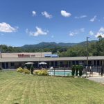
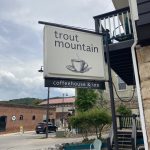
Walking to the Smoky Mountains, Day 12-13, June 9-10

Zero Days at Tellico Plains

Tellico Plains is a small town with a big heart, and none are bigger than Lance and Cheryl’s, the proprietors of Trout Mountain Cafe and Inn.

After arriving I soon realized either I take some time to heal up, or I’d have to abandon the trail, so I added a day and have spent most the time slowly taking care of little details—resupply, laundry, eating pizza at the Tellico Grains Bakery, but mostly drinking lots of coffee with Lance, Cheryl, Ammon and Sydney. Particularly good conversations with Sydney who is finishing a PhD in folklore at Ohio State, studying Tennessee vernacular architecture (among other things), and Ammon who both dives and pilots semiautonomous submersibles in the Gulf of Mexico.

But what I will likely most remember is that Jackson Browne’s music is alive in well in Tellico Plains— I did not walk into a single establishment playing music without one of his songs soon queuing up. Felt like college years.

Here’s hoping the feet are tough enough to continue tomorrow.

T. Hugh Crawford

Walking to the Smoky Mountains, Day 11

June 9th, 2021

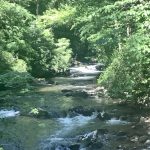
Walking to the Smoky Mountains, Day 11, June 8

Sandy Gap — Tellico River 15 miles

In the middle of the night, the rains came in, and I had that moment of satisfaction being in a well-pitched, well-designed tent. Just had to check around the edges to be sure nothing leaned on the tent “tub”, then lay back to listen to the drops. By morning the clouds had moved off, and even with the typical early fog (after all, I’m close to the Smokys) it looked to be a clearer day than the last few. And of course, I’m on my way to town, a hot meal and a soft bed.

This was an interesting stretch. I’d stayed in a more or less dry camp (feet hurt too bad to seek out possible water 1/4 mile away). As it turned out, water was no problem after about 6 miles as the trail crossed and recrossed Brookshire Creek all morning. A fascinating watershed where dozens of small streams fed the creek up fairly high on the mountain, making quite a torrent all the way down the ridge. Guthook labeled a number of crossings as “fords”, but thankfully only one (at the top of a wonderful falls) actually required wading. The others I crossed rock hopping. The afternoon was a climb up the Bald River watershed (the river of the famous falls), followed by a fast descent to the Tellico.

And after a week and a 1/2, I finally encountered another thruhiker— actually two— heading southbound a few miles apart.  It highlighted just how solitary this trek has been. After my first night at Three Forks, I’ve been the only tent in any campsite I’ve pitched in (except of course the mystery empty tent back at Halloway Gap). The first was a man probably about my age who had to abandon the BMT last year midway (something these blisters might require me to do) and was now doing the second half. Nice man. Then I bumped into a serious hiker from Birmingham who has done many trails in these mountains including the Pinhoti last year. Clearly fit and experienced, we had a brief but good talk. There’s much common understanding between experienced trekkers that forms a baseline for conversation.

I’d like to think today was a short day, but measured out at 15 miles, which has been pretty much the total for most days. I got to the Tellico Trail Head at 2:30, and by a little after three, Jacob (the guy who Lance, from Trout Mountain Inn had recruited to pick me up) arrived, and soon the miles were ticking by at an unfamiliar pace as we made our way to Tellico Plains— a small Tennessee town where most of the main businesses are out on the highway, but with a couple of blocks of old downtown with classic old storefronts which is where Trout Mountain is located. Lance, Cheryl, and Ammon are wonderful and interesting California transplants who make some of the best coffee I’ve ever tasted. Before shedding my shoes, I trudged out to the strip mall to get resupplied, pick up some beer and a gallon of lemonade, along with an early dinner at The Bears Den pizza place— another kind and interesting cook running the place.

Feet still brutalized, but a satisfying day, and a good place to rest up.

Walking to the Smoky Mountains, Day 10

June 9th, 2021

Walking to the Smoky Mountains, Day 10, June 7

Coker Creek to Sandy Gap 17.5 miles

In past long-distance hikes, right around the seventh or eighth day, the world of work and obligation fades to a distant place, and then I have wonderful and interesting conversations with myself while walking that long path. Something always prompts a revery or a memory worth thinking through.  I dunno, maybe it’s pandemic hangover, or maybe the rigors of this trail (it can be difficult), but I have yet to find a rhythm that brings solace.

Today was long and in the rain. Mostly ascent since the Hiawassee is the low point of the trail. The climbs didn’t bother me, and the rain kept it cool, but it was something of a plod. Fortunately on arrival at Sandy Gap, the rain stopped, the wind freshened and the sun came out. Now at least everything is just damp instead of soaking wet. Tomorrow I head to Tellico River, then get a ride to Tellico Plains for resupply and a zero day.