Walking Home

reveries of an amateur long-distance hiker

August 9

August 11th, 2015

image


August 9 Campsite to campsite 20.8 miles 7:00-5:00

Switchbacks!
This was a killer day. Started early with 3 mile climb, some flat up over 6000 feet, then a really long climb down — all switchbacks (it was like going through airport security in Atlanta). Had lunch on bridge at bottom with Ladybug and Crow, then a brutal climb in the hot sun up over another ridge. We made a third of a circle around Glacier Peak. It was completely beautiful but totally exhausting. Had to water up 1.5 miles before the finish as it was a dry camp. Nothing like carrying 3 extra liters at the end of a 20+ day. Ahmmmm tarred.

August 8

August 11th, 2015

image


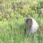
August 8

Sally Anne Lake to campsite by stream 17.79 miles 7:30-4:00

Marmots, Ground Hogs, and Grouse

It just keeps getting better. Day started with long traverses, we could see the trail ahead for miles across broad valleys. Once more, lots of blueberries. Kept getting closer to Glacier Peak, and saw many other ice capped peaks as well. Today was different in that we were on terrain that often resembled English moorland– with grouse, but not heather. Instead blueberries and lots of wild flowers. Ideal grouse habitat, and we scared up plenty and heard more. Also saw herds of marmots (what is the term for a group of marmots?) I’m not sure, but these silver gray critters look and act just like the groundhogs I grew up with in rural Virginia. They are fearless, sitting on hills watching us hike by. When we finally rounded the range we were traversing most of the day and came over a saddle –Red Pass–we saw this magnificent bowl shaped valley, upland moor habitat on one side (with plenty marmot/groundhogs ) and the other all rockslide, imposing. Later in the afternoon we made our way into a valley full of glacial streams, met some thru hikers–Crow and Ladybug–then wandered through huge forests and areas that resembled Maine, with large rounded boulders covered with deep coats of moss. Toward the end we stopped at a stream that looked like milk– so full of minerals. Earlier in the day we were talking with a women we met at a water source. Bennett had said in the Half Mile Guide, some of the streams were marked as silty, and she, meaning to say “it’s just glacial melt” said instead “glacial milk,” which turns out to be an apt description. Made camp up a draw near a glacial stream that was only a little milky, weary but smiling.

August 7

August 11th, 2015

image


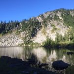
August 7
Pear Lake to Sally Anne Lake 11 miles (not counting detour) 7:30-2:45

Lost and found, Maximum Blueberries
This was a day for the ages. Slept by Pear Lake. When we had come in on a side trail, there were lots of people camped in a single flat spot, so we walked to the other end of lake where we found a site by the water. Bennett found a PCT sign on the trail just up from us, so we would not have to back-track to get on trail in the morning. Very cold and ultimately wet night–dew soaked everything. We didn’t get started until 7:30 but had good hour hike up and down. When we got to a cross trail, Bennett scratched his head. It was clear we were not on the PCT. From where we stood, we could see what we thought was the PCT high on a ridge across the valley (you can often pick out the route of the trail at a great distance, lines drawn on the side of mountain). At the crossroads, there was a trail marked “abandoned” that looked as though it went there, so we decided to chance it rather than backtrack. It was still easy to follow (at first), parts were over grown and difficult, but it was heading in the right direction so we pressed on. When we got halfway up the ridge it fizzled out. Occasionally we could find faint bits of it, but we were mostly in blueberry brambles (the first and last time I spoke ill of that noble bush). Finally we had to bushwhack straight up the ridge, concerned that we may have overshot the PCT or that it would have dropped over the other side of the ridge too far down to find. We kept comparing our two maps, but neither were conclusive. After a hard struggle we gained the top of the ridge and right in front of us was the trail. Exhausted and soaking wet, we spread out sleeping pads and baked in the sun for a bit. Decided to hike short the rest of the day, so we ended up with an official 11 miler, also by a lake. Expected cold later that night, but for now we have all our stuff spread drying in the sun, grateful for an early end to a ridiculously difficult day.

August 6

August 11th, 2015


image


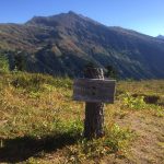
August 6 Stevens Pass to Pear lake 18.6 miles. 9:15-5:15

Pine-cone blossoms, and blueberries

Slept in at Cascadia Hotel, then headed over to the deli for breakfast–biscuits and gravy–but just as we got our meal, a nice couple in a pickup truck pulled out, we asked for ride and had good conversation with the woman who had grown up in Skykomish and who collected old quilts and a man who was a retired contractor. We sat on the ski lodge steps and ate our breakfast then headed off on the next leg of the trek. Initially planning about 10 miles, but the magic of biscuits and gravy, a trail that started the first two miles as a railroad grade, and general lightheartedness got up to that lake by one o’clock. We made good time, but stopped and talked to a whole lot of people, mostly day or overnight hikers, but all experienced and knew the area well. Most of the day the trail was in the woods with incredible surface, made for good trekking. After we pressed on from initial campsite, we had more elevation change and water got scarce. Ended up having hike to full 18.6 to Pear lake which is beautiful, but we were gassed when we finally got here. Camped by the lake again but probably for the last time. Exposure to the wind, which makes for cold evening meal prep and diving straight into sleeping bags for warmth. BUT we are in a field of blueberries (bear bait?) very satisfying day.

August 5

August 11th, 2015

image


August 5
Trap Lake to Stevens Pass (to skykomish) 11.3 miles 6:45- 11:45

Bitter cold night, wind whipping off the lake drove both of us into the tent by 7:30– very small tent, but was necessary. Visited by deer, didn’t see them but recognized their step and snuffle. Up early for the run to town– could smell the barn — fairly uneventful hike, bumped into a lot of hikers, good conversations. Learned more about the fires up north which will definitely affect us. Arrived at Steven Pass ski lodge, had ice cream, talked to some south bounders who knew something about the fire, exchanged our old data for their map of the north section– good trade. Skykomish is 15 miles away so we needed to hitch. Picked up by two reporters from Everett — Ian and Gail– who were working on a feature article so they stopped at some attractions on the way– a railroad installation and a waterfall. Ended up eating lunch with them at the Cascadia Hotel restaurant. Looks like we will be part of their article. Spent afternoon getting resupply box, figuring out the next section in relation to the fire, getting other resupply and sorting it all out. Had dinner at the same hotel restaurant because it is the only game in town. Then took advantage of the wifi to answer emails and went to sleep very early.

August 4

August 11th, 2015

image


August 4
Deep lake to Trap Lake 18.3 miles 7:15-4:15

In the middle of the night I heard the rustle of a large animal. We haven’t been hanging bear bags, just using supposedly bear-proof bags and hanging them on the side of tree 100 feet from camp. I was cowboying it and heard distinctly the crash which had to be a large animal, woke up Bennett who was in the tent, got my light and saw a large buck walking through our camp. He didn’t scare when I spotlighted him, just ambled through and when I was about to fall back asleep, he came back. The stars were amazing just then, the moon rose later nearly full. Had a long climb up to start the day– was a day filled with lakes and other hikers, kept running into people, some more talkative than others. Did learn there will be detour in the next section because of forest fires, but we’ll have to weigh options when we get to Skykomish tomorrow. Tonight we camped beside a beautiful lake, perfect spot except the wind has really picked up and it is very cold. This is amazing country.

August 3

August 11th, 2015

image


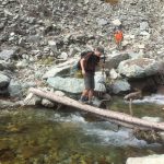
August 3
Lemah Creek to Deep Lake 21 Miles 7:00-4:00

So we had joked about hiking 7 miles day 1, 14 Day 2, so 21 day three, which actually turned out to be what we did. Started the morning planning 16, but after a very long but beautiful climb where we could see glaciers feeding waterfalls, then had second breakfast by a high mountain pond followed by a very long decent into a valley with a large lake. The trail was smooth, had blueberries again, not nearly as many rock crossings. Lunch beneath a big bridge with an ice cold stream beside– I soaked my hot blistered feet. We realized we would be at our projected camp in an hour, and that deep lake was only another 7 which we managed in about 3 1/2 hours. Camped near beautiful lake–I jumped in even though it was ice cold. Felt good to wash off all that sweat and dust. Very little rainfall here, so the dust is constant. We settled in for some quiet reading–getting a good rhythm. Tomorrow will be long but not like today.

August 2

August 11th, 2015

August 2

Gravel Lakes to Lemah Creek 13.5 miles 7:30-2:30image

Fairly hard day– still don’t have hiker legs. Got up early, but didn’t hike until 7:30. Had breakfast with Kate, then she headed back to the pass, and we spent a big portion of the morning climbing, with lots of rocky traverses across scree from landslides. The scenery was magnificent but the trail narrow and rough surfaced. Lots of hikers, the ones out for extended time are doing the Snoqualmie/Stevens hike which is our first section. Water was scarce most of the day, the drought has dried up the little rainwater ponds. We did see lakes in the distance but the trail did not go to them. Blueberries, lots of blueberries. When we started our long descent into the Lemah creek valley, many many switchbacks, we passed a guy who had his gear packed on a wheelbarrow. He seemed quiet and calm and methodical but must have been taking a lot of gear and food. Have heard of hikers doing that, but have never actually seen it. The first water we encountered was this great waterfall, so we stopped for lunch. Met Carl and Erin Miller who are finishing the PCT. She wrote the Hiker Trash on the PCT book, and they will be doing the Te Araroa later this year. Stopped early, Camped by a stream where the bridge had washed out, good water, nice spot, though the yellowjackets swarmed when we opened a pack of tuna– lesson learned.

August 1

August 11th, 2015

image

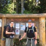
August 1.

Snoqualmie Pass to Ridge and Gravel Lakes 7.2 miles 3:00-6:00

Started morning in the Cabbagetown house, gathered our things, set off some flea bombs, and headed to Marta and the airport. Smooth transportation there, arrived in Seattle by noon, and our friend Kate was there to pick us up. We three headed east out of the city toward the Cascades, always it seemed in the shadow of Rainier. Stopped at cute town called Issaquah and had wonderful seafood brunch, getting to Snoqualmie pass mid-afternoon, and after some equipment prep, hitting the trail at 3. Hiked 7 miles, all up hill to the Edge Lake. Trail is incredibly well maintained, and no really steep grades, though it was a hard seven miles (first day out always is). At times really hot, but also chilly. Lots of campers spread out across some nice grassy sites. We set up, I cowboyed it – no humidity here, little chance of rain. Made dinner and Kate surprised us with beer, avocados, fresh vegetables, now that’s a good friend. Talked a while but jet lag and exhaustion soon overtook us. Slept well though it was chilly and windy–it is great to be back outside.