Walking Home

reveries of an amateur long-distance hiker

Day 97

December 8th, 2015

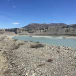
Dec 6 day 97 Lake Middleton to free camp, south of Ahuriri River 7:00-6:30 30 km (plus 7 km off trail to hike around river to bridge).

image

Today I was once again a walker of rivers, unfortunately not a forder of rivers which made for a long day’s work. I woke with a vague sense of dread. The descriptions of the day’s trail were not promising, making it sound as if navigation up on the saddle and down the East Branch of the Ahuriri would be difficult with no real trail to follow and markers few and far between (I was remembering the difficulty around Coal River last week) And there was a ford at the end of the day– the largest unbridged river on the trail. And it was cold and wet, some rain falling as I headed up the road to the trail head. The hike initially was uneventful, the mist cleared and the trail was a 4 wheel drive road so the grade was easy. Then it turned up into the pass, following up a roaring stream through a huge beech forest. It was magical and my bad temper lifted immediately. Just before the trail broke out of the woods above bushline, I stopped by the stream at a big rock, got out the Jetboil and made oatmeal and coffee, then just relaxed, taking in the beauty of the place. The rest of the ascent was steeper and rockier, but good, and before noon I was over the saddle and on my way down a well-marked and easy to follow trail. The river was beautiful and so was the day. After a bit, the trail stopped crossing the stream and climbed a ridge where a large flat plateau opened out, a space worthy to be the set of a Sergio Leone film. This area is high desert– a lot of water is flowing through it, but the soil is thin and rocky. The bogs have masses of moss and springy grass, and the edges of the streams have some bushes and of course spear grass, but on on the plain the vegetation is crispy and thin except just now the dandelions are blooming by the millions. They are different from the ones I know, the leaves are small, thick and have no lobes. Instead, they spread out touching the ground so there is no wind desiccation. They get maximum sun and hoard moisture, waiting for the beginning of December to thrust up a single bloom on a two inch stalk. It was all yellow today. Late in the afternoon, the valley I was descending broke out into the main river valley. It was all broad flat plain except for a pine plantation on one side. It took a good hour just to cross the wide flat space (I was slowed a good bit by dodging rabbit holes– they are everywhere here). When I got to the river, my plan was to ford and camp just on the other side– a good 30 km day– but, around 4:00, I arrived to discover a high and fast running river. To the west I could see a range of snow capped mountains melting fast in the day’s hot sun. The river was milky green, so full of glacier melt that I could not see the bottom. I made several tentative forays into it, trying to get a good foothold and then cross, but each time I’d get about 1/4 the way across and the bottom would drop out, making it impossible to cross in the current. The TA paperwork says that when the river is too high to ford you should head downstream 5 km and cross by a bridge. So off I went, first in the rocky river bed, then up an a small ridge but making good time. I was still in a good mood. Then the Ahuriri did what all rivers here do– it swung over to my side and crashed hard against a cliff, making walking impossible. There was a high ridge above (about 100 meters nearly straight up) that formed a flat plateau with a lot of pine trees. I had no choice but to climb up there, weave in and out of trees, sticker bushes, pasture land, climbing numerous barbed wire fences, fording dozens of streams, finally getting to the road that led to the bridge. It was 6:00 before I crossed, too late to try to get back to where I originally planned to camp, so I walked up the road a couple of clicks until I found a stream and a flat place for my tent. Going to sleep well tonight.


Day 96

December 8th, 2015

Dec 5 day 96 Twizel to Lake Middleton Campground 8:15-3:15 29 km

image

Following my rule not to eat out of my backpack when a restaurant is available, I wandered around Twizel a bit before getting the big breakfast at the Hydro Cafe, so-named because this whole network of lakes and canals in this area is a massive hydro project, with Twizel right in the middle of it. Twizel itself is a strange town. I’d like to learn the history. There are a number of buildings that are older (not old) including the High Country Motel and Backpackers where I stayed, along with the Top Hut Sports Bar immediately adjacent, but the entire downtown looks as if it was designed and built just a couple of years ago (along with the inexplicable presence of two 4 Square grocery stores within a block of each other). It all has a recently designed feel to it, and one that does not follow the typical New Zealand small town which inevitably is made of two streets crossing perpendicularly and lined with a bank of storefronts. Twizel’s business district faces a square with a playground. After breakfast I headed out for another day of road/bicycle path walking, going first to the dam across the base of Lake Ruataniwha– a man-made lake that is part of the hydro system and also the site of rowing competitions. I saw several boats out practicing in a strong headwind as I walked up the shoreline, but first I stopped at the salmon farm, not to feed the fish which apparently is a big tourist draw, but to get a last cup of coffee before heading off into the bush for 4-5 days. The day’s walk was uneventful, first following shore of Lake Ruataniwha, then the Ohau River, and finally the Lake Ohau, arriving mid-afternoon at a DoC campsite with few amenities, a high site price, and a lot of sand flies. Still, I had hiked nearly 30 km and thought calling the day early was a wise choice. Had a great conversation with an enthusiastic fly fisherman named Frank, cooked dinner, and dove into my tent just ahead of the sand flies.

Day 95

December 4th, 2015

Dec 4 day 95 freedom camp on Lake Pukaki to Twizel 7:00-12:30 29 km

image

There are mornings when I just want to stay zipped up in the sleeping bag. This morning the wind had stopped, the sun was bright, but the temperatures were still cold. After 40 km yesterday, I just wanted to stay in the tent, but Twizel beckoned, so I was up and out for another day walking gravel roads, today’s difference emerged when I rounded the corner of the lake and could look back at Mount Cook and the Nun’s Veil completely covered in snow. It was jaw dropping. The trail was soon following the alps to ocean bike path, through a camping area where I sat down at a picnic table, got out the Jetboil, made coffee and just stared at Mount Cook. The path later crossed the dam at the end of the lake where I could look down at the milky deep blue water, a color beyond description. Then it led through a young pine forest and finally across a dry bit of desert, not far from the set for the Lord of the Rings Plains of Rohan sequences, then into Twizel, a town that serves as staging area for various outdoor adventures. Picked up more supplies as the trip to Wanaka will take about five days. Warm sleepy afternoon, feet propped up and a Stoke IPA.

Day 94

December 4th, 2015

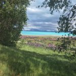
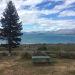
Dec 3 day 94 Tekapo Village to freedom camp on Lake Pukaki 8:00-4:30 40 km

image

When the boys were young, we used to read a children’s book called The Lupine Lady, all about a woman who bought big bags of lupine seeds and spread them all along the roadsides in the place where she lived. I had an idea what lupines looked like, but never had seen them growing in profusion until today. A long walk along a gravel road from Tekapo to Lake Pukaki, a glacier fed lake (near Mount Cook) that is milky turquoise. The Lupines were purple, but also turquoise, and even a shade of pink and orange. Very much a day of startling colors, which was a good thing as it was not the most interesting of walks– flat, rained most of the day, so the scenery was all fogged out. The best part is that I made excellent time, well-positioned to get into Twizel tomorrow– the last big town until Wanaka. I freedom camped on a ridge over the lake in a grove of beech trees. I hope they break the wind better than the site last night where the shaking of the tent kept me up much of the night.

Day 93

December 2nd, 2015

Dec 2 day 93 freedom camp to Tekapo Village 6:30- 2:30 30 km

image

Very simple straightforward day. I couldn’t get lost as the trail was clear (doubled as mountain bike trail) with plenty of pole markers. I do wonder how people who cannot see that particular shade of orange can negotiate the trail as often those markers are at quite a distance. The second half was a long walk along a gravel road (apparently what I have to look forward to on most of the next section). Still, the lake and the snow covered mountains sure made it a good walk. The hostel was full, so I tented (much cheaper and I usually sleep better in my tent anyway– and it had a million dollar view, all for 11$). Resupplied, updated my devices on the free wifi, had a very chill day.

Day 92

December 2nd, 2015

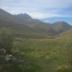
Dec 1 day 92 Stone Hut to freedom camp 7:30-5:30 26 km

image

Some days seem as if they a going to be simple, and veer off track in unexpected ways. I slept in a bit, in part because I was tired from the previous day, but also because I found Stone Hut comfortable– unsure why, I guess it was where it was sited, looking down Bush Stream as it bent around the knoll. In what seems now a requirement, the first thing I had to do on leaving was wade through that stream– and it was a cold morning. I had a lot of tussock hiking, still not my favorite way to spend my time, but by late morning I had gotten to the top of Stag Saddle, the highest point on the Te Araroa. On the way up I hiked through all these moss bogs, springiest surface I’ve ever walked on. The views up top were amazing, snow covered peaks with the desert below. The descent was a lot of scree, then a whole lot more tussock hopping. I got the hang of it I guess as I made it to Camp Spring Hut early afternoon, just as it started to sprinkle. That hut didn’t have the feel of Stone Hut, and the rain was light, so I decided to hike on and freedom camp at some point later on the trail (that had the advantage of shortening the day’s hike into town tomorrow). Not long after the hut, the trail began to follow the Coal River downstream. For the last two days the trails have been sparsely marked, so much navigation is by topography. I knew the trail would go with the flow of the river and so did not worry much when a long time went by without seeing a marker pole. They usually showed up a some point. Late in the afternoon, it had been very long since I had seen one and the river’s edge was getting completely choked by impregnable sticker bushes. The main trail had made a turn I missed and was now several hundred meters above me on a ridge. After briefly considering continuing on down the river, I opted for heading straight up the side of the mountain to regain the trail. An afternoon of getting really poked by stickers and an unexpected long hard climb was not what I had hoped for. On getting to the plateau above, I soon found the trail, a place to camp beside a stream and a gravel road, crawling into bed vowing to read my maps more carefully next time.

Day 91

December 2nd, 2015

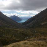
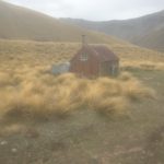
Nov 30 day 91 Bush Stream Car Park (from Geraldine) to Stone Hut 11:00-6:00 18 km

image

Late this afternoon I sat on a rock next to a stream drinking water that hours before had been snow. It tasted like snow. But that was not the best part of the day, which requires going back to last night. After I checked into the Geraldine Motels, I went up to try to arrange transport to the trail head– not an easy task as it is about an hour and a half from town, the second half on a seldom traveled gravel road (impossible to hitch hike). The Geraldine information center found a 4 wheel drive company who will make the trip, but the web site did not have direct contact information and they did not respond to my queries. Still, I was in a good mood because the town was so pleasant. They have the oldest purpose built movie theater in New Zealand, and across the street at the performing arts center I could hear dance practice going on. The restaurants, not elegant, but good. A town with a really good feel, and the owners of the motel–Ross and Sharon Mackenzie–are amazingly wonderful. She took me on a tour of some of the rooms, and when I came back from dinner, he caught me and offered to drive me to the trailhead in the morning. Classic kiwi generosity that never ceases to amaze me. After my breakfast at the cafe, we headed out. He took me through the back roads of his town, then the long drive up the river, eventually passing Mesopotamia, a station that was once owned Samuel Butler. Apparently he wrote early drafts of Erewhon there. We drove past the stone church built there for the people working at the station (and the owners who would have lived in a magnificent nearby house). The church had stained glass windows from England that were destroyed in the 2010 earthquake (the one that decimated Christchurch). The whole back wall of the church fell off. Still, an impressive little building surrounded by a graveyard and holly hedges, looks straight out of rural England. In a cloud of dust we arrived at the distant trailhead (I never could have gotten there hitchhiking). We said warm goodbyes, and I was off for a pretty hard day. The first part up Bush Stream which was high (mid-thigh) and running hard, making crossing tense, and there were many of them. There was no trail, just hiking pole marker to pole marker all day (even after getting off the stream) and they were often hard to see, so I had to trust I was heading the correct way. After leaving the stream it was up and over some high saddles, again, with no trail, just hopping from tussock to tussock avoiding the spear grass. This new desert terrain is not very forgiving and difficult to make time on. Got to the Stone Hut by 6:00. One of the walls is of stone, and it is surrounded by a rockslide. Here’s hoping they don’t decide to roll some more tonight.