Walking Home

reveries of an amateur long-distance hiker

Walking to the Smoky Mountains, Day 11

June 9th, 2021

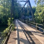
Walking to the Smoky Mountains, Day 11, June 8

Sandy Gap — Tellico River 15 miles

In the middle of the night, the rains came in, and I had that moment of satisfaction being in a well-pitched, well-designed tent. Just had to check around the edges to be sure nothing leaned on the tent “tub”, then lay back to listen to the drops. By morning the clouds had moved off, and even with the typical early fog (after all, I’m close to the Smokys) it looked to be a clearer day than the last few. And of course, I’m on my way to town, a hot meal and a soft bed.

This was an interesting stretch. I’d stayed in a more or less dry camp (feet hurt too bad to seek out possible water 1/4 mile away). As it turned out, water was no problem after about 6 miles as the trail crossed and recrossed Brookshire Creek all morning. A fascinating watershed where dozens of small streams fed the creek up fairly high on the mountain, making quite a torrent all the way down the ridge. Guthook labeled a number of crossings as “fords”, but thankfully only one (at the top of a wonderful falls) actually required wading. The others I crossed rock hopping. The afternoon was a climb up the Bald River watershed (the river of the famous falls), followed by a fast descent to the Tellico.

And after a week and a 1/2, I finally encountered another thruhiker— actually two— heading southbound a few miles apart.  It highlighted just how solitary this trek has been. After my first night at Three Forks, I’ve been the only tent in any campsite I’ve pitched in (except of course the mystery empty tent back at Halloway Gap). The first was a man probably about my age who had to abandon the BMT last year midway (something these blisters might require me to do) and was now doing the second half. Nice man. Then I bumped into a serious hiker from Birmingham who has done many trails in these mountains including the Pinhoti last year. Clearly fit and experienced, we had a brief but good talk. There’s much common understanding between experienced trekkers that forms a baseline for conversation.

I’d like to think today was a short day, but measured out at 15 miles, which has been pretty much the total for most days. I got to the Tellico Trail Head at 2:30, and by a little after three, Jacob (the guy who Lance, from Trout Mountain Inn had recruited to pick me up) arrived, and soon the miles were ticking by at an unfamiliar pace as we made our way to Tellico Plains— a small Tennessee town where most of the main businesses are out on the highway, but with a couple of blocks of old downtown with classic old storefronts which is where Trout Mountain is located. Lance, Cheryl, and Ammon are wonderful and interesting California transplants who make some of the best coffee I’ve ever tasted. Before shedding my shoes, I trudged out to the strip mall to get resupplied, pick up some beer and a gallon of lemonade, along with an early dinner at The Bears Den pizza place— another kind and interesting cook running the place.

Feet still brutalized, but a satisfying day, and a good place to rest up.

Walking to the Smoky Mountains, Day 10

June 9th, 2021

Walking to the Smoky Mountains, Day 10, June 7

Coker Creek to Sandy Gap 17.5 miles

In past long-distance hikes, right around the seventh or eighth day, the world of work and obligation fades to a distant place, and then I have wonderful and interesting conversations with myself while walking that long path. Something always prompts a revery or a memory worth thinking through.  I dunno, maybe it’s pandemic hangover, or maybe the rigors of this trail (it can be difficult), but I have yet to find a rhythm that brings solace.

Today was long and in the rain. Mostly ascent since the Hiawassee is the low point of the trail. The climbs didn’t bother me, and the rain kept it cool, but it was something of a plod. Fortunately on arrival at Sandy Gap, the rain stopped, the wind freshened and the sun came out. Now at least everything is just damp instead of soaking wet. Tomorrow I head to Tellico River, then get a ride to Tellico Plains for resupply and a zero day.

Walking to the Smoky Mountains, Day 9

June 9th, 2021

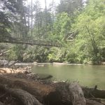
Walking to the Smoky Mountains, Day 9, June 6

Lost Creek tent site-Coker Creek campsite 16.6 miles

By far the most difficult day. It rained hard in the night and everything was wet, as was the trail. So even though the opening parts were easy flat walking, my feet were soon soaking and some blisters that had been bothering me blew up. The first few miles were on an old, overgrown railroad grade full of flowers and following a stream. I kept getting a whiff of cucumbers, which reminded me of the old story that pigs don’t eat cucumbers because that’s what snakes smell like. I question the veracity of that tale, but paid attention when the smell returned, looking for either a plant that smelled like salad or a serpent in the grass. Because of my early start I missed going to Webb’s store in Reliance—the town’s post office and all-around general store though I got to see the historic Hiawassee Meeting House in the early morning while the mist rose up from the river. I also took a half mile detour to eat breakfast at Reliance Fly and Tackle—another must-see fishing store with resupply and hot food— a couple of biscuits later I was heading back down the hill for a day that pretty much followed the

Hiawassee upstream. The river, which is also controlled by the TVA is a popular rafting and kayaking spot. Later in the day the trail wound up on some ridges above the river with large ledge rock overhangs. There I saw my first copperhead of the trip, and then realized the trail was a snake hunter’s dream, and so I proceeded with caution. Sore feet slowed my pace, but arriving in camp there was a little sun (but not enough to dry things out). To cap it all off, a semi-swarm of honey bees descended on my sweaty clothes and the outside of my tent. After getting stung, I had to zip in and wait until dark for them to leave. And of course, like any dinner party, two just kept hanging around.

Walking to the Smoky Mountains, Day 8

June 9th, 2021

Walking to the Smoky Mountains, Day 8, June 5

US 74- Lost Creek tentsite 13.5 miles

My ride was late leaving Ducktown (I should have gotten Bill’s number when he offered), but no matter. I had resolved to slow down a bit, try to enjoy more the details of the walk and not worry so much over time/distance/resupply. Yes, I’m out in the wilds with bears and snakes, but I’m not that far from civilization. Need to take each day like a long day hike (tell that to my backpack). As it turned out, my more casual pace was actually quicker than a deliberate pace. Amazing what can happen when you let your mind go free.

As I’ve mentioned before, the BMT is well-built and well-maintained, at least in the southern section. Today I crossed paths with a couple about my age with their son and grandsons doing a long dayhike. They are volunteer trail maintainers. Had a wonderful conversation about the the bears up ahead and plenty of good advice, including the strong suggestion that I take a zero day in Tellico Plains which is about three days ahead. It’s very far off the trail so logistics will be difficult, but with some early planning it might work out.

One difference between this stretch and Georgia is the age of the forest. I think much of today was in a designated wilderness area with some magnificent old trees—oak, maple, poplar, and pine with beech as understory (along with lots of others— the biodiversity of this area is legendary). There was a section with huge old pines, so of course the path was a bed of needles—good for my beat-up feet. Crossing one ridge a pair of pileated woodpeckers stirred up a ruckus. I’m guessing they had a brood in a nest somewhere, because they took turns swooping and chattering until I rounded the corner.

This area is under control of TVA, which is why the river rafting business is so good. When I passed the Ocoee this morning it was barely flowing, but the guy driving me said by 10 o’clock, after the water release, it would be raging. All that electricity they make with those power stations has to go somewhere, so the trail often crosses what Bennett always calls “electric meadows”—those trimmed (or even poisoned) fields beneath the high tension lines. It is at those points you learn how fundamental mature forests are to mitigate temperature. Similar to the electric meadows, today brought a few sections of fairly recent burnover (or clear cut), where ten foot saplings mirroring the species in the old forest—maple, oak, poplar—were each doing their best to become a new forest.

Walking to the Smoky Mountains, Day 7

June 4th, 2021

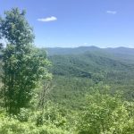
Walking to the Smoky Mountains, Day 7, June 4

Double Spring Gap to highway 74 (and on to Ducktown) 11.1 miles

Short hiking day—heading in to Ducktown to resupply for a 4 day stretch. A few days back I stopped to talk to a man (about my age) who was standing near the top of a mountain carrying nothing but trekking poles. He told me what to anticipate in the miles immediately ahead, mentioned some stretches he enjoyed, then looked down, gripped his poles tightly and said— “Big Frog, uh uh!” Last night I camped at Double Springs (a gap with a spring on either side of the trail, one in Georgia, one in Tennessee—I drank Georgia water that night). That campsite is at the foot of Big Frog, so my day started with the longest, steepest ascent thus far. It’s not like Roan mountain or some others on the AT, but it got my heart pumping first thing in the morning.

After those early exertions it was, as they say, all downhill from there. Long stretches of well graded and maintained paths, many, like Georgia, on old logging roads. Some of the ridges were steeper and paths narrower, so I relearned some caution I had not yet needed. The only excitement was a moment when I heard a crashing in the woods just down below the trail. An unseen mama bear making a ruckus, while I could see a small black bear cub climbing a tree. Wish I could have stayed to watch, but it was not all that clear where mama had gone, so I proceeded posthaste.

On hitting the highway near noon, I walked down to the Ocoee Whitewater Center (site of the 96 Olympics whitewater competitions) where it was easier to hitch a ride. A really nice truck driver named Bill picked me up and took me all the way to the Copper Inn, a motel recommended by the BMT guides. Nice folks who arranged transport back tomorrow morning. Ducktown is an old copper town, but the mines have long since closed, and nothing much has taken its place except seasonal river rafting. Even the Piggly Wiggly is closed, so I had to resupply at the Family Dollar. That experience helped me understand better the dietary challenges of rural America.

Much of the town is in disrepair and many of the shops are closed (I suspect covid has something to do with that). The bright spot is Rods Rockin Rolls— a restaurant specializing in Thai food and sushi, but (given the need for diversity) they also have an Italian menu. I spent the evening in their garden courtyard, sipping a beer and trying the fare. Was the highlight of the day.

T. Hugh Crawford

Walking to the Smoky Mountains, Day 6

June 4th, 2021

Walking to the Smoky Mountains, Day 6, June 3

Halloway Gap to Double Spring Gap 17.3 miles


Last night I was reading Suzanne Simard’s The Mother Tree— a section where she and a friend had to climb trees to escape a mother grizzly, not exactly the best story to be reading alone in the wilds of the North Georgia mountains. My sleep was undisturbed, but in the middle of the morning, while rounding a curve in the trail I found myself face to face with the biggest black bear I’ve ever seen. We briefly eyed each other, then he turned and ran up the hill. I’ll need to check on my appearance when I get to the next town.

It was a day of up and down. Started with a light rain, then sun, then rumbling thunder all afternoon and I had to trot the last three miles only to have the heavens open about 15 ministers from the campsite. I got the tent pitched in the rain, crawled in with all my gear, and waited it out. Between the rains, it was a beautiful day. Along with the bear, I ran up on an eagle eating some rodent it has just caught. Just before, I noticed the trail was all torn up—not like the way bears do, saw plenty of that today too—it was unusual. The eagle and I both startled each other, with a rush of wings and a mole in his talon made it clear he was not going to share.  Later in the day I scared up a whitetail deer, one of many I’ve seen on this trip. I love how their tails flop up, flashing white when they run away.

One of today’s more notable observations involves the blooming rhododendron. They have white flowers and the fallen petals look like little gears. There’s a species of butterfly, tiny and pure white, who live in the rhododendrons. It’s windy on the ridge so the flower petals are often torn from the stem and float across the trail. Sometimes the butterflies take off at the same time, and appear to be flower petals that have decided to fly.

Simard got me thinking about mother trees—few to be seen here so far though today I saw the largest maple I’ve ever seen. There are many more maples in these woods than I expected. But the tree of the day was on the peak of Flat Top mountain. In a small flat open space stands a magnificent old oak. Not really a mother tree as it stands in isolation on that peak, but still imposing. Had to stop to say hello.

T. Hugh Crawford

Walking to the Smoky Mountains, Day 5

June 4th, 2021

Walking to the Smoky Mountains, Day 5, June 2

US 76 to Halloway Gap 15 miles

After my complimentary breakfast at the Douglas Inn (some of that screw tap cereal) I caught a ride back to the trail head for the next stretch which will in a few days take me over the Tennessee line. The west side of the highway is much like he east, with the trail winding between developments, alternating short bits of trail with road walking. I was surprised how far out the development goes, it when it finally broke through the BMT offered some of the best paths— winding down narrow draws beside streams in some older growth woods.  This area has been extensively logged so it is rare to run up on what Suzanne Simard calls “Mother Trees” but there are still stands that soothe the soul. The tree size signals logging as does the presence of faint, often overgrown logging roads. The designers of the BMT took advantage of those already formed tracks, and the trail often turns onto one for a while.

Today the trail also turned onto another long road walk, this one through old and often derelict farms. The developers are only just now arriving, but it is still possible to see what the area was like when the people were fairly isolated from the flatlands. Lots of confederate flags still flying. By noon I was finished with the day’s road walking and entered the national forest for some beautiful winding trails with a lot of ascent and descent. I’d checked the weather and expected afternoon showers which arrived on schedule— mostly just sprinkles for several hours. But of course it intensified just as I was nearing the day’s end— a really great campsite just down off the trail a bit beside a stream. I hustled to it just as the skies opened, pitched my trusty ZPacks tent as fast as humanly possible and crawled in to wait out the storm. When I arrived I was surprised to find a tent already pitched. By and large this has been a solitary trek, with only encounters with day hikers and few of those.  Imagine my surprise when the rain stopped. I crawled out of my tent and went over to introduce myself to an empty abandoned tent (glad it was empty!). So once again, it’s just me and the bears.

T. Hugh Crawford

Walking to the Smoky Mountains, Day 4

June 4th, 2021

Walking to the Smoky Mountains, Day 4, June 1

Garland Gap to Blue Ridge 15.4 miles (plus hitch into town)

In the last 4 or 5 miles of a long bicycle ride, my friend Greg would note our increase in speed and say “smelling the barn.” Like Greg’s proverbial horse, I was smelling the barn today. The prospect of a hot shower, a meal with fresh vegetables, and not having to hang a bear bag had a strong appeal and no doubt quickened my pace. Today was also the day my trekking legs started to reappear. Still stiff and sore, but now able to maintain pace. I was up and off early because I wanted time in Blue Ridge to resupply and just relax. The early morning trail off Garland Gap was ideal, and watching the sun work it’s way up the sky through the trees quickened my steps. At one road crossing I ran up on a wild turkey, always exciting.

The two concerns I had were a long road walk and, at the end, getting a ride into town. (Only later did I remember I had a friend who I could have called—forgetfulness can be a curse). The road walk was along a beautiful stretch of the Toccoa river, crossing at the old Shallowford Bridge. Road walks tend to reduce concentration. You have to worry about traffic, and it is easy to miss a turn— which is precisely what I did, adding 2 miles to the day. But they also give you a chance to see houses and farms tucked up in the coves. That area is becoming heavily developed and some houses are monstrosities, but there were a number that were inviting. Trying to hitch on US 76 — 4 lanes with a speed limit of 65 is nearly impossible, but you can count on the hospitality of mountain folk. A minivan with a young family turned around, picked me up and delivered me to the Douglas Inn.


When my son Bennett and I hiked the Appalachian Trail, we discovered (particularly in the northern parts) on arriving in small towns there usually was an inexpensive hostel, but also an old classic motel—the kind with lawn chairs in front of the rooms facing the parking lot. Since there were two of us, the cost of the motel was similar to the hostel, so after resupply, Bennett would take his break from the trail watching television, while I would get a book and a beer and read on that “veranda.” This is all just to say, on a trail town day, I’ll look hard for one of those classic motels, enjoying my evening this time at the Douglas Inn, reading a book and looking out at the empty swimming pool.

T. Hugh Crawford

Walking to the Smoky Mountains, Day 3

June 4th, 2021

Walking to the Smoky Mountain, Day 3, May 31

Wallalah Mountain to Garland Gap 13.8 miles

I’m walking this trail with the Guthook app on my phone. Guthook (Atlas Guides) has emerged as the premier navigation app for long-distance trails. All the data is downloaded prior to hiking so the phone can be in airplane mode in low power setting. It just pings the gps satellite and can tell you in an instant where you are, how close the next water source, campground, turn in the trail is. It also gives elevation data. On a trail like the BMT,which is a real roller coaster, that graph is a great help (though also a source of stress). Guthook does vital work well. The problem (for me) is it turns me into a quant— a hyper version of those Fitbit junkies looking for extra steps. A day’s trek gets measured out in 10-15 minute intervals. As with just about everything the internet offers, there’s pluses and minuses. As I took from Walt Whitman on the first posting of this series, the open road is a way to shed the quotidian, or at least to formulate it anew. Quant-life denies it all, turning focus away from the path traveled to it simply being measured. I shudder to think of the day where trekkers were glasses with a Guthook heads up display (like the Terminator) where, instead of looking through to the trail, the hiker will look at the data stream.

When not looking at my phone to see how fast I was moving (on some imaginary scale of efficiency— maybe Guthook is just one more neoliberal plot — trekking’s version of annual review or “like and subscribe”), I did get some fauna to go with yesterday’s flora. Particularly a two foot black snake sunning herself across the trail. The dominant critter was, as most Americans are well aware now, the emergence of the cicadas. The sound in the woods is of an alien invasion straight out of Hollywood. Initially I didn’t see many, just heard them, but I noticed what I first took as trekking pole holes in the trail until their numbers overwhelmed. Then I flashed to a summer trekking in Maine when the cicadas were emerging—same pattern. (That moment made its way into this essay “Tree Rings”)


Two points of concern are the efflorescence of poison ivy growing on these mountains. The BMT is well maintained, but no one can hold back this oily green surge. In my last ZPacks order, I picked up some gaiters which I’ve never needed, but they are just the thing to avoid itching. The other is the water—or sometimes lack of water. The BMT has a lot of ridge hiking so of course there’s no water to be found there, and often the gaps are dry. As there aren’t springs in every draw, I just need to plan water stops more carefully, maybe using my Guthook app.

In the afternoon, I found myself crossing a series of burned out ridges. I didn’t recall any recent reports of fires in North Georgia, so I’m pretty sure they were controlled burns. In one section the smell lingered and some understory trees has crisped buds, making me think it was an early spring forest service burn. The understory plants were doing their best to make a green carpet over that black soil. You could feel the exuberance of those plants making their statement. By the trail was a less than exuberance box turtle, caught and roasted in the fire.

For all his faults, Ernest Hemingway wrote one of the best trekking tales in his “Big Two-Hearted River.” Ostensibly about fishing, much of the story is his crossing from the train to the river, much over a burnt out forest. As I recall he notices black grasshoppers thriving in that blackened space (a questionable observation), but he does a good job invoking the strangeness of the trees that survive, the pathos of the fallen, and the rapid, seemingly spontaneous emergence —surge—of all that new green.

Walking to the Smoky Mountains, Day 2

June 4th, 2021

Walking to the Smoky Mountains, Day 2, May 30

Three Forks to Wallalah Mountain 14.3 miles

Even though Three Forks was full of Memorial Day campers, I found a tent site at some distance from the crowd, and, after sleeping in— enjoying my trusty old ZPacks tent (it has been pitched on every continent except Antarctica)—I woke to discover a nearly empty site (except Jim and his family nearby, really nice folks from Florida up for a few days wander). Clearly I’m not even close to the early rising necessary for long-distance trekking, but there’s no real hurry these first days. Even though I was very stiff, getting on the trail was a joy. I’ve hiked this stretch of the BMT twice, as part of the Duncan Ridge Trail loop—the DRT goes up the BMT about 23 miles, then hooks right, crossing Duncan Ridge and eventually connecting with the Appalachian Trail on Blood Mountain, then back to Springer, a truly brutal hike.

The Benton Mackaye is well-built and we’ll-maintained, and the forests, though not old (not sure when they were logged off, but the old roads are evident everywhere and the trail sometimes follows them). What is magical is the understory which, in many places is masses of ferns. The oxygen ferns give off has a special quality that’s only found in the plenitude of a southern Appalachian forest.  The rhododendron are blooming, so when the trail goes through a green tunnel, it’s carpeted with white petals.

All day the path either crossed the AT or some National Park access points so the meditative silence of an empty trail was broken by holiday revelry. The Toccoa River suspension bridge was a particularly boisterous place— picnickers with their dogs, coaxing them across the rocking suspension bridge (Swinging Bridges). Rather than following a ridge north, the Benton Mackaye works across ranges, so it is very much roller coaster hiking—up, down, and up again. None of the peaks are all that high, but altitude gain and loss is significant across the day. Another concern is water. So far, unlike other parts of the Appalachians with their frequent small branches and springs, water can sometimes be scarce. I didn’t plan well for my night’s camp and ended up in a dry one, so I had to husband those few ounces. Will be more careful in the days to come. It was a beautiful but arduous day, and I was asleep by 6:30–pure exhaustion.

T. Hugh Crawford