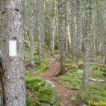
Footpaths
Footpaths First writing is done by feet. When we walk, we make marks and we make meaning. A path is deep writing. It is a material surface that over time becomes worn and accommodating, but it is also indexical, pointing out a direction–actually two. In addition, paths are communal: formed and maintained by community while at […]
Hiking Time
Hiking Time Portions of the Te Araroa require hitching a ride on a boat. Opua to Waikare is an extra 25km if you don’t go by water. I opted for the boat not just out of laziness, but also because I wanted a different view– oyster beds, derelict boats, grand waterfront houses, and old shanties–but […]

Solitude
Solitude On the second day out from Cape Reinga, the trail led up from Twilight Beach over Scott Point and down to Ninety Mile Beach, named not because it is ninety miles long (more like eighty couple kilometers), but because Captain Cook, on his circumnavigation of the island named it the Ninety Mile Desert. Hiking […]
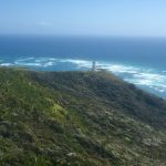
Commencement
Commencement Cape Reinga, the northernmost point in New Zealand, is the Springer Mountain of the Te Araroa trail, the place of commencement. There is no public transport there, so you have to rely on hitchhiking, book private transportation, or get a ride on one of the tour buses that take tourists to various sites (Kauri […]
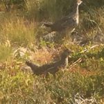
Animals
Animals Pacific Crest Trail, August 2015 One of the first things to strike you on the northernmost part of the PCT is a pervasive silence. The forests breathes, but the birds and squirrels generally don’t chatter (except in Canada; Canadian squirrels make a racket!). It’s like being in a pre-Internet library. Not to say there […]
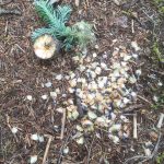
Foliage
Foliage (Pacific Crest Trail, August, 2015) Starting out, the plants are two–Douglas Fir and blueberries. The ancient trees loom. They have dominion. But the blueberries proliferate, and they are flavor. Their bushes vary in size and color, as do the berries. The ones with red leaves growing close to the ground seem always to give […]
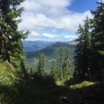
Surface
Surface The Pacific Crest Trail in the Northern Cascades of Washington has a surface that, when not scree, is soft, springy soil composed of fresh and decaying needles, cones, and wood from the giant trees that dominate this world. Dig down a few inches and you will find grey sand– fine particles of granite, […]