Walking Home

reveries of an amateur long-distance hiker

Day 75

November 15th, 2015

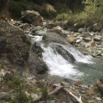
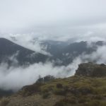
Nov 14 day 75 Mid Wairoa Hut to Porters Creek Hut 7:15-5:15 24 km

image

One of my “pointless” essays is about “surfaces,” something that insistently called my attention all day. It started with a very sharp up, which then dropped me back down on the banks of the left branch of the Wairoa River. Just like the Pelorus, the Wairoa is that indescribable pellucid blue/green, a color I really have not seen before. The whole morning stretch was waterfall after waterfall. I was hiking upstream, and they got more dramatic the further up I got. The walking was tough though, very narrow rock ledges over sheer drops which required a lot of concentration. I could see signs where people had slipped (not bodies or bones, just long skid marks). There were also about eight stream crossings. The water was not deep enough to be of concern, but it was very cold early in the morning, and of course I then had to spend the rest of the day hiking with wet feet. Along with the stream hiking and narrow rock ledges, there were excursions into the dense forest along the river banks. There the roots of old trees were densely matted with dirt and plants in the interstices, but in many places the actual subsoil had washed out, so I was walking on a thin layer of roots and dirt suspended over a void. Often my trekking poles would go through, fortunately not my feet. It did make an oddly hollow sound and was a springy way to walk. There was a hut upriver about ten kilometers, and there the trail left to river to ascend Mount Ellis and some of the surrounding peaks (around 1600 meters). Through that stretch which was above tree-line, I felt as though I was in a contractors supply yard. I’d hike over rocks the size of basketballs, then baseball size, then increasingly finer gravel. In the afternoon, the geology of the area changed as I moved into the “red hills” which are composed of mineral rich igneous rocks with a lot of iron (hence the red). They weather sharply and the large rocks are very difficult to walk over–definitely shoe killers. The afternoon continued with the strange surfaces– more red rocks on ridges that made me expect to see the Mars Rover come cruising by. The trail kept going up and over ridges, then back down to rivers, making it difficult to get a sense of where it all was going, though the trail proper was incredibly well-marked by tall orange snow poles. Often there were long scree traverses, and toward the end of the day, instead of gravel sized scree, it was more like sand which on steep banks moved under my feet. At several places the traverse would be within ten years of a cliff drop-off. One slip, and there would be no way to stop, which made those points even more nerve wracking than the morning’s narrow cliffs. Needless to say, I was happy when I saw in the distance of the bright orange painted Porters Creek Hut. Another very long strenuous day, early to bed in hopes that I make it to town tomorrow. I hear that the Nelson Lakes Motel has a big barbecue on Sundays, all the more reason to be sure I get across those rivers and into St. Arnaud.

Day 74

November 15th, 2015

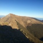
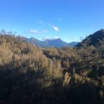
Nov 13 day 74 Slaty Hut to Mid Wairoa Hut 28 km 6:45-5:30

image

Not to be hyperbolic, but without doubt this morning’s hike was the most beautiful of the entire trip. The sun was bright, air frozen crystal with little wind. Darek and I left early, the gravel crunching beneath our feet and sprouting long thin ice crystals. It is easy to see how the soil, rocks and mountainsides heave if you just look down at pebbles suspended inches above the ground by tiny ice-crystal trees. We were both a little apprehensive. The two peaks of Mount Rintoul are famous for their difficulty. Lots of loose scree, some very narrow ledge passages near sheer drops. It is both technically and physically rigorous. It was very cold but I kept taking off my gloves to take pictures, though they are weak versions of what we are in, damn, it was just amazing. The early morning included a scramble up Old Man (which by the way is how I feel at the end of today), then a few km through scrub forest and a sharp climb, at first still in tree cover, then above tree line. By mid-morning we had summited Little Rintoul, but then the real work started, rounding the summit and dropping down a river of scree to work our way around a fractured ridge and then up to Rintoul proper (over 1700 meters). The rocks slid beneath our feet through the whole process, with Darek taking quite a tumble at one point. By late morning we were at the top and could see snow covered peaks in the distance at most points of the compass. It’s not fair to the rest of the day’s track to be compared to this morning. It was a lot more up and down, the down on very loose and skittery rocks. We got down to Rintoul hut, Darek wanted to rest there for a few hours, then go on to the next hut. I was hoping to get a little further, so I pushed on hard, making it to Mid Wairoa Hut after nearly 11 hours of very hard hiking. Took care of cooking and unpacking immediately. I’m writing this over a cup of tea, and my eyes will be closed on this day long before this day closes.

Day 73

November 15th, 2015

Nov 12 day 73 Slaty Hut 0 km (a snow day)

image image

So last night it started raining a bit, something the weather report had warned about. I was not too concerned because it was supposed to finish before morning, and the trails here are very dry, so a little rain would not have any impact. In the middle of the night, I went outside to piss and at first could not understand the strange light all around me: snow. It was still flurrying in the morning wth high winds. All the books say do not get near Mount Rintoul in bad weather as the passage includes a lot of rock scrambling and some very narrow ledges over steep drops. The Richmond Range might be the Tararuas all over again. I still have some serious alpine hiking ahead, much of it slow slog over scree; it will take a lot of time to get across to St. Arnaud. Spent early morning making a fire in the wood stove, reading Heidegger, and drinking coffee. In the back of my mind remains the possibility of running out of food or electricity. I have a back-up battery to keep navigation instruments going, but will have to suspend reading and writing if it starts to run down. Everything I do now requires careful deliberation. Mid-morning Darek arrived from the Starveall hut. It was still snowing a little and the wind was high, but the walk from Starveall is not technically or physically rigorous. The next hut –Old Man hut–is pretty far off the trail, and immediately after that is Little Mt Rintoul, so going on today did not make sense for him. The weather is supposed to be good the next two days, so we both decided to stay (plenty of firewood, comfortable hut) and take on the alpine scree tomorrow. Fortunately the wind dropped and the sun came out in the afternoon, melting much of the snow, so I hope tomorrow’s hike will be smooth. Got some pretty serious cabin fever by late afternoon though. Wrote a while about Thoreau, guess I need to get into his cabin frame of mind. By the end of the day, I was thinking hard about isolation, something quite different from solitude as the former brings with it a barrier and inability to communicate or engage. We may seek solitude for contemplation, relaxation, thoughtfulness, but isolation forces such modes upon us. There is a perverse pleasure in isolation, a helplessness that excuses a lack of sociality or even simple communication. It is pleasure and anxiety put together, a form of being that is both difficult and liberating.

Day 72

November 15th, 2015

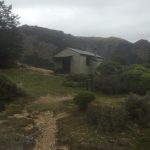
Nov 11 day 72 Rocks Hut to Slaty Hut 25 km 6:45-4:00

image

All business today, not that it wasn’t a pretty walk. It was, with varied surface– a little mud, a lot of stream crossings, some high elevation scree to slip and slide on, and even some rock climbing. Mostly it was a lot of elevation change–up, for the valley floor to about 1400 meters in four kilometers. Exhausting. At some point a few years ago, a storm or tornado came through this area and knocked down innumerable large old trees. The have done a good job clearing and/or rerouting the trail, but it is still eerie to walk through all these upturned giants. After my experience in the Tararua range, I was curious about how hiking time and distance will play out in the next week or so, as much will be above tree line and very exposed. It rained a little today but is supposed to be clear tomorrow. I am hoping I don’t get stranded in a hut because of weather, but also hope I will be able to make reasonable hiking distance over the peaks. Today was hard, but I got my 25 km. Tomorrow is the Rintoul peak, supposed to be the hardest part of this section. Here’s hoping for sun and no wind. Early to bed, really tired.

Day 71

November 15th, 2015

Nov 10 day 71 Pelorus River Bridge to Rocks Hut 32 km 6:45-3:45

image

There is a hiking adage that says “take what the trail gives you,” which generally means take advantage of easy parts of the day to make some time. Often after a long climb, a trail will suddenly flatten out and present a smooth path. It’s then that I try to stretch out my stride, loosen muscles and make some distance. Facing a very long stretch — many days — in some rugged mountains, I realized I should take what the trail gave that first day, which was a 13 km road walk before winding up the edge of the Pelorus River and finally climbing up about 900 meters to end at Rocks Hut. The Pelorus is an amazing blue/green river flowing over white gravel with deep pools. It must be amazing to hike and swim in the summer. The weather continues to hold beautiful, and the trails are dry, such a complete difference from the North Island. The hiking was hard but not frustrating, and I crossed the river and several streams via high swinging bridges. A man from Poland named Darek was at the hut, so we spent the evening in conversation.

Day 70

November 15th, 2015

Nov 9 day 70 Havelock to Pelorus River Bridge Campground 21 km 9:30-1:30

image

A leisure day before a long week up in mountains. Spent early part of morning packing, organizing gear/food, and watching the NFL Red Zone tv show. First American football I’ve been to see for any length of time. Packing out today with heaviest load yet, carrying seven days food. Had to use extra stuff bag to fit it all and can’t close the top of my pack. Hope the rain holds off until after I eat some of it. Before leaving, I had a “world famous” bacon butty at the Havelock bakery/cafe, then headed down the road. Was a flat, road hike, mostly on a logging track, so it was pretty dusty and I had to get out of the way of the big logging trucks. Arrived at Pelorus River in time for lunch at the cafe. It’s a DoC campground but first-rate with high tech showers, laundry, kitchen, and of course the cafe. The only drawback is that it isn’t licensed, so no beer, sigh. Set my tent up by the river, the same one I’ve been following all day today and will most of the day tomorrow. I had a quiet afternoon reading and writing on the deck by the camp kitchen, only drawbacks are all the sand fleas which really do draw a lot of blood, so I had to dig out the full strength DEET. Went back to the cafe for sorbet and tea– I’m so cultured– and then had to figure out how to heat a meat pie without an oven. I put some water in my Jetboil, put it on the stove burner and plunked the pie on top. The bottom of the pie got hot and soggy, the top stayed crisp and cold. Still, it was good. A young Swedish came by with their two children were cooking there too–he is an avid fly fisherman trying to interest his five year old son in the sport. Unfortunately there were no trout in this stretch of the river today, and the son was more interested in his soccer ball. That reminded me of my sons, who could entertain themselves for hours wi a soccer ball. Actually they still can, though the projectile of choice these days is more likely a frisbee. Two observations about the South Island– so far, no rain (four days of sun in a row is definitely a record) and a lot more bugs, particularly flies. Made me realize that it is not that there are a lot of them here, but that there were so few on the North Island. I’m not sure why, but I’m guessing colder weather and higher winds. It’s been much warmer this last week, as if Spring is finally here.

Day 69

November 8th, 2015

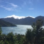
Nov 8 day 69 Portage Bay to Havelock 36 km 7:30-4:00

image

Day started as one simple move– make good time to Havelock to position for a long isolated trek to St. Arnaud. The queen Charlotte really is like a sidewalk on this part– some beautiful views, but also a path to make time, which I did. I had met some mountain bikers at the hostel who eventually passed me on their way to Anakiwa. I had remembered being there 10 years ago, but it is very built up now. I hoped to get a late breakfast there, but no cafes have opened yet. I had lunch from my pack at a bench overlooking the sound, then headed down the road to get to Havelock (the green shell mussel capital of the world). The only glitch in a well-choreographed day happened when I went up a trail to cross a ridge leading straight into Havelock. I followed the new “link” trail, hoping it would take me where I needed to go, but of course, it dumped me out on a road at some distance from Havelock, effectively adding about 5 km to an already long day (probably hiked over 40 km today). When I finally arrived in town, spoiled hiker that I am, I opted for a room at the Havelock Motel where I could relax my sore hamstrings in a hot tub. After resupply at the Four Square, I went for dinner at the Green Mussel cafe, making a hard day a good one.

Day 68

November 8th, 2015

Nov 7 day 68 Furneaux Lodge to Portage Bay DeBretts Backpackers 34 km 8:00-4:00

image

There is something about the familiarity of this area that makes me both happy and nostalgic. I hiked the Queen Charlotte over ten years ago, and also parts of it a few years back with my colleague Greg. It is New Zealand tramping at its most civilized– well-maintained trail, many possible accommodations, and food available at most points during the day. Had a late start (at least for a possible 35 km day) because the bed was so comfortable and then I made coffee and sat out on the lawn watching the morning come in. Once again the weather was perfect and the morning tramp cool and pleasant. Mid-morning I arrived at Punga Cove, another place that made me smile, and had a late breakfast or an early lunch. It was there that I learned about the special pass you have to buy now to hike the Queen Charlotte (18$). It is the only New Zealand trail you have to pay to hike, the result of a couple of landowners who got together to deny access without recompense. Background is important here: there are thousands of kilometers of trails in New Zealand and many if not most cross private land at some points. Those passages are always well posted and trampers have to exercise caution around livestock, close gates, show respect, but landowners allow the access and put up with the nuisance because it is all part of what makes New Zealand the country that it is. There are fees to pay for staying in hut and campsites, but never to hike except now on QCT, which is, because of the fee, no longer one of the NZ Great Walks, a designation that carries a lot of prestige and economic growth to the area. The people who run lodges and campgrounds are very disappointed. It turns out the landowners causing all this turmoil are American. Arrrggh! I didn’t let it spoil my day, though I gritted my teeth every time I saw a sign for the QCTLC, as they labeled everything in that section — benches, picnic tables, etc., as if that generosity makes up for their avarice and failure to understand the country they have chosen to live (or at least own land) in. From Cove to Portage bay was a long but not difficult walk. My feet were tired when I found a bed at DeBretts Hostel, a place full of cyclists for the weekend. Wandered down to the hotel for fish and chips and a pint. Satisfying day.

Day 67 South Island Odyssey Begins

November 8th, 2015

Nov 6 day 67 Wellington (via ferry) to Ship Cove to Furneaux Lodge 13 km 4:30-7:00

imageimage

The South Island Odyssey Begins
Caught the 9:30 InterIslander ferry to Picton. Absolutely crystal day, I could feel everyone’s enthusiasm for some warmth and sunshine. Crowded boat, but I found a seat on the back atrium sundeck. Good views without the jostling of the already drinking crowd, and I got to talk with one of the librarians from the National Library, where I hope my students will do some research in January. Arrived at Picton just in time to get a quick bite to eat and catch the mail boat, which after stops in nearly every cove on the sound, dropped me at Ships Cove, the beginning of the Queen Chatlotte Track and Te Araroa on the South Island. Hectors dolphins sported beside the boat as we made our way over. This is a trip I have taken three or four other times, and the peacefulness of the coves and bays always amazes (of course they are also subject to severe weather, a characteristic of the entire country). The Queen Charlotte is an “easy tramping” trail, perfectly graded, so I made the crossing to Furneaux Lodge in quick time, and was happy to feel very strong hiking throughout. Ever since the Tararua’s I have felt tired and lethargic walking, almost weak, so it really felt good to be feeling good. Hoping to get a running start at the South Island, so it was a good sign. I have always wanted to stay at Furneaux. Eaten here on the way through a number of times, but haven’t spent night. I got a great bunk room looking out over the bay, really comfortable, wish I could linger longer. Planning a weekend trip in January which will definitely involve lingering.