Walking Home

reveries of an amateur long-distance hiker

Walking to Cape Wrath, Day 3 May 13, 2022

May 14th, 2022

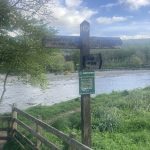
Walking to Cape Wrath, Day 3 May 13, 2022

Much as I like to celebrate life on the open road, some days fall into the category “no fun.” I’ve already heard the term “Scottish weather” countless times, but today even the most grizzled Scot owned it was some wind. Guess I should have been suspicious when the weather just posted an image ?, particularly since today’s hike was billed as a beautiful trek along the ridge line.

Of course it was not all brutality, the morning out of Melrose included more beautiful wandering along the River Tweed. After a half-Scottish breakfast (I declined the tomatoes and beans, and they didn’t offer blood pudding), I wandered down Main Street, picking up some oat cakes and fruit as today’s route crosses no towns. I soon passed the rugby field— clearly the favorite sport in this region—heading toward the river with its fishermen and dog walkers. After a bit, climbing up the river bank brought Skirmish Hill, a place where in 1526 various Scottish nobles (including James V) decided to kill each other. At one point later I had a wonderful sense of deja vu as the path opened out onto the Tweedbank train station, the spot where, on my first day, I caught the bus to Kelso on the way to Kirk Yetholm. Then there was a lot of walking through sheep fields and the edges of a large town (Galashiels) until finally breaking out into the true countryside. There were pastured hills and woods with the forest floor carpeted with Scots bluebells. Near midday, I began the long climb out of the valley to a high hill topped by the Three Brethren— three large stone cairns next to a trig point looming over a broad landscape.

That’s when the unfun began. Initially it was just like much of the ridge line I’ve been in so far— far below stonewalled sheep and cattle fields and close cropped pasture, and closer by, heather about to bloom. But on the distant hills were forests, not a Sherwood Forest full of oaks and merry men, but instead a plantation. I was crossing land owned by the Duke of Buccleuch, apparently one of the largest landholders in all of the UK. While much of the land was open, vast tracts were planted up in nice clean rows of pine—one of those monocultural pine plantations derided by environmentalists. Of course Scottish tree plantations date back at least to the Earl of Atholl whose land on the slopes of the Cairngorms became test ground for both mono and poly arboriculture. But here we are talking straight-up industrial tree farming.

And the wind the weather people predicted hit with full fury. I had passed some hikers who were heading east (the wind at their backs)— they looked on me with pity, knowing what an afternoon I was in for. I’ve been in worse (that would have been an attempt at the Tongariro Crossing in 2015: https://walkinghome.lmc.gatech.edu/te-araroa-walking-south-with-the-spring/day-43/), but today did involve some staggering wind. Thankfully all my equipment (including those titanium knees) performed. It was straight up exposed ridge hiking in the teeth of gale force wind, the only respite was in the lee of one of the Duke of Buccleuch’s tree crops (one bright spot was a stretch on an old drove road, making me glad I had read A.R.B Haldane’s Drove Roads of Scotland).

On entering the forests, it became clear what I was experiencing was the merest trifle. Massive old trees, whole swaths of timber were down, almost as if some giant child had brushed their hand across the landscape, flattening arbitrarily tree after tree. I was inspecting first-hand the handiwork of Storm Arwen, an extra-tropical cyclone that, between 25–27 November 2021, devastated the woods across the UK, with nearly 100 mph winds hammering this corner of the world. The only comparable experience I have was the derecho that smashed into the mountains of Virginia in 2012. There the hail was as large as I’ve ever seen and thousands of old growth was leveled (https://roanoke.com/archive/volunteers-clearing-the-appalachian-trail-of-blown-down-trees/article_15302054-c1b2-59fe-9bd7-fd977ac1bb76.html).


Fortunately by mid-afternoon I was descending to Traquair (the official endpoint of today’s trek) and in a light rain I made my way to the Tweedside Caravan Park in Innerleithen where, after waiting in a pub for the rain to abate, I pitched my tent and then had an amazing meal (duck confit) at the Traquair Arms (a place well worth a visit). Very happy tomorrow will be a short day.

T. Hugh Crawford

Walking to Cape Wrath, Day 2 May 12, 2022

May 13th, 2022

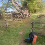
Walking to Cape Wrath, Day 2 May 12, 2022

When hiking the Appalachian trail, I tended to obsess over wet feet (an unfortunate obsession to have, particularly in Vermont). The trail is so brutal, it beats your feet to death, so factors like wet feet can exacerbate an already fragile constitution. On New Zealand’s Te Araroa, I quickly learned that wet feet were a requirement. On the North Island, many sections of the great path are actually routed down the middle of a stream. I remember on the South Island crossing Waiau Pass, running down a melting glacier to find a place to tent in a wild woods. There I built a fire (something I rarely do) and dutifully dried my shoes and socks. The next morning, on hiking out all of 20 yards, I had to ford a waist deep icy stream. So much for dry feet. (https://walkinghome.lmc.gatech.edu/te-araroa-walking-south-with-the-spring/day-78/).


While not nearly as dramatic as running down a glacier from the highest point on the Te Araroa, I did find myself reliving the old wet-feet anxiety when, on heading out from the Lillardsedge campground after a fairly heavy midnight rain, I had to find a way to cross a field to regain the trail. A tree line which was probably the remnants of an old hedgerow provided a guide and a path, but of course it was completely overgrown with coarse grass and within seconds my feet were sloshing in my shoes. My Appalachian trail spirit screamed “turn around” in one ear, and my Te Araroa sprit just said “sweet as.”

I crossed the field without much incident beyond moisture and found a first-rate trail winding through a lane of old beech (with the highway humming in the background). It turned quickly into a pleasant wander through fields, hedgerows, small towns with beautiful old chapels, and of course Welly-shod dog walkers— just the experience I expected. There were parts of that woods walk that reminded me of the eastern mountains of the US, except the dominant trees were beech rather than oak or poplar. You have to love a good beech forest.

The afternoon was spent following the River Tweed, with swans, fly fishermen, and carpets of wildflowers (dominated by Ramsons). Late afternoon took me through the Eildons, three peaks made famous in Scott’s “Lay of the Last Minstral.” The path went up through the saddle, so I was tempted to summit, but as per the last few days, mid-afternoon brings mist and rain, so I opted for the descent into Melrose, a beautiful town with a ruined Abbey.

I checked into the Station Hotel, late lunched on a haggis burger, visited the abbey (which is where Robert the Bruce’s heart is buried),  wandered the town, finally boarding The Ship—another classic pub, this time filled with football fans waiting for the game to commence. Still adjusting to time, weather, and pure physical exhaustion, I found myself returning to the Station Hotel early for some luxurious sleep on a real bed (no tent and thin sleeping pad for me): a day well spent.


T. Hugh Crawford

Walking to Cape Wrath Day 1, May 11, 2022

May 12th, 2022

Walking to Cape Wrath day 1, May 11, 2022

In 2014 I walked the Pennine Way, finishing at Kirk Yetholm just across the Scottish border. What I remembered most about that hike was wandering the Yorkshire Dales and the crazy weather up on the ridges, but the last part was in the Cheviots, a different topography and sensibility. Obviously settled by farmers for millennia, the granite mountains are humped, rounded hills covered with close-cropped grass— the work of sheep over centuries. That world doesn’t change at the border, so today was spent climbing cheviot humps, covered with grass and sheep— it’s lambing season— and rimmed with gorse (loved by Eeyore, enjoyed at a distance by walkers, but a brutally difficult plant to manage).

Technically I started the Scottish National trail yesterday at Kirk Yetholm as I left the village to stay in Town Yetholm (1/4 mile) at a campground. I set up my new ZPacks duplex tent— my original Soloplex lasted through the Te Araroa, Nepal, the Camino, TransSwiss, Laugavegur, Tasmania, and the Benton Mackaye before finally giving up the ghost. I’m loving the replacement. The wind was brutal even though I was pitched in the lee of the shower house, but I slept like the dead, causing a late start.

That first night in Town Yetholm I stopped at The Plough—the town pub and a classic rural establishment. Late afternoon a crowd of locals had gathered, picking up on the stories they probably had been telling the day before— lots of good natured ribbing which they soon directed toward me. My ear not yet attuned to the accent, I missed half the comments, but from their demeanor, none of the insults were Ill-intended. And of course there was the obligatory large dog sleeping in front of the fire.

I was reminded how close the community is in rural pubs—composed of locals and the many walkers who fill the paths all over the country. They returned from their walks and burst through the pub door. You can see the wind still in their faces. It takes a moment for the outdoors to leave them, then they set their inside faces, warm from the day’s walk and the close air of the pub. I half listened while eating bangers and mash, soon dozing off, so rousting myself like a dog from the fire, I made my way back to the campsite huddled against a strong wind.

Before setting off in the morning, I stopped at the local post office/convenience store where I got McVitties Digestif crackers (fundamental hiking food) and some cheese and crackers. While sipping my coffee I was greeted by a stream of farmers stopping by to pick up a newspaper before returning to the fields. Even the gruffest were quick with a greeting and smile. Just before I left, the woman running the store stopped by the front door. We were looking out over the Cheviots with their gorse lit up by the morning sun. She asked where I was going, smiling approvingly when I said I was heading up to the hills. We talked the weather and she explained how much of this area have their own micro-climates—that in the winter one village will get snow and the next won’t. Then she looked up to the hills declaring it a wonderful place to live— something for her that was simple fact.

The morning’s walk was a long slow climb out of the valley, occasionally crossing the river and fields of sheep—it’s lambing season, so sometimes a wide berth was necessary. Late morning the trail worked up to the top of the ridge with the wind continuing to howl.  Most walkers on this section are doing the St Cuthbert, and they start from the west to hike to the sea. I passed many of them, all with the wind at their backs, while I plowed ahead face first. Sometime later in the morning I crossed Wideopen Hill. Measuring 1207’, it is the highest peak on the St. Cuthbert Way, which just is a reminder this is part of the Lowlands. By midday I was in Morebattle eating a big lunch, and then set off for a pretty difficult afternoon— first some nice forest walking, mostly in beech and birch woods. There are no accommodations at the standard endpoint (and unlike most distance walkers here, I’m not using a baggage and van service), so I needed to push forward, making a long day even longer, finally landing at the Lillardsedge campground around 6:30– too long for a first day trekking. Still, a nice place and I slept once again like the dead

T. Hugh Crawford

Career

June 20th, 2021

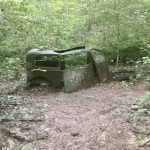
Career

The northern parts of Benton Mackaye Trail prior to entering the Great Smoky Mountain National Park generally consist of thin, overgrown paths—steep, rutted, rooted, wet, rocky, and usually devoid of other humans (plenty of nonhumans though). Solitude in those circumstances is not contemplative. Instead each step must be taken with care and precision, a mentally and physically taxing process. All trekking involves paying close attention to surface as that, often more than distance or altitude gain and loss, determines the mood of the day. On entering the Smokies, that surface mood shifts. It is a region long inhabited by the Cherokee people and later by Appalachian settlers. Their occupation is most evident by the trails and roads that remain today as current ways or ghostly presence. Doubtless, the road with the most powerful resonance in this part of the world is the Trail of Tears. The settlers who displaced the Cherokee built on their local paths. Today walkers encounter remnants of game trails, washed out logging roads, as well as other roads more carefully built (some still maintained by the Forest Service for access). Ralph Waldo Emerson, in the “Language” chapter of Nature notes, “Every word which is used to express a moral or intellectual fact, if traced to its root, is found to be borrowed from some material appearance.” I’ve long found it curious that the etymology of “career” is in part a headlong race, but also refers to a well-built track or road. Traversing well-laid and some not-so-well-laid roads on this part of the Great Smoky Mountains National Park, I decided to think with Emerson a bit, trying to understand career as “material appearance.”

Rummaging around my memories, the only place I could recall the word career used in its earlier sense was The Wind in the Willows where, as I remember, Mr. Toad’s wild ride involved a car careering at high speed (I could be mistaken, but if Grahame didn’t use the word, he should have). It is hard to imagine how the contemporary sense of having a career would relate to a headlong dash like Mr. Toad’s recklessness, but the idea of a well-laid road resonates with my sense of career. Careering on the Lakeshore Trail in the Smokies, I encountered, of all things, cars—slowly rusting hulks of 1920’s vehicles, one with an old tree growing up through it. Not the sort of sight you expect in the so-called empty American wilderness, but also not surprising given the path I had been following was once a fairly well-made road. Heading north not far past the cars other evidence of Appalachian settlers emerges— old sheet metal, beams, axles, the remains of an old mill race and stone mill, and then the Calhoun House, the last standing structure of the Proctor community. In the late 19th century Proctor was an agrarian village. In the first decade of the 20th, a railroad was pushed there, and Proctor became a lumber boomtown, swelling to over 1000 inhabitants until the timber was exhausted. During World War II, the Alcoa aluminum plant needed smelting power, so the Fontana Dam was built, with the lake submerging parts of the town. A promised road to Proctor was never finished, though the “tunnel to nowhere” some miles to the east is now a tourist destination. The remaining town dwindled and then disappeared, with most structures disappearing into the regenerating forest. I would guess that disappearance was also hastened by the National Park service— a whole nother story of displacement.


Emerson opens
Nature with “Our age is retrospective.” Without doubt, the roads around Proctor invite retrospection, thinking about lost human communities—violently displaced Native American people and the later scattering of the settlers who followed. Now it’s only trekkers who transiently occupy that space.

Standing on the bridge over Hazel Creek, it is hard to imagine a town of any size occupying this space, let alone an industrial sawmill or fields large enough to support food production, but at one time the narrow dirt roads and those abandoned cars enabled the transportation of goods— corn or, for greater ease of transport, corn liquor. Present day stock car racing has its origins in these hills, with cars modified for speed and strengthened to carry gallons of moonshine to the flatlands below.  (I grew up with a 50 gallon copper still in my backyard). The railroad was built to haul out the timber, but in those years it likely also carried a commodity nearly as valuable as shine— chestnuts. Another important inhabitant now gone from this area—the American Chestnut—was lost in the early 20th century to the blight. Once the dominant tree species of the southern Appalachians, the chestnut was fundamental to the life of most inhabitants. For humans, the leaves provided medicine, the wood was nearly perfect—plentiful, strong, rot resistant, easy to work (many of those traditional log cabins in old pictures are chestnut). But most important were the nuts. Plentiful in mast years, chestnuts were a key source of nutrition for humans, were used as forage for hogs (another human food source), and, with the coming of the small gauge railroads up into the coves and the opening of markets in the US northeast, a source of income. A generally unrecognized cause of community loss and present-day Appalachian impoverishment is the environmental devastation brought on by the chestnut blight. The loss of the trains parallel the loss of forest, the chestnut, and the life of many small communities.

Thinking about the idea of one’s career as either headlong dash (Mr. Toad) or a retrospective pondering of lost patterns of living (Proctor) does not seem particularly helpful. Generally people’s careers are not sprints, but they do open out onto a future, not to look back to a distant past. There are only two modern careers I’m qualified (somewhat) to use as examples: medicine and academia. My father was a small-town surgeon and ER physician, and later a public health director. In those years I observed him (including observing operations gowned-up at the OR table) and read the many histories of medicine in our home library. Later, for my dissertation I studied the history of medical education in America. That led me to the other career I have some understanding of—though it is a world I find increasingly strange—professing the humanities in a university. (N.B. I entered the academy in the 1980s when it was generally possible to find a university tenure track job. The neoliberal takeover of the American university system has made that path a chimera today, radically transforming any notion of career).

A career regarded as a well-laid road is at best banal, but perhaps thinking about or with the material experience of roads, paths, and trails could bring some insight. Standing on the Hazel Creek bridge looking across at what is now a riot of trees and undergrowth, then turning to walk for a short stretch on the still level abandoned railroad line, doesn’t so much produce nostalgia (deforestation is hardly something to sentimentalize), as it frames the moment in a dense and complex historical context. Modern roads—e.g. Interstates—appear to erase their history through sheer speed (though attention to what is abandoned by such a-historicism can be compelling). Maybe that is a way into the notion career. As those familiar with the current state of the university in America know well, we are currently being transformed into a “knowledge economy,” which defines knowledge as that which can be measured by standardized metrics, emphasizes rapid production and context-free digital dissemination. In addition, the very idea an academic career has been aggressively undermined, shifting much of the professoriate to precarious, adjunct labor where the time necessary to pursue knowledge is compressed or eliminated. However, harking back to some illusory “good old days,” in academic life is a fool’s errand. The professoriate I entered in the 1980s was overwhelmingly white, male, and academically elitist. A naive celebration of that time as a point of pure intellectual plenitude would be profoundly misguided. Nevertheless, as the road(s) to Proctor teach, it is still important to pause at ghostly presences and listen to what they might tell. That site of rapacious deforestation was also a place of human community—one that maintains a fragile continuity as the descendants of Proctor continue to visit the cemeteries annually to connect with their ancestors and with the still-living descendants of those families. In our corporate universities, the knowledge economy commodifies the parts of academic life that submit to metrics and generally ignores those which cannot. Put bluntly, wisdom—the traditional (idealistic) goal of the humanities—no longer has a place or is at best a ghost.

Perhaps a way to contextualize this trend in academia is as a transition from the idea of career traditionally construed—a road well-laid and followed by careful study and understanding over time—to one defined by readily signaled and celebrated waypoints. The Appalachian Trail is often called “the green tunnel” because it (like the Benton Mackaye) rarely offers those celebrated panoramic views. Days are spent in a long trudge, seeing feet, rocks, toads, snakes, and flowers, even as those same hikers tend to represent their walk with selfies on cliffs and peaks. Today’s humanistic academic careers are forms of branding defined by similar selfie moments. Academic brand development uses every tool in the social media arsenal to not just commodify knowledge, but also the supposed bearer of that knowledge.

This essay springs from my hiking the Benton Mackaye Trail, a path starting at Springer Mountain, Georgia (the same point of commencement as the Appalachian Trail which, by the way, was originally conceptualized by Benton Mackaye). It winds northwest through the Georgia Appalachians, crosses into Tennessee, follows the Tennessee/North Carolina border for a long stretch, ending by crossing the Great Smoky Mountain National Park, climbing Mt. Sterling and descending to the end point in a parking lot—all told about 286 miles of difficult trekking in nearly complete isolation. A bad foot forced me off just before the Mt. Sterling climb. In the career-as-brand world that would be a complete failure as I cannot take the selfie and check off the box for reaching the end point. I can’t wave trekking poles, posing for a social media moment, and then tweet about it (incidentally and ironically, cell service is rare on the trail, so social mediation is always delayed). But, to state the obvious, knowledge and understanding comes in the middle of that long green-tunnel trek, what Gilles Deleuze calls the milieu, and that is precisely what is most often left out of brand development. Proctor is learned by a long road(ish) walk in, through, and back out, not through a Google search or captured by a perfect tweet. So what emerges by thinking career via Emerson are these two versions: one of narrowly defined goals, a series of discrete way-points easily plotted on a roadmap, multiplying products (content) rapidly across media platforms, and constructing a recognizable brand (scholarship as hype-house). The other is career as becoming (a Deleuzian Nomadology), the result of engagement with an unfolding process. The latter recalls the Scottish writer Nan Shepherd, whose Living Mountain I discussed in a previous Pointless Essay. On setting out to walk a Cairngorms path, she says, “Yet often the mountain gives itself most completely when I have no destination, when I reach nowhere in particular, but have gone out merely to be with the mountain as one visits a friend with no intention but to be with him.” I suspect a brand-oriented academic would hesitate putting that in an annual report.

The dark side of all this is a definition of academic productivity borrowed from the corporate world that simply does not fit the job of nurturing wisdom. Not just confined to the humanities in the university, these tick-box, rapid production pressures are felt across most disciplines including the sciences, a point made clear in Isabelle Stengers’s Another Science is Possible. In what I recall as a recent interview, Donna Haraway voices her preference for the term “engender” over “reproduction” or “production.” She is making a different set of observations than I am, so her reasoning follows a different path, but it is a helpful distinction. Put simply, to live and work, to have a career, in a (re)productionist model requires the fabrication of products— closed, packaged things, a list of intellectual entities on a form. Engendering is a practice of bringing into being possibilities latent in the context. A self-reflective example: what you are reading just now is in my walkinghome blog under the category “Pointless Essays.” To me, the title is a redundancy. While most young scholars in freshman composition are harangued about the need for their essays to have a point, the very notion of an essay is actually its pointlessness. An essay is an attempt, a trying out, weighing (assaying) possibilities, exploring a set of ideas or concepts. An essay does not measure out in already established metrics some narrowly definable idea; instead “the mountain gives itself most completely when I have no destination.” To essay, in its purest form, is to explore, initially with a certain aimless tentativeness, to see what can perhaps be engendered. My initial walk along the Lakeshore Trail was not simply to tick off the 12 miles from Fontana Shelter to Proctor Fields campsite. Instead, the path, the different surfaces, the stray artifacts, but also the temperature, humidity, the angle of light, bugs, snakes, flowers engendered a form of thinking on careers.

Obviously there are plenty of activities in any career that can be captured by metrics, and, at least the way I was brought up, the very notion of having a career means making a positive contribution to society in whatever way one is capable. What the road/career connection helps uncover is that travel— moving through the world on historically constituted paths—will always include some metrics: beginnings, waypoints, measured distances, ends. But no thinking person sees those marks as constituting a career. They leave out everything in the middle which of course is where thinking is engendered.  As readers can easily infer, I’ve never celebrated digital media as a form of liberation, but I’ve found blogging an interesting way to resist the corporatization of knowledge. The conceit of the Pointless Essays section is that the general idea and/or mood of each resulted from material encounters on the trail, chewed over during that day’s walk. This particular essay was engendered June 16, the day after crossing Proctor Field, as I walked from Chambers Creek to Pole Road Campsite, 22.5 miles in the Smokies (also a day I had a disturbingly close encounter with an exceptionally large timber rattler which perhaps will become another essay). My audience, as best as I can infer, is made up of a few colleagues who read the same philosophers. Thoreau, Emerson, Nan Shepherd, Gilles Deleuze, Isabelle Stengers, William James tend to appear often since my questions are not drawn from reading but instead are posed by my sometimes vague recollection of their work while walking. By far the vast majority of my readers are other trekkers scouring the internet for accounts of different trails (see About Walking Home for a list of trails walked). And then there are some shadow web sites selling essays to undergraduates on nature writing who have appropriated some of mine (end of semester times usually show an odd spike in essays mentioning Thoreau).

What I find compelling about blogging is as an opportunity to treat the essay form as an experiment outside the academy. It engenders serious thinking without submitting it to banal metrics. As a form of intellectual work, it brings me no annual performance review credit. Just like the actual walking, both are practices very much on the margins of productivity or commodification. Sure, some people commodify trekking, creating their own brand and gaining access to equipment and sponsorship. In similar fashion, others find ways to commodify blogs. But neither approach is necessary, and when avoided, both the walking and the thinking take on a different tone, a tone I value. Their ends are not ends, but instead are an ongoing opening out onto novel and seemingly unending possibility. I find that a better sense of what a career should be.

T. Hugh Crawford

Walking to the Smoky Mountains, Day 20

June 17th, 2021

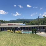
Walking to the Smoky Mountains, Day 20, June 17

Pole Road Campsite (55)  to Bryson City

The day opened in reluctance. I knew I had a 13 mile walk out to get to the road to hitch to Cherokee NC, so it wasn’t a simple stroll, though it was the end of a very long trek (250+ miles in these mountains is no joke). I geared up for the last time, following the rituals of the summer—those that sustain hiking and peace of mind. I had camped in a place where three different sites were closely connected, so soon after setting out, I was passing a site where three men were just about to start their trek out. Ryan, Jake, and Steve— three men finishing a three day fishing, hiking, camping trip— were on their way to the Deep Creek parking lot to head back home to Columbus Ohio (except Jake who was heading back to the main-line near Philly). They happily agreed to drop me at Bryson City on their way to Asheville, so, for the first time in many years, I fell into a walk with three other trekkers, alternately talking and walking in a gregarious and pleasant way— each was a really interesting person to walk with, so the miles melted away and soon, after seeing a number of waterfalls and watching the kids tube down the river,   they dropped me at the Relax Inn in Bryson City. The perfect spot to end this long Benton Mackaye Trek.

T. Hugh Crawford


Walking to the Smoky Mountains, Day 19

June 17th, 2021

Walking to the Smoky Mountains, Day 19, June 16

Chambers Creek (#98) — Pole Road Campsite (55)  22.5  miles

Right up to the end, a perfect hiking day. I remember moment in Earl Shaffer’s Walking with Spring when he describes how he hit a point where he ate twice what he had been eating. Long distance hiking burns huge calories so there is a point a few weeks into a trek where most of your body fat is burned off, and you have to increase consumption (though you can never keep up as long as you trek hard). I doubled my food last night and woke early (5:30) ready to go. I knew if I were to get in position to finish Saturday, I had to make up miles that my Smoky Mountain permit didn’t support (all part of a not particularly intuitive website inflicted on my schedule).  So my goal was a good 4 miles past my scheduled campsite, and more if possible.

Another experiment was coffee. I had packed some Starbucks instant just in case I wanted to fire up the jetboil stove in the morning before starting. That impulse never materialized (in part because I didn’t have any of that sweetened condensed milk in a toothpaste tube that they sell in New Zealand— a backpacking item worth its weight in its weight). So I dumped some packets in my nalgene for the early morning walk (I did feel a certain spring in my step.

As I said, a nearly perfect hiking day. The Smokies are in some places, incredibly isolated and untouched, but this area shows signs of long habitation, with most paths following what were some decades ago, primary roads to communities, so the trail was usually well-graded and a fast walk (necessary as I walked almost 23 miles). After miles of horse prints and piles of horse shit, I did finally meet two men astride soem amazing animals, so glad to see people following these traditional paths on the critters that made them.


The flowers were also getting dominant. Every shade (and of course the occasional “almost” ripe blackberry regularly appeared, as did, of all things, a long stretch of Day Lilies (the orange kind) lining the path.  I remember wilderness paths in Virginia near West Virginia as a child where those lilies also appeared which I guess is why I’ve never thought of them as a home garden flower. And as always, there were many streams with opportunities to re-water.  Much of the day was on Nolan Creek, a favorite of fly fisherman, and well worth the trek. One thing that struck me when filling my nalgene was the odd bass-drum thump that plays on the stream by the water in sudden holes in the streams. A fascinating symphony.

I made it to Bald Creek camp— which was further than my itinerary—by 3:30 so I decided to push on to the next site which was 4+ miles. Definitely my longest day if the trip, and of course the smooth trail I’d been on all day turned to a narrow, rooty, steep climb. Undeterred as I still felt good I continued on until I ran up on a huge timber rattler. He was coiled across the trail and I didn’t  see him— just heard. First response was to leap away, which was on the downslope side of the trail. There I found myself laid out prone, but I could see the rattlers— at least 10 pairs—shaking insistently. I scrambled to get up, only to discover my backpack was caught under a downed tree, so I watched to see if the rattler moved while I unstrapped in order to move on. Fortunately he stayed coiled— he was much bigger around than my biceps (maybe closer to my calves for those of you who need anatomical metrics). I made my way past his rattling circuit, stopped for a moment to consider getting out my iPad for a picture, then realized the snake needed his dignity too, so I proceeded on to the Pole Road Campsite— another completely empty one, to settle in (after 22.5 miles) for a good nights sleep.

Unfortunately that was interrupted by inspection of my long-sore toe which had now blown up to full-fledged infection. There I had to make the decision to abandon the trek just a two-day walk from the end, but a merit badge is not worth compromising health. My last night on the trail (and the last night in my ZPacks soloplex tent— a tent I’ve pitched on every continent except Antarctica— is now to be retired. The fibers after all those pitchings are now stretched thin (moment of nostalgia)). An uneasy sleep after what had been a glorious day of trekking. At least it was an evening of lightening bugs, a bright moon, and flood of stars— all observed because of late evening micturation.

Walking to the Smoky Mountains, Day 18

June 17th, 2021

Walking to the Smoky Mountains, Day 18, June 15

Procter Fields (#86) — Chambers Creek (#98) 15 miles

The humidity dropped, so apart from some general malaise (just feel like I’m running out of gas), today’s walk was excellent. Relatively steady altitude with sweeping curves up into the coves, rock hopping a spring or stream, then long moderate climb to cross the next ridge. There were none of those points where a steep climb made me sweat through everything and have to put my (already in waterproof case) phone into a plastic bag to avoid sweat-short.

The first bit was on the old turn-of-the-century railroad bed. Rails and ties were taken up long ago, but the bed remains in good condition. Later in the day, I was consulting the Guthook navigation app about upcoming waypoints, and was puzzled that they were all at the same attitude. Later when I got to that part, the trail joined that old railroad bed for most of the afternoon. The Lake Fontana can be seen through the trees, just a few hundred feet below. Was thinking about what it must have been like riding the logging train out from Procter, then realized that the train stopped running before the lake was built, so that was not their experience even as it was mine. I remember reading that, before the chestnut blight wiped out most of the forests here, a National market for American chestnuts was developed by running narrow gauge trains up into the Appalachian coves. I wonder if that train was part of that commerce.

Trying to plan out the end of this trip, and the last days will be brutal— several 18 milers ahead and the ascent and descent will be steep and long. Will just have to see how things hold up— I can abandon over near Cherokee if necessary.

T. Hugh Crawford

Walking to the Smoky Mountains, Day 17

June 17th, 2021

Walking to the Smoky Mountains, Day 17, June 14

Fontana Shelter — Procter Fields (#86) 12 miles

The Smoky Mountain Park service requires permits and a specific itinerary. To finish by Saturday, I need to walk 15+ days, but filling out the form, I dropped five from first day, so my day was as pleasant and pressure-free as possible. Leaving from a shelter (that has a bathroom) is much quicker than striking a tent and digging a cat hole, so I was crossing Fontana Dam at 6:30. Beautiful morning. In the initial days across the Smokies, the Benton Mackaye follows the Lakeshore Trail, which, as you would imagine follows the northern shore of Lake Fontana, ducking down to some of the coves, and climbing up around the various micro-watersheds. As the people I met yesterday who had just walked this section told me, water is plentiful, so even though it was hot, there was no danger of dehydration. And I even stumbled on a patch of early-ripe blackberries.

The path is also designed for horses, which generally means a wider, smoother surface with climbs at a reasonable grade. (That is what makes  long miles on the Pacific Coast Track possible). Much of today’s walk was on old logging or transport roads, particularly as I approached Procter.  Though this area seems long-empty, around the turn of the 20th century, Procter was a logging boom-town with a population over 1000. Today, apart from the road, the most conspicuous evidence is one building—the Calhoun House, built in 1928 and maintained (somewhat) by the Forest Service. In the miles around Procter you can see the remnants of old cars (straight out of Bonnie and Clyde), an old stone mill, and a range of rusting metal debris. I will need to check to see if someone has written a history of this area. It has the poignancy of post-chestnut blight, depression, and federal buy-out darkness about it all.

The GSMP campsites are spacious—I currently have one to myself,  so I took a dip in Hazel Creek, spread my stuff out to dry, and spent a quiet afternoon shooing the flies away.

T. Hugh Crawford

Walking to the Smoky Mountains, Day 16

June 17th, 2021

Walking to the Smoky Mountains, Day 16, June 13

Old Road Bed —Fontana Village—Fontana Shelter 12.7 miles

Except for the lack of water, the old road bed was a good campsite. My tent was pitched so I could watch the sun go down, and a light breeze made for good sleeping. I was up early looking forward to hitting a version of civilization again (this is a busy stretch for towns, etc. ) Initially the trail was clear, but very steep. A lot of turkeys stirred as I passed—a day of ridge hiking straight up and over each knob.  A few hours in, the maintenance gave out and once again I had to plow through greenbrier, poison ivy, and immature trees. I’ve always loved maple trees, but that affection is being tested. I only had a 1/4 liter of water, so I knew I’d be cutting it close. Compounding that, I made a couple wrong turns at an electric meadow road, which put me back an hour— the trail entrance I kept missing was completely overgrown and not well-marked. That seems a characteristic about this part of the BMT.

Happily there was a spring about a mile from Fontana, so I rehydrated and headed into get my Smoky Mountain hiking permit—a singularly frustrating experience since, even though the lodge provides a computer, the GSNP web site is, to put it mildly, crap. Of course the idea of intuitive understanding is often specious, but the various stages are minimally obvious. It took almost two hours to finally get my pass printed, and it’s not the itinerary I really wanted. (Lots of difficulties including not having cell service compounded all this.). Then I learned there is a shuttle from the lodge to the shelter, so I spent a quiet afternoon at the bistro, eating a big salad and drinking a few beers. Great bartender took care of all my needs, and a couple from north Georgia who just hiked much of the stretch I’m heading into were very helpful with suggestions. It was one of those rare afternoons where relaxation, information, and nutrition came together for a moment.

The shelter is a crossroads for AT hikers. It’s too late in the season for thruhikers this far south, but this crew is definitely AT. The first night since my first that anyone has been in camp with me. There are no grass or dirt tent sites, so I’m going to sleep in the shelter with a bunch of hikers. For now, I’m reading, listening to their intense conversations while they cook. So much talking! The crew in the shelter are older men who clearly prize their comfort sleeping (if not hiking) as they have huge packs, loud inflatable sleeping pads, and sleeping bags that would float a king. An early sleep was not in the cards. Hope for a quick quiet exit in the morning.


T. Hugh Crawford

Walking to the Smoky Mountains, Day 15

June 13th, 2021

Walking to the Smoky Mountains, Day 15, June 12

Bobs Bald to Old Road Bed 13 miles

Yesterday evening it looked for a moment that the sun might finally break through the fog, but instead the wind picked up and the temperature dropped. Shivering, I had to shelter early in my tent, digging deep into my sleeping bags or the first time on this trip. Soon the lightening came in with the thunder and it poured all night.  Everything stayed more or less dry, but it’s all damp as usual (makes the pack heavier).  The morning hike down to Tapoco lodge for lunch before continuing should have been a walk in the park. Instead I had 11 miles, most in fog and damp, with an overgrown trail— blackberry bushes as high as my head—glad they weren’t ripe given the bear situation. I couldn’t see the trail itself which makes for slow going as did the 7 miles down of washed out path, carefully picking my way down.  Was exhausted by Tapoco, but stopped for mid-afternoon lunch. The place, like everywhere in these hills, was dominated by older motorcyclists. They form a dominant part of the economy.  I relaxed a bit as the sun finally began to dry things off, then headed another two miles to get a bit closer to Fontana Village where I will resupply, and get my smoky mountains camp tickets, in prep for the final push. What a difference a day makes— the tent is hot tonight.


T. Hugh Crawford