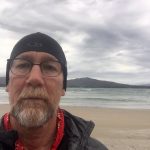
In Tasmania Day 7 Melaleuca to Cox Bight 12km
In Tasmania Day 7 Melaleuca to Cox Bight 12km Felt much better after a day’s rest and a good wander around Melaleuca. The caretakers at Melaleuca were so kind and had been on many adventures in their time. Also Kendron, the psychologist, was good for a number of long conversations over coffee. The hike to […]
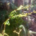
In Tasmania Day 6 Melaleuca
In Tasmania Day 6 Melaleuca Always listen to your knees—they have much to tell you, and mine said “take some time, learn about this spot of the world and rest today. Joint wisdom. The hikers huts are like old Quonset huts, curved correlated metal with some semi-transparent fiberglass panels for windows. I woke to some […]
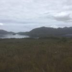
In Tasmania Day 5 Spring River Crossing to Melaleuca 21km
In Tasmania Day 5 Spring River Crossing to Melaleuca 21km Spring River must have had a flood on the last few months— many down trees making the pass all but unpassable. In my “campsite”, a space just large enough to put up my single tent, I could see low growing ferns, dead about one foot […]
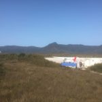
In Tasmania Day 4 Watershed Camp to Spring River Crossing 14 km
In Tasmania Day 4 Watershed Camp to Spring River Crossing 14 km I’m starting to think the Mercator Projection (which preserves latitude and longitude by drastically increasing the size of far northern and southern land masses—think Greenland) actually applies to distance measurement here. Almost as far south as you can get without traveling to Antarctica, […]