Walking Home

reveries of an amateur long-distance hiker

In Patagonia Day 20

March 11th, 2018

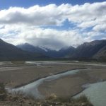
In Patagonia Day 20
El Chaltén—Lago del Desierto—El Chaltén

Today was about borders—national, hydrological, botanical, and geological. My last day in Argentina’s Glacier National Park was a shuttle ride up a rough gravel road with many one-lane wooden bridges to Lago del Desierto, a long narrow lake 37 kilometers from El Chaltén. The plan was simple: visit the lake, climb up to Huemul glacier, then mountain bike back to town, so maybe the first border I should mention is the one between me and the bicycle seat—wish I had packed the spandex riding shorts. The primary border that framed today, what has defined this area in the last 50+ years, is the watershed, the continental divide which, after much contention, settles national borders. A drop of rain falling on the mountains just past Lago del Desierto either flows to the Pacific and therefore is Chilean water, or it ends up Argentinian Atlantic water. It has not always been so simple (and probably still isn’t) but here in the 1960s, the two Patagonian countries argued about who governed a nearly empty (of humans) and generally unstudied region. In 1965, following a dispute about which country a farmer owed allegiance, there was an incident between Chilean and Argentinian forces near the lake. A Chilean, Lieutenant Hernán Merino Correa, was killed and now is considered a hero, buried in a special cemetery in Santiago. Both governments were in some internal political turmoil in that era, and the argument was not really settled until 1994, but now the area is officially part of Argentina, though from the base of the lake you can see Chilean mountains. It had occupied a place long ignored by both Argentina and Chile, so it was a marginal zone crowded in by mountains, glaciers, and impenetrable ice fields.

The story of El Chaltén itself helps explain the complexities of stabilizing borders. The Rio de Los Vueltas valley had been partly settled by Scandinavian farmers setting up estancias. Perhaps most famous was Andreas Madsen, a Dane who wrote Hunting Pumas in Patagonia and Tales of the Old Patagonia (books I have not been able to find). Still, the upper reaches had been largely ignored, and Argentina’s response after the 1965 skirmish was to push a road up to the lake and a rough path further on to the border. Today that point is occupied by the military and is a checkpoint for intrepid souls hiking through to O’Higgins township on the Chilean side. The real political move though was establishing El Chaltén itself. The youngest town in all of Argentina, it was founded in 1985 in order to open the land around Fitz Roy and Torres to tourism, and essentially to occupy a place that had previously been scarcely experienced by large groups of humans. The native Tehuelche who did not settle that particular site and who were pretty much exterminated in 19th century by General Roca, called Fitz Roy “Chaltén” which means “the mountain that smokes.” It doesn’t have the feel of a planned community. The bus station is at the entrance to the town and a wide boulevard leads to the first major intersection, continuing on after a dogleg to the left until it meets a terrace with grid steel walkways to go up to the next level. If you take a right back at the first major intersection followed by an immediate left, you are on the main road heading out toward Lago del Desierto and the Chilean border. It is initially lined with restaurants (with their competing happy hours), hostels, and outdoor adventure storefronts. Unlike El Calatafe, El Chaltén is much more relaxed. They aren’t hustling tourists to the Perito Moreno glacier but instead simply let everyone wander off on spectacular day hikes or multi-day treks. Although I have no idea what life is like there in the off-season, it does seem a vital community. Across from my hostel was a school full of boisterous children. Roberta, the hostel owner, has a daughter who attends. And isolated as Chaltén might be, that small population was out marching on International Women’s Day. It is hard to comprehend that 35 years ago, this was a windswept plain. Had Bruce Chatwin’s peregrinations taken him here, he would had to seek shelter from one of a few widely spaced estancia houses. I was enchanted by this outpost at the end of the road and near the end of the world.

Those estancias stretching up the Rio de Los Vueltas valley and in the plains to the east bring a different border awareness— the thin soil horizon, often absent, that gives ground to tufts of some tough grasses and provides grazing land for sheep, horses, and cattle. It is difficult not to be struck by the miles of fencing even in the most isolate desolate areas. At the end of summer with plenty of rain the plants are still brown and crisp. Often there are simply large open patches of granite gravel— river wash—which forms the foundation for the thin soils. It’s some hard living for plants, animals and humans. The farmhouses are easy to pick out at a distance as they are planted up with Lombardy Poplar windbreaks (similar to the high hedges on windswept farms in New Zealand). You can imagine the calm refuge they must provide and the shock of stepping out of the lee to head off into the lea for daily chores. The poplars are not indigenous but seem to thrive. The surrounding mountains are generally bare, so it is easy to see their geological architecture, but in sections sheltered from the more brutal winds, two varieties of nothofagus live. Indigenous to the area, the larger are the celebrated Lenga (Nothofagus pumilio, the best restaurant on Puerto Natales is called Lenga). A nearly identical appearing but smaller variety is the Ñire. By observing their clusters, you can understand other sorts of borders—soil horizons and microclimates. Early 20th century ranchers burned off sections of hillside to stimulate the growth of grass, but since much of the area is now National Park (the Glacier National Park is a UNESCO world heritage site) and the surrounding private land has some use restrictions, the nothafagus forests are regenerating. In the marshy and heavily disturbed areas, the Ñire do their work, and in the more stable (though still thin soiled) areas the Lenga go about transforming the barren and windswept into calm peace.

One last border—the Pacific Ocean, not as an end point but as a new barrier separating lands that had once been cheek by jowl. Recently scientists using flora and fauna similarities have agued that New Zealand was once nestled against the Patagonian coast. Apart from marked similarities in geological activity, those two places are one of the few places where nothafagus exist indigenously, though instead of Ñira and Lenga, the Kiwis have red, hard, mountain, and black. As Joan Maloof and Peter Wohlleben each observe, the beech is a tree with special qualities, as anyone who has wandered through an old growth beech forest can attest. Technically the nothofagus are not actual beeches, hence the appellation “false beech.” The Patagonian/New Zealand versions are different from their European and North American counterparts, but as someone who has had the opportunity to wander through groves of each, they are every bit as magical.

T. Hugh Crawford