Walking Home

reveries of an amateur long-distance hiker

Day 81

November 23rd, 2015

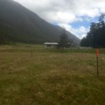
Nov 20 day 81 Boyle Village (Reefton) to Kiwi Hope Hut 10:45-5:30 25 km

image

In the middle of the night the rain started–I could hear it on the motel’s metal roof. I woke at six, but the bus to Boyle Village did not leave until 9:00. I watched the news and drank all the complementary instant coffee, then ventured out to find breakfast. None of the likely cafes were open, so I sat by the Spark free wifi for a while updating my blog and answering email. When it became clear the cafe I had hope to go to was not going to open, I went back to the motel and ate in their restaurant (the only customer they had). The bus back up the mountain was in the pouring rain, but it lightened a bit when we crossed Lewis Pass. Picked up my food at the outdoor center–pack is as heavy as it will ever be– and headed down the road to windy point, the entry area for when the river is too high to ford. A long, uneventful road walk, had lunch in the bus shelter where I met some nice hikers just finishing a week out. They are from the Victoria University tramping club, and I gave them contact info so maybe we can arrange a talk about the TA. Then I plunged into the bush for the next 16 km to Kiwi Hope hut. Very wet and rainy walk, much beside a very rain swollen river. They really get high and wild with enough rain, and the trail went vey close o the torrent often. Arrived at the hut and met Alex and Courtney who I have been trailing for some time now. Very good conversation and stayed up a little late.

Day 80

November 19th, 2015

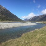
Nov 19 day 80 Anne Hut to Boyle Village (Reefton) 6:45-2:30 29 km

image

Once again I was a walker of rivers. Set off fairly early from the hut. All the other hikers were still in their sleeping bags, but the DoC ranger, who I had met the other day while he was gathering seedlings of an endangered bush, was up along with his older friend who had been out hunting deer the night before. A transcript of the first part of our conversation: “mumble mumble bloody mumble bloody bloody mumble mumble.” Apparently a translation of that is that he had killed a deer the night before and the younger man– the DoC ranger– had gone out to bring back the carcass. We ended up having a nice conversation in English before I set off on the day’s walk, a pleasan jaunt first up the main river valley but soon turning to follow the Anne River from its mouth to its headwaters at the Anne Saddle. There the waters parted, and I descended down for the rest of the day along the Boyle River into Boyle Village which was a ghost town. I walked through the Outdoor Education Center which is where I was supposed to stay, and also down the only other street. Not a soul to be found. The sand fleas were outrageous, and a quick check with the TA paperwork showed a shuttle bus to Reefton, a town not far away where I could resupply and sleep without be consumed by sand fleas, so I decided to go to Reefton, the closest town with a grocery store in case I could not get my parcel. Stayed in the Automotel, not the best place, but had a nice meal at the Alfresco Restaurant and got all my stuff together.

Day 79

November 19th, 2015

Nov 18 day 79 Waiau Forks to Anne Hut 7:45-4:30 34 km

image

After yesterday’s exertions and the cold temperatures, it was hard to crawl out of the old bag this morning. Still, it was bright and beautiful in the woods, and I could see my jet boil on top of a stump so I could almost taste the coffee. Last night I built a fire, probably more to not be alone than for the need for heat, but I was able to dry my socks and shoes. Of course, the very first thing I had to do was wade through an icy river. All I could do was laugh and enjoy the fact that I could not feel my feet for part of the the morning. After some initial rockfield boulder hopping, the valley widened out, and the trail became flat and smooth, then became part of a four-wheel drive road for the rest of the day. Was windy but very sunny, and watching the valley open up as I walked down was magnificent. The only thing that broke up the pace were numerous still icy stream crossings, some thigh deep with very swift water. I met a French couple on the way. He had injured himself on the ice at the top of Waiau Pass and was struggling walking. After some pain pills, he was able to continue and they made it to the hut a few hours after I did. Anne Hut is new and quite large, housing me, a woman from Australia, and couples from France and Colorado. A quiet afternoon, sitting out in sun on front deck, then big dinner.

Day 78

November 19th, 2015

Nov 17 day 78 Upper Travers Hut to Waiau Forks freedom camp 7:00-6:00 23 km

image

Woke up to Grant, the hike leader, stoking the fire in the wood stove, and before too long the crew started rustling about. I packed up, made oatmeal and coffee (can have all I want now that Grant gave me an extra cylinder of isobutane). I really like the hikers from Australia so I had a second cup of coffee and talked with them when I really should have been trekking. Ideally I wanted to get to Waiau Forks to camp, but that required first an early morning climb over Travers saddle which is 1700 + meters and then, late in the day, Waiau Pass which at 1800+ meters is the highest point on the South island part of the TA. So regretfully I said my farewells and started the climb. A sunny clear day as I climbed up out of the bush to open ground. All around were snow capped peaks, so the climb up was glorious. I made it to the top within an hour and started the long descent to the Sabine River valley. The winter snows, avalanches, and rock slides had pretty well taken out all the poles marking the lower part of the decent so I followed tracks and cairns and eventually found the trail through the woods to the West Sabine Hut where I crossed the river and made my way up to Blue Lake. Like the Travers, the Sabine is clear and fast running, so much fun to to spend a day walking beside it. At its headwaters is Blue Lake which, according to the sign, is the clearest, most optically pure freshwater lake in the world. Not sure about that, but it is beautiful and absolutely transparent. I got there by 1:00 so decided there was enough daylight to make the trek over Waiau Pass. The trail took me past Lake Constance which rivals Blue in color and beauty though getting around it required some hard climbing and narrow ledge hiking. The last bit was on a gravel beach at the water’s edge which was magical. The waters coming into it came across a wide flat plain that the trail followed. It gradually narrowed to a canyon surrounded by high snow-capped mountains with not anything that looked like a pass in evidence. The trail markers then made a sharp turn and went straight up the side of one of the mountains which might have had a little bit of a dip in altitude compared to the others, but hardly something to name “pass.” The initial climb was on loose gravel so each step slid back almost as much as it went forward. After an hour or so, I got the the first leveling off, though there was much more altitude to gain. In mid-winter this is a high avalanche risk area, and I’m not sure what conditions reduce that risk in the spring, but soon I was crossing snowfields on the way up, and once on the top, it was all snow for about a third of the very long descent. Fortunately some people had been through in the last day or so, and I was able to follow their footsteps down. I’m not sure how deep the snow was, but I would sink to about mid calf on each step. With cold feet I finally got below snow line, followed the western branch of the Waiau River to where it met the eastern half, and (after 11 hours of hard hiking) I pitched my tent in a beech forest beside the river, built a small fire to dry out my shoes, and gratefully crawled into my tent and sleeping bag, ready for a hard night’s sleep.

Day 77

November 19th, 2015

Nov 16 day 77 St Arnaud to Upper Travers Hut 9:00-5:30 30 km

image

Water. The most beautiful story Hemingway wrote was “Big Two-Hearted River” where Nick Adams, the protagonist, is recovering from the metal anguish of World War I, so he goes fishing in Northern Michigan. At one point he leans over a bridge rail and sees big trout holding steady in the river’s current. I woke early at the backpacker hostel of the Nelson Lakes Motel. Dave, a hiking guide was in the kitchen working up breakfast for his crew from Spain. I made coffee (several cups), talked with him then packed up and headed out– not to the trail just yet. In keeping with my TA resolution not to eat food from my pack when there is a restaurant nearby, I wandered down to the St. Arnaud Cafe for the big breakfast and more coffee. A very cold morning, I sat at the picnic tables outside waiting for the cafe to open and catching up on Internet work on the free Spark wifi. After breakfast and an ice cream bar for dessert (you can eat anything you want if you hike all day), I headed down the trail which first was an easy, flat walk around Lake Rotoiti. At the end, a river valley opened up and the trail followed Travers River, as it turns out, its entire length. In the lower parts it as fairly wide and flat, but perfectly clear and the most unimaginable blue green color. I think if there were a contest to chose the most beautiful color in the world, the water of Travers river would win. It was a long hike to Upper Travers Hut (30 km), but it took me from the mouth to the headwaters, so I got to see the river’s life unfold across the day, from the staid maturity of the mouth to the rollicking turbulence of its youth (yes, the water really does rollick over the rocks). The trail would wind through the woods and rocks, then return to the waters edge, giving a whole new perspective and understanding. Yesterday the water was mountaintop snow so tasting was ice and as intoxicating. No, the opposite as there were no toxins anywhere near it. I stopped once to look into a deep pool though it is very difficult to judge depth when you can see through it so clearly. As I stared at the bottom– perfect round blue-gray stones– a trout caught my eye. Large, brown, at least 22 inches long, the fish held steady in the current and I then understood Hemingway’s story. The Travers River is rushing fast, it is plunging down the mountain to the lake below, waterfall after waterfall. Even slack water is anything but a slacker. That fish holding motionless was swimming fast. Holding steady is hard work. Although smaller streams had been joining the river all day, toward later afternoon, they came rushing in harder and louder. The trail became steeper and wound around and through them, and the surrounding mountains started to loom, casting dark shadows. Then I saw, dropping straight off a mountain top, fully half of the water making up the Travers river at that point. It as as if someone had just taken half the river and leaned it against a very tall mountain, then let it fall. Rushing vertically for hundreds of meters– no words. The day was winding down as I finally made my way to the hut which, much to my surprise, had smoke coming from the chimney. On entering I was met by a hiking party, two Kiwi guides from Picton and four fascinating women from Australia. Rather than my usual solitary evening in a quiet hut, I was treated with food, wine, even a little whiskey, but best was lively conversation. A remarkably pleasant evening capping a day of learning about the life of a river.

Proximity

November 15th, 2015

Proximity

image

Perhaps the most frequent but often unvoiced question that walking gives rise to is “how far?” or “am I near?” Walking is primordially an engagement with near/far. But near and far are relational terms. A far person can be many miles from another, whereas a chess piece can be far from another on a board. Or the baker’s tansformation, where a point on rolled then folded dough moves from far to near in an instant. Hiking near and far can be measured in feet. Today I took quite a tumble because I was looking ten feet ahead instead of six. For humans, near and far are experiential phenomena which become known through the possibility of movement or communication. Once again, a comment from Thoreau is a point of entry to question the experience of proximity: “Our inventions are wont to be pretty toys, which distract our attention from serious things. They are but improved means to an unimproved end, an end which it was already but too easy to arrive at; as railroads lead to Boston or New York. We are in great haste to construct a magnetic telegraph from Maine to Texas; but Maine and Texas, it may be, have nothing important to communicate.” This could be seen as Thoreau at his Luddite best, criticizing the major technological innovations of his era– railroad and telegraph– as just pretty toys which distract us from true thought and meaningful action. One need only recall his playful imaginary journey to Fitchburg where his one self buys a ticket and rides the train while the other walks. By computing the labor-time involved in earning money for the ticket, walking Thoreau comes out ahead, granting the assumption that time spent walking is better than time spent working for wages. Still it is hard to imagine the railroad trains which run daily past Walden Pond as pretty toys (any more than, with Emily Dickinson, we can imagine them as horses). The train in this framework is not just about temporality, it is about proximity. The train transforms the notion of near and far. Or, to be more precise, the train calls us to question the functional category near/far.

Much of Walden is a meditation on just that question and a celebration of the near which has brought Thoreau much critique (including a recent New Yorker article). His intense focus on the local seems to be at the expense of global awareness and can seem overwhelmingly parochial. This is even more evident in the second technology of the above quotation– the telegraph. At least the train has the virtue of a heavy and obvious embodiment. It is, in the words of Whitman, “ponderous.” The telegraph does have wires, but the messages move by imponderous electrons. Thoreau’s questioning of this fancy toy is more pointed as he questions the value of rapid communication. Does Maine really have anything to say to Texas? and would anyone in Maine be the slightest bit interested in what someone from Texas had to say (questions that remain vital today). Regarding Thoreau, we must always recognize the hyperbole that accompanies any claim like this one. Widely read in intellectual traditions that extended beyond the USA and Europe, he was anything but a parochial intellectual. Clearly he is questioning what he saw in his townsfolk as an overweening interest in the news of the world and a concomitant failure to know or understand their locality.

image

Near and far, maps, communication technologies, and touching the local ground are staples of life on the trail. As much as you may want to always be in the moment of any given walk, you are always turning to the future. Walking opens out to a place you are not, a constant negotiation of the near and the far. The interesting question then is how those negotiations manifest. Every evening in anticipation of the next day’s walk, guidebooks and maps are consulted, ideal distance computed and plans made. But even prior to that, there are abstract computations. My Te Araroa hike is framed by necessary calendar time. Starting before September was discouraged as the weather would have been even worse than it actually was. Hiking in the rain and the mud was brutal; were the temperatures even lower it would have been impossible. And my finish date is fixed by my teaching schedule. My simple rule of thumb has been to average 25 km per day. Existentially, that is often easy to accomplish. Any given day, getting an early enough start and walking long enough usually suffices to get more than 25 km, though there are days up on alpine crossings where such distance is impossible because of surface and terrain or when weather interferes (or when both come together as happened to me on both the Tararua and Richmond ranges).

But near and far is never simply a function of distance walked, even while walking. The physically near or far are not necessarily experienced as walking near/far. Experientially many other factors come into play. Perhaps most important is the actual hiking surface– clearly an experience of nearness as your feet/shoes (and sometimes hands) are in actual contact, but also an experience of far as surfaces enable distance. There is a hiking adage, “take what the trail gives you,” which can be translated to “hike hard and fast when the path is easy.” There the surface is a function of far as well as near. Distance hiked–far–also can become almost obsessive, particularly when telecommunication technologies come into play (Thoreau was right in this way). Checking GPS position turns the experience of the near or the local into one of nearly complete futurity, always seeing not so much where you are as how far you are from an imagined destination. Then there is the landscape photograph which is always one of distance that only implies presence because you took the picture and so stood in that singular vantage point. Such mediation is very much part of navigating your way through the day, but transforms the nearness of the walk into a distance to be seen, then covered.

Walking is a way to see a landscape: stand on this spot to observe that mountain, here is a perfect place to take a picture. That is to experience landscape as far but still proximate, , but walking is also to be in the landscape. It is a way to break through the specular and be part of the viewed which is very different than regarding it. It is near not just in terms of physical proximity, but also as a way to signal that being is always being-in-the-world. The spectatorial far, particularly as it is technologically mediated, belies the simple truth that a landscape is never simply viewed from afar, but also is very much part of a near that your presence in makes manifest.

One form of far (the one Thoreau was criticizing) is the product of a static viewpoint. The world viewed is often an invitation to see it as separate, as over there. The world walked is a world where near/far are constantly switching, moving rapidly from that place over there to that place where I now move. Then near/far is experienced no so much as distance as pace, mood, fatigue or lightheartedness, pack weight, foot pain, hunger (a rumbling stomach is a clear measure of distance traveled), or anxiety about time/distance. They are also functionally related to repetition, the experience of the familiar and the unfamiliar. I began the South Island by hiking the Queen Charlotte Track, a walk I have taken twice before. Not only could I anticipate possible distances traveled, but my very familiarity with the track make the far quite near. There was much anticipation and surprise–oh, I am already here!– compared to my recent time on the Richmond Range where having to climb 900 meters in about 5 kilometeres made the near quite far. It was very much the experience as a child who constantly asks “are we there yet?”

In phenomenology, bodies in the world are experienced initially as front/back, left/right, and up/down. The next move, to be in the world as near/far, is the first to create a disjunction between self and world. The objects of that world are either felt as a clear part–near–or as more or less unrelated and disconnected–far. This I think is what Thoreau might be driving at in his criticism of some technologies. The initial experience of far is the first disjunction. The first time being is not in-the-world. (Freud’s fort/da is a version of this, but the da is absence–non-being–while the far is present but not phenomenally connected to being). Letting that version of far stand can create an attitude of a world that is not over-there, but instead is disconnected, separated, unlived. The telegraph’s solution is ironically increased separation because of unrelation. Technologically mediated forms of communication bring with them different protocols of presence, and specific bandwidths of communication. For Thoreau, they are creating an illusion of near while reinforcing a disjunctive far.

The near he is promoting is not a simple physical near. Rather, an insistence that near and far always pertain to bodies-in-the-world. His privileging of walking is by no means the only route into this insight, but it is one where the near and the far are in constant commerce, are continuously interchanging, refusing to settle into unbridgeable distance. The far is not separate from the near, it’s just a little farther away.


T. Hugh Crawford

Day 76

November 15th, 2015

Nov 15 day 76 Porters Creek Hut to St Arnaud 6:45-2:00 28 km

image

Today was a classic version of the horse smelling the barn. I was ready for regular food, a hot shower, and a cold beer, so all effort was bent to that end. Got a good brisk start on a fine cliff-edge trail, and the designers were able to build out a long distance level about half way up the ridge above various creeks and rivers. Made good time on well-made track. The views were amazing, but that seems a redundancy given the week I have had. Later in the day, the terrain shifted with tufts of grass and a lot of water. The mountains there were weeping. I had several river and stream crossings. On one small one I took quite a tumble–sharp rock in lower back which tightening my pack waist belt and a lot of hard walking seemed to ameliorate. The last half was a long run down a four-wheel track and a road walk into St. Arnaud where I had long great talk with Richard, a trekker who runs the Nelson Lakes motel (which has incredible backpackers facilities) and then with Triple Hands, a Kiwi hiking guide who is a triple crowner (AT, PCT, CDT). Got my food in order, did laundry, and tried to catch up on email. St Arnaud is a good little town, wished I had more time to be here.

Day 75

November 15th, 2015

Nov 14 day 75 Mid Wairoa Hut to Porters Creek Hut 7:15-5:15 24 km

image

One of my “pointless” essays is about “surfaces,” something that insistently called my attention all day. It started with a very sharp up, which then dropped me back down on the banks of the left branch of the Wairoa River. Just like the Pelorus, the Wairoa is that indescribable pellucid blue/green, a color I really have not seen before. The whole morning stretch was waterfall after waterfall. I was hiking upstream, and they got more dramatic the further up I got. The walking was tough though, very narrow rock ledges over sheer drops which required a lot of concentration. I could see signs where people had slipped (not bodies or bones, just long skid marks). There were also about eight stream crossings. The water was not deep enough to be of concern, but it was very cold early in the morning, and of course I then had to spend the rest of the day hiking with wet feet. Along with the stream hiking and narrow rock ledges, there were excursions into the dense forest along the river banks. There the roots of old trees were densely matted with dirt and plants in the interstices, but in many places the actual subsoil had washed out, so I was walking on a thin layer of roots and dirt suspended over a void. Often my trekking poles would go through, fortunately not my feet. It did make an oddly hollow sound and was a springy way to walk. There was a hut upriver about ten kilometers, and there the trail left to river to ascend Mount Ellis and some of the surrounding peaks (around 1600 meters). Through that stretch which was above tree-line, I felt as though I was in a contractors supply yard. I’d hike over rocks the size of basketballs, then baseball size, then increasingly finer gravel. In the afternoon, the geology of the area changed as I moved into the “red hills” which are composed of mineral rich igneous rocks with a lot of iron (hence the red). They weather sharply and the large rocks are very difficult to walk over–definitely shoe killers. The afternoon continued with the strange surfaces– more red rocks on ridges that made me expect to see the Mars Rover come cruising by. The trail kept going up and over ridges, then back down to rivers, making it difficult to get a sense of where it all was going, though the trail proper was incredibly well-marked by tall orange snow poles. Often there were long scree traverses, and toward the end of the day, instead of gravel sized scree, it was more like sand which on steep banks moved under my feet. At several places the traverse would be within ten years of a cliff drop-off. One slip, and there would be no way to stop, which made those points even more nerve wracking than the morning’s narrow cliffs. Needless to say, I was happy when I saw in the distance of the bright orange painted Porters Creek Hut. Another very long strenuous day, early to bed in hopes that I make it to town tomorrow. I hear that the Nelson Lakes Motel has a big barbecue on Sundays, all the more reason to be sure I get across those rivers and into St. Arnaud.

Day 74

November 15th, 2015

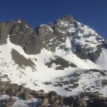
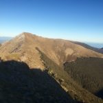
Nov 13 day 74 Slaty Hut to Mid Wairoa Hut 28 km 6:45-5:30

image

Not to be hyperbolic, but without doubt this morning’s hike was the most beautiful of the entire trip. The sun was bright, air frozen crystal with little wind. Darek and I left early, the gravel crunching beneath our feet and sprouting long thin ice crystals. It is easy to see how the soil, rocks and mountainsides heave if you just look down at pebbles suspended inches above the ground by tiny ice-crystal trees. We were both a little apprehensive. The two peaks of Mount Rintoul are famous for their difficulty. Lots of loose scree, some very narrow ledge passages near sheer drops. It is both technically and physically rigorous. It was very cold but I kept taking off my gloves to take pictures, though they are weak versions of what we are in, damn, it was just amazing. The early morning included a scramble up Old Man (which by the way is how I feel at the end of today), then a few km through scrub forest and a sharp climb, at first still in tree cover, then above tree line. By mid-morning we had summited Little Rintoul, but then the real work started, rounding the summit and dropping down a river of scree to work our way around a fractured ridge and then up to Rintoul proper (over 1700 meters). The rocks slid beneath our feet through the whole process, with Darek taking quite a tumble at one point. By late morning we were at the top and could see snow covered peaks in the distance at most points of the compass. It’s not fair to the rest of the day’s track to be compared to this morning. It was a lot more up and down, the down on very loose and skittery rocks. We got down to Rintoul hut, Darek wanted to rest there for a few hours, then go on to the next hut. I was hoping to get a little further, so I pushed on hard, making it to Mid Wairoa Hut after nearly 11 hours of very hard hiking. Took care of cooking and unpacking immediately. I’m writing this over a cup of tea, and my eyes will be closed on this day long before this day closes.

Day 73

November 15th, 2015

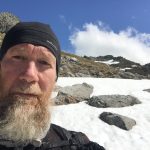
Nov 12 day 73 Slaty Hut 0 km (a snow day)

image image

So last night it started raining a bit, something the weather report had warned about. I was not too concerned because it was supposed to finish before morning, and the trails here are very dry, so a little rain would not have any impact. In the middle of the night, I went outside to piss and at first could not understand the strange light all around me: snow. It was still flurrying in the morning wth high winds. All the books say do not get near Mount Rintoul in bad weather as the passage includes a lot of rock scrambling and some very narrow ledges over steep drops. The Richmond Range might be the Tararuas all over again. I still have some serious alpine hiking ahead, much of it slow slog over scree; it will take a lot of time to get across to St. Arnaud. Spent early morning making a fire in the wood stove, reading Heidegger, and drinking coffee. In the back of my mind remains the possibility of running out of food or electricity. I have a back-up battery to keep navigation instruments going, but will have to suspend reading and writing if it starts to run down. Everything I do now requires careful deliberation. Mid-morning Darek arrived from the Starveall hut. It was still snowing a little and the wind was high, but the walk from Starveall is not technically or physically rigorous. The next hut –Old Man hut–is pretty far off the trail, and immediately after that is Little Mt Rintoul, so going on today did not make sense for him. The weather is supposed to be good the next two days, so we both decided to stay (plenty of firewood, comfortable hut) and take on the alpine scree tomorrow. Fortunately the wind dropped and the sun came out in the afternoon, melting much of the snow, so I hope tomorrow’s hike will be smooth. Got some pretty serious cabin fever by late afternoon though. Wrote a while about Thoreau, guess I need to get into his cabin frame of mind. By the end of the day, I was thinking hard about isolation, something quite different from solitude as the former brings with it a barrier and inability to communicate or engage. We may seek solitude for contemplation, relaxation, thoughtfulness, but isolation forces such modes upon us. There is a perverse pleasure in isolation, a helplessness that excuses a lack of sociality or even simple communication. It is pleasure and anxiety put together, a form of being that is both difficult and liberating.