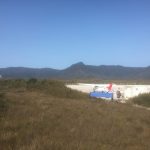
In Tasmania Day 6 Melaleuca
In Tasmania Day 6 Melaleuca Always listen to your knees—they have much to tell you, and mine said “take some time, learn about this spot of the world and rest today. Joint wisdom. The hikers huts are like old Quonset huts, curved correlated metal with some semi-transparent fiberglass panels for windows. I woke to some […]
In Tasmania Day 5 Spring River Crossing to Melaleuca 21km
In Tasmania Day 5 Spring River Crossing to Melaleuca 21km Spring River must have had a flood on the last few months— many down trees making the pass all but unpassable. In my “campsite”, a space just large enough to put up my single tent, I could see low growing ferns, dead about one foot […]
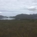
In Tasmania Day 4 Watershed Camp to Spring River Crossing 14 km
In Tasmania Day 4 Watershed Camp to Spring River Crossing 14 km I’m starting to think the Mercator Projection (which preserves latitude and longitude by drastically increasing the size of far northern and southern land masses—think Greenland) actually applies to distance measurement here. Almost as far south as you can get without traveling to Antarctica, […]
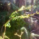
In Tasmania Day 3 Junction Creek to Watershed Camp 20 km
In Tasmania Day 3 Junction Creek to Watershed Camp 20 km Solitude! A full 24 hours and a long walk without seeing a single human (or mammal for that matter). My misanthropy rejoiced; my knees and feet did not. Today was a quintessential bog hike, slogging through shoe sucking ankle deep muck mile after mile. […]
In Tasmania Day 2 Huon Campground to Junction Creek
Day 2 Jan 15 Huon Campground to Junction Creek Becoming reacquainted with real sweat. Today’s trek was short but hot and in the mud. The swamps teem with insects. I sit here writing this in a cloud of huge buzzing flies. They don’t bite, don’t even land much, just buzz around my head. I could […]

In Tasmania Day 1
Day 1 Jan 14 Woke to cool overcast skies, stark difference from yesterday’s bright shocking Tasmanian heat—the transition from Seattle weather was abrupt as well. After many visits to Wellington NZ, Hobart has a familiar feel. A harbor stocked with boats—wooden sail and fiberglass glitz—ringed by old trade buildings: stone warehouses near the water now […]