Walking Home

reveries of an amateur long-distance hiker

Day 63

November 3rd, 2015

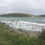
Nov 2 day 63 Paekakariki to Porirua 26 km 8:00-2:00

image

Woke in the middle of the night to a soft sprinkle on my tent. New Zealand more often than not has a heavy mist going on, particularly at night. Not quite rain, but heavier than fog. It makes a noise on the tent (the cuben fiber fabric makes a crisp sound) that sounds as if there is more rain than is actually coming down. I just needed to hike 26 km on a flat path today, so I was in no real hurry to get started. The trail passed through the village end so I stopped at the Perching Parrot coffee shop for breakfast — free range eggs– and a flat white. The barista was a woman whom I had seen at the campground last night– we joked about the rain and my sleeping in a tent. Spent most of the day hiking in cloudy, misty, windy weather, fortunately the wind was at my back. Worked my way down the Kapiti coast, basically following the railroad tracks– the passenger train that runs out of Wellington which made me realize how close I now was. The sandy beaches started giving way to rocky coast– clearly volcanic in origin– surf was rough and forbidding, such a contrast from yesterday’s sunny swimming competition. But it never really started raining hard, and it felt good to stride out in cool weather. Got to Plimmer around 11:00 and had coffee and a snack at the Kafe Orange, also a nice place. Small village cafes are spoiling me; they are one thing NZ does very well. Made me think back on my month this summer in Oxford North Carolina where the only free internet with coffee was the McDonalds (something I just could not bring myself to do though I’ll admit I have used the NZ McDonalds wifi on occasion). Early afternoon found me in Porirua. I usually imagine what it would be like to live for a while in the towns I visit. Porirua holds no attraction. Mostly warehouse buildings housing heavy trades and a small downtown with the usual takeaway shops, gaming parlors, but no character. And not a single place you would want to sit and sip a pint in. The weather still looked forbidding, but the Camp Elsdon site had a cheap single cabin. Walked downtown and had a pint at the only pub which is either “The Dog Box” or “Murphy’s Irish Pub”–another place full of gambling machines and semi-desperate patrons. I was not so much worried about the rain as I was the high winds. Tomorrow will be a lot of km, but at the end of the day I’ll be in Wellington.

Day 62

November 1st, 2015

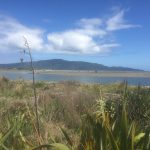
Nov 1 day 62 Waikanae to Paekakariki 21 km 10:00-3:00

image

The Otaki Hotel is not the quietest place on earth. There were people and dogs bumping and thumping all night, and I definitely did not need to set an alarm. The place was rocking at 4:30 am, half the town came in for the game and then breakfast. I naively was looking forward to morning coffee, but ended up with morning pints. The game was a classic, and the Otaki crowd was fun. Leo and Remi, my French hiking friends, were there too, so we had the foreigners table, but the guys running it took good care of us. After the game, we caught the bus to Waikanae to rejoin the trail. We had to cut off a section as it was just about impossible to get a ride back to Otaki Forks. Most of that section was on the road anyway. Leo, Remi, and I followed the TA along the river, then crossed for a swamp hike, but this one was all on elevated footpaths. Beautiful scenery took us right to the ocean (Tasman sea). Stopped for lunch in the beach town of Paraparaumu where they had shipped some equipment. As we looked for a cafe, a car stopped and let out Cory, who had stayed behind but then hitched all the way to Paraparaumu. They stayed on there, and I hiked down the beach another 10 km to the campground at Paekakariki. It is the Kapiti coast, so beach all the way down and you could see Kapiti island. At the town there was a large swimming, paddle board competition going on, which was fun to watch. Walked to the other end of town to the small village street and had an excellent meal at Finn’s Restaurant. I really need to top up as I expended many more calories crossing the Tararuas than I consumed (had almost no food in my bag when I got to Otago– will need to plan more carefully on South Island). They also specialize in craft beers which were also excellent. Was great to have a leisurely day after the physical and technical rigors of the Tararua Range. Only a few days out of Wellington and the transition to the South Island.

Day 61

November 1st, 2015

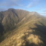
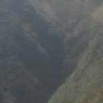
Oct 31 Day 61 Nichols Hut to Otaki Forks 18 km 7:00-4:00

image

Woke up ready, packed up in record time, stepping out into a bright but cold morning. It was sublime. Hands and feet almost numb, the ground was frozen so the trail was stable, not slippery mud. The morning trek was on razor peak trails– no more than a shoe wide, with a number of rock climbing intervals– all the way up to the top of Mount Crawford. The light, after days of mist, was crystal, and the climb perfect. Then the range turned and descended to a winding woods and lots of root hiking. Steep drops with roots and mud are my slowest surface. I worry about tripping, so the rest of the morning was tedious. I arrived at the last hut on the range to find Remi, Leo, and Cory, who had been in front of me all this stretch (I’d see their names in the hut logs). We all set off together but they were fresh and young and soon left me slogging along. More mud and roots, long afternoon, but when I got to Otaki Forks, a couple was touring around with a visitor from Spain and offered to take me to Otaki. I took a room at the Otaki Hotel (not exactly four star) and they will show the game in morning. Relaxing before dinner, glad for amazing and diverse day.

Day 60

November 1st, 2015

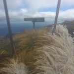
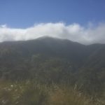
Oct 30 day 60 Waiopehu Hut to Nichols Hut 17 km 7:30-4:00

image

A hard but beautiful hiking day, humbling too. Woke to clear skies but high winds and low temperatures. The decks outside the hut were iced up. Still, it was too beautiful not to hike, so soon I was climbing the first of dozens of peaks. Encountered most high terrain trails– plenty of mud and root hiking , scrambling over and up rocks, stumbling and sliding down gravel scree or just slick mud. It was a classic ridge hike, hard up to a 1400 meter peak with a dusting of snow over it, then down one of those endless ridges, taking me up on tundra with tiny flowers under foot and cold winds blowing, then into indescribably old, twisted forests where the trees, stumps, rocks, were  all blanketed in thick green moss. It was as if you could hear it breathing. I had hoped to make it to the last hut which would have been about 25 km, but it was impossible to make good time on a trail that seemed to change every 100 meters. There was a lot of very steep slippery descending, the part of hiking where I am slowest. Still, Nichols hut was snug and had a great view. Although there was really no proper wood, I did build a fire in the wood stove to take off the chill and get my socks dried off. One disappointment is that I won’t be off the mountains in time to watch the World Cup rugby match Sunday morning. I’ll have to find a replay of it later that day when I get back to civilization.

Day 59

November 1st, 2015

Oct 29 day 59 Waiopehu Hut 0 km

image

The wind and rain continued hard through the night and into the morning. Woke to zero visibility and the trail looked like a stream. I’m not sure whether the weather here might often be more extreme, given the altitude and exposure, but people do occasionally note in the log that it was sunny, so this might not be typical. Decided to sit tight for now to see how it all unfolds. Wish I had gotten more coffee. As the day progressed I alternated between warming up in my sleeping bag and sitting at the table watching the downpour. I remembered I had some bullion cubes in my food flavor bag, so while reading of English exploration of the Arctic, I drank steaming cups of beef tea. The weather remained constant all day, though the wind dropped around 4:00 even as the rain picked up. Hoping that is a signal of some change in what has been a changeless day. Soon the rain stopped and I could see from the windows what first seemed a mirage– faint houses, fields, roads– then the clouds lifted somewhat and I could see Levin down in the flatland. Could almost pick out the campground. But the weather was not finished. Soon more rain came in, just before the clouds lifted completely and the wind began to blow from another direction. Incredibly hard and cold. Got into my sleeping bag glad it was rated to 30 degrees F.

Day 58

November 1st, 2015

Oct 28 day 58 Levin Campground to Waiopehu Hut in the Tararua range 18 km 8:30-2:30 (plus about 9 km from Levin back to the trail)

image

I didn’t enjoy yesterday’s hike (and have not felt real pleasure walking the last few days). In part it was long hiking with new shoes and wet feet which completely hamburgered my feet, but also I had just been counting kilometers and setting goals for distance and pace– bad idea because you are never just present in the walk. So this morning I lingered in my tent, enjoying a cool, misty but still somehow bright morning. I packed up, stopped at the campground kitchen (where my soap opera friends were having a big breakfast fry-up including pork chops) and made coffee while charging my phone. It was a long walk back to trailhead– took most of the morning (though I did stop for a meat pie on the way out of town). When I finally got to the trail, I had my head properly back in the hike, deciding at the first hut to call it a day even though it was early– wind was blowing and the rain was worsening. I have plenty of time to get through this range, and will enjoy the hike. Trail is well-done, though the rain is rapidly turning it to soup. This DoC hut is fairly new, good sound windows, nice steel tables, spent afternoon listening to Miles David (Kind of Blue), inventorying my food, eating throughout the process. I have enough for 5 days even though on this stretch I’ll only be out for at most two before hitting some form of civilization again. Sitting here is like being on the bridge of a ship in a storm, only I don’t have to steer. I remember Henry Beston describing his cape Cod House –The Foc’sle–in similar terms. For all I know, the Atlantic is right out there, or the Antarctic, all I can see is misty white opacity.

Day 57

November 1st, 2015

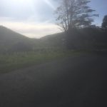
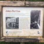
Oct 27 day 57 James Burtton Whare site to Levin Campground 30 km 6:45-4:00

image

It rained a bit in the night, but morning was fresh and misty. Slept well listening to the river and a quiet breeze. Wasn’t sure what to expect today– just knew there wouldn’t be much road walking, which seems to have been most of the last week. It was thought provoking in the first stretch. James Burtton spent more than 30 years in the first part of the 20th century not only clearing his land, building a small house and bridges, he also built the road that is now the trail. It runs out along the river, so you have to wonder how much has been washed out, but there were stretches you could see the careful construction. It was humbling. Of course, there were many stream crossings and I got wet feet early on. Hiking with wet feet is not too big of a deal except when you start out soaking and have a lot of kms, particularly a lot of up and down (which describes my day). Came out of Burtton’s track, short gravel road walk and then up on the Mangahao-Makahika track, which was all NZ tracks in microcosm. First a fairly steep up to a couple hours of ridge hiking, classic up and down in some amazing trees that were completely sheathed in ferns. As the trail wore on, and the rain increased, it soon became a classic muddy root hike. After passing the top peak which had an overlook, but given the weather there was nothing to see except a tent pitched at the top, containing I guess hikers avoiding the rain and mud for a little longer. After the peak, it descended rapidly and I was ready for some farm road hiking, but no luck. The second part of this all-terrain trail was classic swamp hiking, shoe-sucking mud, crossing streams and rivers every five minutes. Completely lost track of how many times I crossed the river, but there were no dry shoes, that’s for sure. My final destination was open as I thought if it were an easy day, I’d try for the first hut on the next track, a long day, but possible. Well, after rain, mud and rivers, it was not a possibility. Instead, on coming out of the M-M track, I took the TA overlook track to Levin, which is either on the trail or a detour, depending on what TA document you consult. Found the Levin Holiday Park, pitched tent, did laundry (and put my shoes by the dryer vent–it is amazing how satisfying it is to find a simple effective strategy). While the clothes were In the dryer, I checked email in the TV room. A mother/daughter pair came in (Maori) who were on a short vacation from their home in Taupo. They wanted to watch an Australian soap opera, which brought high drama through a kidnapped young woman held in a remote area, but she was able to get her captors phone and email her coordinates to the one man who would walk through fire to save her– and he did (well, not the fire part). We all laughed, ohh’ed and ahh’ed through it. Was great fun. I then ducked out for dinner at Fat Boyz pub, read a bit, then crawled into my trusty tent for good sleep, with only the faintest patter of rain in the night.

Day 56

November 1st, 2015

Oct 26 day 56 Palmerston North to James Burtton Whare site 34 km 7:30-4:00

image

Half way through! It was good it get in a long hard day. Winding out of Palmerston the trail goes up through Massey University. I missed the path that went up by a stream and found myself walking parallel to it on the campus. It was Labour Day so the place was deserted–almost. The security guard stopped me to see what I was doing. I convinced him I was a harmless, slightly lost backpacker and went on my way. Much of today’s walk was on gravel roads and mountain bike trails, but the countryside was beautiful, so it was easy to keep a good pace. Mid afternoon I passed the 1500 point, just as the trail ducked off a peak and would track down through some mud and bush. Finally got my new shoes dirty. A well-made trail wound down through a pretty, deciduous forest to some streams which I had to wade across, and the Tokumaro River which I crossed twice, so not only did my shoes get muddy, they also got clean (and wet). After the second crossing, I came to the site of James Burtton’s home. He lived there in the first part of the 20th century and built the trail out to the road to transport his farm products. His fields were across the river and he died while crossing a suspension bridge he had built–sad story as he fell 8 meters, broke his leg and had other injuries. He crawled to a neighbors house, but it took 12 hours and he soon died. Had a nice conversation with a kiwi section hiker named Ryan WoolIey, then pitched my tent in the grassy space and rested my weary bones.